Feeds:
Posts
Comments

Posts Tagged ‘geography’

Photo: C. Stanish/University of Sydney.
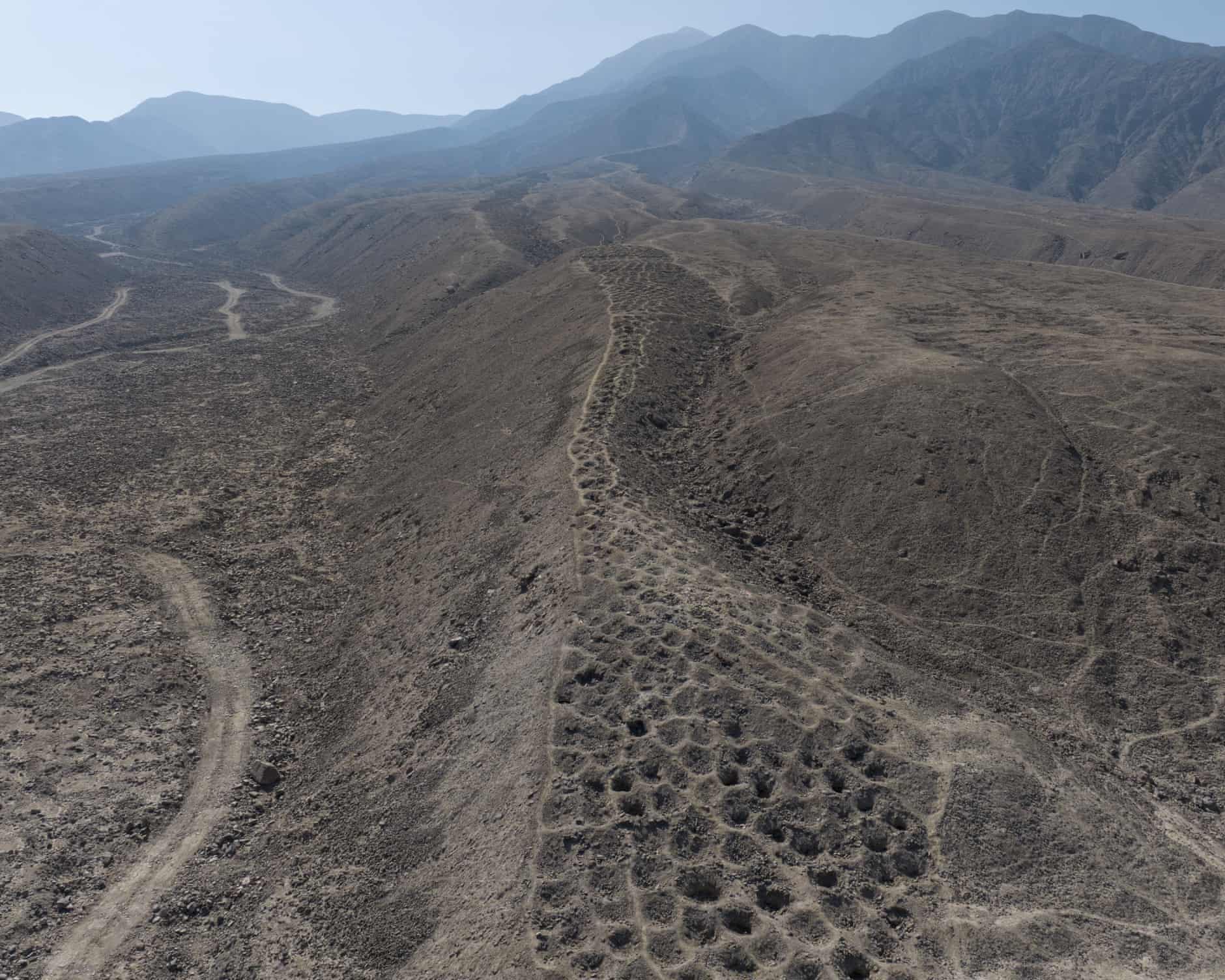
Band of Holes, known as Monte Sierpe in Peru, may have been an accounting and storage system.

Sometimes the mysteries on Planet Earth can be solved just by looking at the facts in a new way. Today’s article is on probing a geographical problem, but I can’t help wondering, What if we tried tackling other intransigent problems by just looking at the challenges differently?

Richard Luscombe reports at the Guardian, “A Florida archaeologist’s decades-long persistence has helped solve one of Peru’s most puzzling geographical conundrums: the origin and purpose of the so-called Band of Holes in the country’s mountainous Pisco Valley.

“Charles Stanish, professor of archaeology at the University of South Florida, and an expert on Andean culture, spent years studying the more than 5,200 curious hillside shallow pits known to local residents as Monte Sierpe — serpent mountain.

“He surmised during numerous field trips since the 1980s that the holes were man-made indentations created during the pre-Inca period for a rudimentary market place, then adapted by Incan civilization into a sophisticated kind of accounting and storage system, likely for agriculture.

“Rival theories abounded — from the sensible to the bizarre. [One] aired on the Ancient Aliens television program and exploited by an enterprising travel company was that they were crafted by extraterrestrial beings, perhaps to cover up the crash of their spacecraft.

“Now Stanish, in partnership with Dr Jacob Bongers of the University of Sydney, his former graduate student at the University of California, Los Angeles, believes he has found the smoking gun. On their most recent expedition they used advanced drone technology to conduct the first comprehensive aerial mapping of the site, producing high-resolution images revealing ‘striking patterns’ in how the holes were organized.

“The rows of holes, each between 3ft and 6.5ft wide, appeared segmented and mathematically structured, they said, a layout mirroring khipus, knotted-string devices the Inca used for counting and record keeping.

“ ‘Monte Sierpe is extremely difficult to map from the surface,’ Stanish said. ‘Even from the mountain above you can’t see its full pattern because of the permanent haze in the area. And because there were few artifacts, archaeologists couldn’t date or interpret it accurately.’

“Even more conclusive, Stanish said, were the results of microbotanical analysis of sediment samples taken from inside the holes. Fossilized seeds revealed traces of crops such as maize and wild plants traditionally used for weaving and packaging goods.

“ ‘We proved that the seeds didn’t fly in, they weren’t airborne, they had to be put there by humans,’ he said. ‘We didn’t get any, with one exception way down below, colonial-era seeds, and we got one carbon-dated to slightly pre-Inca. … And the coolest stuff was we found the reeds, the traditional reeds and the willows that the Inca and the Quechua peoples use to carry commodities, even up to the present day.’ …

“Stanish said future work will focus on further analysis of the recovered seed samples, while Bongers plans to lead an upcoming expedition for more excavation. …

“He said he hoped that authorities in Peru would recognize the historical significance of the holes, and move to protect them.

“ ‘I’m not worried about tourists, about foreigners coming,’ he said. ‘I’m worried about landowners getting the land and then irrigating it. People have to make a living. [But] this is a precious site, for the Indigenous peoples and for their pride, and it’s important to recognize that.’ “

More at the Guardian, here.

Read Full Post »

Photo: Arctic Images/Alamy.
Surtsey Island, off Iceland’s Vestmannaeyjar archipelago. It is rare for such longlasting islands to be created from eruptions – the last one was Anak Krakatau in 1927. 

How amazing to witness the birth of an island. People who live in Iceland have a better chance of that than most of us as Iceland is still bubbling with volcanic activity.

At the Guardian, Patrick Greenfield reports on what can be learned from an island that emerged in the 1960s. He starts with the fishermen who first noticed something unusual was going on.

“The crew of the Ísleifur II had just finished casting their nets off the coast of southern Iceland when they realized something was wrong. In the early morning gloom in November 1963, a dark mass filled the sky over the Atlantic Ocean. They rushed to the radio, thinking that another fishing vessel was burning at sea, but no boats in the area were in distress.

“Then, their trawler began to drift unexpectedly, unnerving the crew further. The cook scrambled to wake the captain, thinking they were being pulled into a whirlpool. Finally, through binoculars, they spotted columns of ash bursting from the water and realized … a volcano was erupting in the ocean below.

“By the time the sun had risen, dark ash filled the sky and a ridge was forming just below the surface of the water. By the next morning, it was 10 meters high [about 33 feet]. … An island was being born.

“Two months later, the rock was more than a kilometer long [0.6 mile]and 174 metres high [571 feet] at its peak. It was named Surtsey after the fire giant Surtr from Norse mythology. … It would be two years before it stopped erupting completely.

” ‘It is very rare to have an eruption where an island forms and is long lasting. It happens once every 3,000 to 5,000 years in this area,’ says Olga Kolbrún Vilmundardóttir, a geographer with the Natural Science Institute of Iceland. Those that do form are often quickly washed away by the ocean, she says.

“The emergence of Surtsey presented researchers with a precious scientific opportunity. They could observe how life colonizes and spreads on an island away from the human interference that has overtaken much of the Earth. …

If space is given, nature will always find ways to return, often faster and more creatively than we expect.

“The first scientists that stepped on Surtsey in 1964 could see that seeds and plant residues had been washed ashore. … Scientists had expected algae and mosses to be the first colonizers, building up a base of soil that would eventually support vascular plants. But that step was skipped completely. More plants were washed ashore in the following years, and some clung to the island’s bare volcanic rock. But after a decade, the changes seemed to stall.

“Pawel Wasowicz, director of botany at the Natural Science Institute, says: ‘People thought, what now? Around 10 species had colonized Surtsey at that point. The plant cover was really scarce. But then the birds arrived.’

“In the early 1980s, black-backed gulls started to nest on sections of the island, sheltering in one of the stormiest parts of the Atlantic Ocean. Their arrival kicked off an explosion of life. Guano carried seeds that quickly spread grasses along the island, fed in turn by the nutrients from the birds. For the first time, whole areas of bare rock became green.

“Wasowicz says … ‘Biologists thought that it was just plant species with fleshy fruits that could travel with birds. But the species on Surtsey do not have fleshy fruits. Almost all of the seeds on Surtsey were brought in the feces of the gulls.’

“One lesson from this living laboratory is that recovery after disturbance does not follow a single, predictable path, he says. Instead, it is shaped by multiple, sometimes surprising forces.

“Today, grey seals are the latest arrivals to drive changes in the island’s biodiversity. The volcanic rock has become a crucial ‘haul-out’ site where seals come ashore to rest and molt, as well as a breeding ground where they can raise their young safe from the orcas lurking nearby. …

“But the researchers warn that the colonization of Surtsey will one day go into reverse. The grey seal haul-out site is one of the areas slowly being eroded by the ocean. By the end of the century, scientists project that little will be left from that section of the island.

“Its biodiversity will probably peak, then fall over time … but the researchers say that lessons will remain.

“Surtsey demonstrates that, even in the harshest environments, resilience and renewal are possible, says Wasowicz. It offers hope and practical lessons for rehabilitating ecosystems damaged by war, pollution or exploitation. …

“Vilmundardóttir says: ‘I feel that Iceland is really contributing something important to humankind by preserving this area. On the mainland, the impact of humans is everywhere. When I am on Surtsey, I am really in nature. All you can hear are the birds.’ You see orcas along the coastline and the seals popping out and watching.’ “

More at the Guardian, here.

Read Full Post »

I was talking to my neighbor on the train this week, and she told me that one of her daughters — the one who goes to Brandeis and was in a production of Eddie Coyle that I saw at Oberon — is spending a chunk of this school year in Morocco.

I was curious about how her daughter got interested in joining a program there.

Apparently she likes languages. First she learned Yiddish. Last year she decided to learn Arabic. Her mother says Arabic is much harder.

The daughter will live with a host family, take five classes, and … well, she has her own blog. There she writes that she will be in Morocco for four months as part of a program “called AMIDEAST, which, like most study abroad programs in Morocco, is stationed in Rabat. … I’ll get to intern/volunteer six hours a week for a local business/organization!”

I like her enthusiasm.

A word to the wise for readers from other countries. There’s a lot of joking in her blog, not to be taken seriously the way a Chinese news outlet once took seriously a story at The Onion that was of course a complete fiction.

Map from http://jojomorocco.blogspot.com

Read Full Post »