Feeds:
Posts
Comments

Posts Tagged ‘lidar’

Photo: BBC.
A PhD student found a lost city by accident in eastern Mexico, in Campeche.

Talk about happy accidents! I’m sure we have all experienced a few, whether in cooking or driving around. And we often hear of happy accidents in science. Today, we learn about an alert PHD student who found an ancient civilization without precisely looking for one.

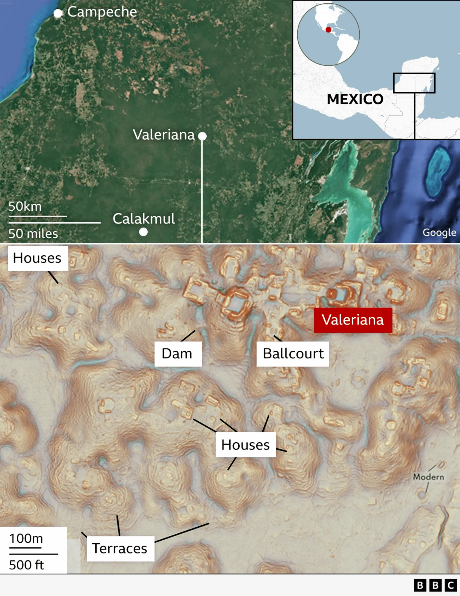
Georgina Rannard writes at the BBC, ” ‘I was on something like page 16 of Google search and found a laser survey done by a Mexican organization for environmental monitoring,’ explains Luke Auld-Thomas, a PhD student at Tulane university in the US.

“It was a Lidar survey, a remote sensing technique which fires thousands of laser pulses from a plane and maps objects below using the time the signal takes to return.

“But when Mr Auld-Thomas processed the data with methods used by archaeologists, he saw what others had missed — a huge ancient city which may have been home to 30,000-50,000 people at its peak from 750 to 850 AD. … Mr Auld-Thomas and his colleagues named the city Valeriana after a nearby lagoon.

“The find helps change an idea in Western thinking that the Tropics was where ‘civilizations went to die,’ says Professor Marcello Canuto, a co-author in the research. Instead, this part of the world was home to rich and complex cultures, he explains. …

It is ‘hidden in plain sight,’ the archaeologists say, as it is just 15 minutes hike from a major road near Xpujil, where mostly Maya people now live.

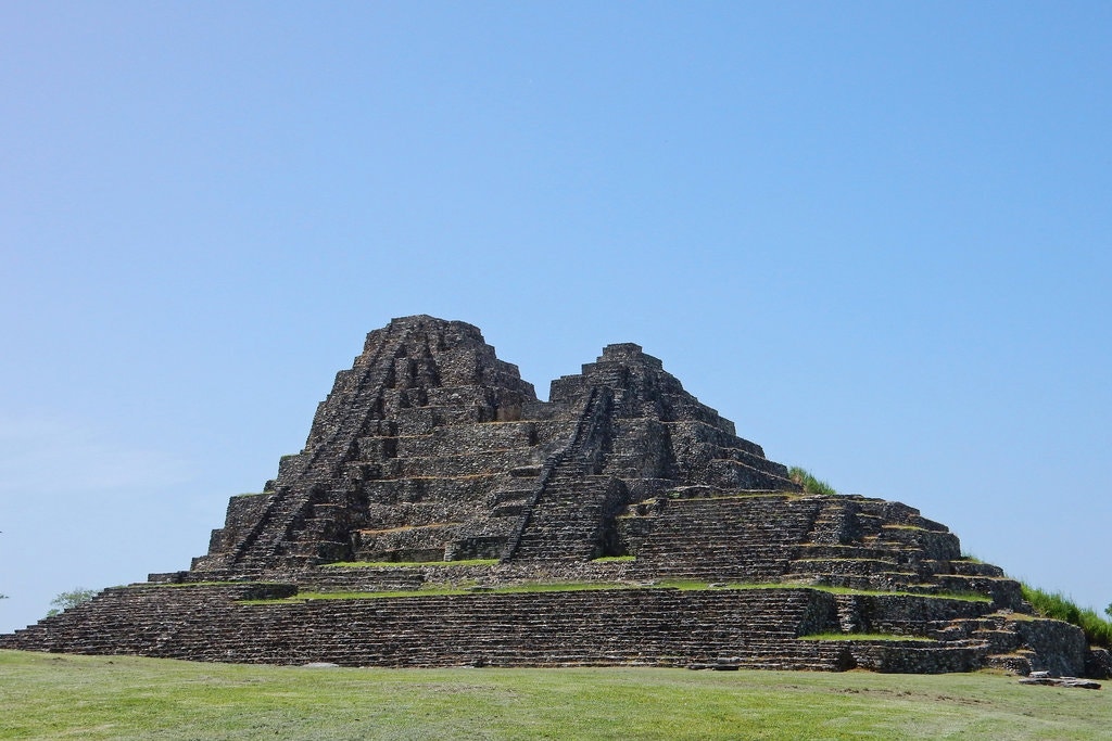
“There are no known pictures of the lost city because ‘no one has ever been there,’ the researchers say, although local people may have suspected there were ruins under the mounds of earth.

“The city [had] two major centers with large buildings around 2km (1.2 miles) apart, linked by dense houses and causeways. It has two plazas with temple pyramids, where Maya people would have worshipped, hidden treasures like jade masks and buried their dead. It also had a court where people would have played an ancient ball game. There was also evidence of a reservoir, indicating that people used the landscape to support a large population. …

“Professor Elizabeth Graham from University College London, who was not involved in the research, says it supports claims that Maya lived in complex cities or towns, not in isolated villages. …

“The research suggests that when Maya civilizations collapsed from 800 AD onwards, it was partly because they were so densely populated and could not survive climate problems.

” ‘It’s suggesting that the landscape was just completely full of people at the onset of drought conditions and it didn’t have a lot of flexibility left. And so maybe the entire system basically unravelled as people moved farther away,’ says Mr Auld-Thomas.

“Warfare and the conquest of the region by Spanish invaders in the 16th century also contributed to eradication of Maya city states.

“Lidar technology has revolutionized how archaeologists survey areas covered in vegetation, like the Tropics, opening up a world of lost civilizations, explains Prof Canuto. …

” ‘I’ve got to go to Valeriana at some point. It’s so close to the road, how could you not? But I can’t say we will do a project there,’ says Mr Auld-Thomas. ‘One of the downsides of discovering lots of new Maya cities in the era of Lidar is that there are more of them than we can ever hope to study,’ he adds.

“The research is published in the academic journal Antiquity.

More at the BBC, here. Seems to me the discovery was hardly an accident. Anyone with the patience to look at page 16 of a Google search deserves a bit more credit.

Read Full Post »

Photo: Michael Frachetti.
Using a drone equipped with LiDAR (light detection and ranging equipment), archaeologists have mapped two abandoned cities in the mountains of Uzbekistan. The location of the larger city, known as Tugunbulak, is pictured above

Over the years, I’ve read quite a few novels from other lands and cultures, including one unsettling story about nomads in Africa and another called The Railway, by Uzbek writer Hamid Ismailov. Possibly something died in translation, because I remember little of either book. Wikipedia reminds me that The Railway is about a small town on the Silk Road as seen through the eyes of its inhabitants.

Although the books did not come across as great literature, the cultures continue to draw one who hears so little about them from the American media unless it’s radio show The World. The Monitor and Reuters also seek out such stories.

Will Dunham of Reuters reports, “In the mountains of Uzbekistan, archaeologists aided by laser-based remote-sensing technology have identified two lost cities that thrived along the fabled Silk Road trade route from the 6th to 11th centuries AD — the bigger one a center for the metal industry and the other reflecting early Islamic influence.

“The fortified highland cities, located three miles apart at around 6,560-7,220 feet above sea level, are among the largest known from the mountainous sections of the Silk Road, the sprawling web of overland trade routes linking Europe and the Middle East to East Asia.

” ‘These cities were completely unknown. We are now working through historical sources to find possible undiscovered places that match our findings,’ said archaeologist Michael Frachetti of Washington University in Saint Louis, lead author of the study published in the journal Nature.

“The bigger of the two, called Tugunbulak, covered about 300 acres, with a population perhaps in the tens of thousands, the researchers said. It was one of the largest cities of its time in its region of Central Asia, rivaling even the famed trade hub Samarkand situated about 70 miles away. It existed from around 550 to 1000 AD. …

“The other city, Tashbulak, was only a tenth the size of its neighbor, with a population perhaps in the thousands, the researchers said, lasting from around 730-750 to 1030-1050 AD.

“Founded in early medieval times in what is now southeastern Uzbekistan, the cities were eventually abandoned and forgotten until archaeologists came across the first evidence of them while scouring a rugged mountain area, with deep ravines, steep ridge lines and forests. They deployed drone-based lidar remote scanning to map the scale and layout of the sites. …

“It revealed evidence of numerous structures, plazas, fortifications, roads, habitations and other urban features.

“Preliminary excavation at one of Tugunbulak’s fortified buildings — girded by thick earthen walls — yielded the remains of kilns and furnaces, indicating it was a factory where metalsmiths may have turned rich local deposits of iron ore into steel.

“The researchers are working to confirm steel was made there by chemically analyzing slag — a byproduct of iron and steel production — found at the site. The region in the 9th and 10th centuries was known for steel production. …

” ‘Tugunbulak in particular complicates much of the historical understanding of the early medieval political economy of the Silk Routes, placing both political power and industrial production far outside the regional “breadbaskets” such as Samarkand,’ Frachetti said.

“Tashbulak lacked the industrial scale of Tugunbulak but boasted an interesting cultural feature — a large cemetery that reflects the early spread of Islam in the region. Its 400 graves — for men, women and children — include some of the oldest Muslim burials documented in the region.

” ‘The cemetery is mismatched to the small size of the town. There’s definitely something ideologically oriented around Tashbulak that has people being buried there,’ Frachetti said.

“Islam arose on the Arabian Peninsula in the 7th century and rapidly spread in the successive centuries. The Silk Road enabled economic, cultural, religious and political exchanges between East and West, as the caravans that traversed its pathways toted not only a panoply of products but also people and ideas. It linked cosmopolitan Chinese cities such as Xi’an to destinations including the Byzantine capital Constantinople and the sophisticated Islamic metropolis Baghdad. More at Reuters, here.

I must say, this research sounds like fun to me. You discover a city no one knows anything about except its location on the Silk Road, and then you go back and read all the ancient documents you can on the Silk Road — the history, the legends — and look for a likely match.

Read Full Post »

00sci-mayanlidar7-jumbo

Photo: Takeshi Inomata
Human activity at the Mayan city Moral Reforma in Mexico ended about 1,400 years ago. Recently, researchers figured out that
lidar maps revealing underground Mayan archaeological sites, though ordinarily costly, are free if you know where to look.

It often takes time, a creative thinker, and a hot tip to uncover the best way to access technology. In this example, an archaeologist learned that the expensive underground maps he needed for his research could be found free online.

Zach Zorich writes at the New York Times, “Until recently, archaeology was limited by what a researcher could see while standing on the ground. But light detection and ranging, or lidar, technology has transformed the field, providing a way to scan entire regions for archaeological sites.

“With an array of airborne lasers, researchers can peer down through dense forest canopies or pick out the shapes of ancient buildings to discover and map ancient sites across thousands of square miles. A process that once required decades-long mapping expeditions, and slogging through jungles with surveying equipment, can now be done in a matter of days from the relative comfort of an airplane.

“But lidar maps are expensive. Takeshi Inomata, an archaeologist at the University of Arizona, recently spent $62,000 on a map that covered 35 square miles, and even was deeply discounted. So he was thrilled last year when he made a major discovery using a lidar map he had found online, in the public domain, entirely for free.

“The map, published in 2011 by Mexico’s National Institute of Statistics and Geography, covered 4,440 square miles in the Mexican states of Tabasco and Chiapas. …

“Dr. Inomata learned about the map from Rodrigo Liendo, an archaeologist at the National Autonomous University of Mexico. The resolution of the map was low. But the outlines of countless archaeological sites stood out to Dr. Inomata. So far, he has used it to identify the ruins of 27 previously unknown Maya ceremonial centers that contain a type of construction that archaeologists had never seen before. …

“His findings have not yet been peer-reviewed, but Dr. Inomata has presented his work at four conferences during the past year. ‘The stuff he is finding is crucial for our understanding of how Maya civilization developed,’ said Arlen Chase, an archaeologist at Pomona College, who did not contribute to Dr. Inomata’s work. …

“The 27 sites he identified on the map have a type of ceremonial construction that Dr. Inomata and his colleagues had never seen before — rectangular platforms that are low to the ground but extremely large, some as long as two-thirds of a mile.

“ ‘If you walk on it, you don’t realize it,’ Dr. Inomata said of the platforms. ‘It’s so big it just looks like a part of the natural landscape.’ The similarities between these sites and the early buildings they found at Ceibal led them to believe they both date to sometime between 1000 B.C. and 700 B.C. …

“While lidar technology is giving archaeologists new ways to analyze the ancient world, the change in perspective has been shocking and a little disorienting for some researchers. Marcello Canuto, director of the Middle American Research Institute at Tulane University, was the lead author of a lidar survey that covered 800 square miles of the Petén rainforest in Guatemala. He is also the director of an excavation at the Maya city of La Corona. Seeing the edges of the city as well as buildings between cities and the roads that connected them was shocking to him.

‘The word that all of us used when we started looking at the lidar was “humbling,” ‘ he said. ‘It humbled all of us in showing us what we had missed.’

“Dr. Inomata agreed. Even in areas where they were busy excavating, he said, ‘lidar was showing us things we didn’t notice.’ This included broad causeways and agricultural terraces, which are difficult to see in an excavation. …

“Viewing the archaeology of an entire region, in detail, will allow archaeologists to answer bigger-picture questions, such as the ones that Dr. Inomata has about the interactions the Maya had with the Olmec at the beginning of their civilization. …

“ ‘The future pattern,’ Dr. Inomata said, ‘will be that everything will be covered by lidar, like topographic maps today.’ ”

Lots more detail at the New York Times, here.

Read Full Post »