Feeds:
Posts
Comments

Posts Tagged ‘lost cities’

Photo: Michael Frachetti.
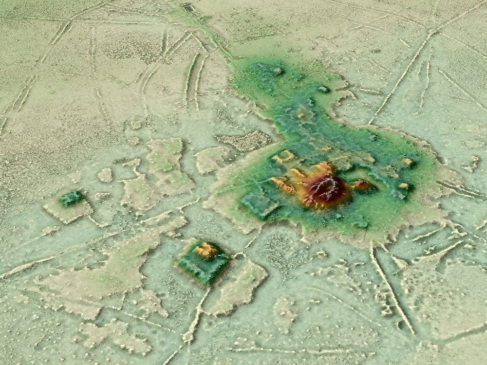
Using a drone equipped with LiDAR (light detection and ranging equipment), archaeologists have mapped two abandoned cities in the mountains of Uzbekistan. The location of the larger city, known as Tugunbulak, is pictured above

Over the years, I’ve read quite a few novels from other lands and cultures, including one unsettling story about nomads in Africa and another called The Railway, by Uzbek writer Hamid Ismailov. Possibly something died in translation, because I remember little of either book. Wikipedia reminds me that The Railway is about a small town on the Silk Road as seen through the eyes of its inhabitants.

Although the books did not come across as great literature, the cultures continue to draw one who hears so little about them from the American media unless it’s radio show The World. The Monitor and Reuters also seek out such stories.

Will Dunham of Reuters reports, “In the mountains of Uzbekistan, archaeologists aided by laser-based remote-sensing technology have identified two lost cities that thrived along the fabled Silk Road trade route from the 6th to 11th centuries AD — the bigger one a center for the metal industry and the other reflecting early Islamic influence.

“The fortified highland cities, located three miles apart at around 6,560-7,220 feet above sea level, are among the largest known from the mountainous sections of the Silk Road, the sprawling web of overland trade routes linking Europe and the Middle East to East Asia.

” ‘These cities were completely unknown. We are now working through historical sources to find possible undiscovered places that match our findings,’ said archaeologist Michael Frachetti of Washington University in Saint Louis, lead author of the study published in the journal Nature.

“The bigger of the two, called Tugunbulak, covered about 300 acres, with a population perhaps in the tens of thousands, the researchers said. It was one of the largest cities of its time in its region of Central Asia, rivaling even the famed trade hub Samarkand situated about 70 miles away. It existed from around 550 to 1000 AD. …

“The other city, Tashbulak, was only a tenth the size of its neighbor, with a population perhaps in the thousands, the researchers said, lasting from around 730-750 to 1030-1050 AD.

“Founded in early medieval times in what is now southeastern Uzbekistan, the cities were eventually abandoned and forgotten until archaeologists came across the first evidence of them while scouring a rugged mountain area, with deep ravines, steep ridge lines and forests. They deployed drone-based lidar remote scanning to map the scale and layout of the sites. …

“It revealed evidence of numerous structures, plazas, fortifications, roads, habitations and other urban features.

“Preliminary excavation at one of Tugunbulak’s fortified buildings — girded by thick earthen walls — yielded the remains of kilns and furnaces, indicating it was a factory where metalsmiths may have turned rich local deposits of iron ore into steel.

“The researchers are working to confirm steel was made there by chemically analyzing slag — a byproduct of iron and steel production — found at the site. The region in the 9th and 10th centuries was known for steel production. …

” ‘Tugunbulak in particular complicates much of the historical understanding of the early medieval political economy of the Silk Routes, placing both political power and industrial production far outside the regional “breadbaskets” such as Samarkand,’ Frachetti said.

“Tashbulak lacked the industrial scale of Tugunbulak but boasted an interesting cultural feature — a large cemetery that reflects the early spread of Islam in the region. Its 400 graves — for men, women and children — include some of the oldest Muslim burials documented in the region.

” ‘The cemetery is mismatched to the small size of the town. There’s definitely something ideologically oriented around Tashbulak that has people being buried there,’ Frachetti said.

“Islam arose on the Arabian Peninsula in the 7th century and rapidly spread in the successive centuries. The Silk Road enabled economic, cultural, religious and political exchanges between East and West, as the caravans that traversed its pathways toted not only a panoply of products but also people and ideas. It linked cosmopolitan Chinese cities such as Xi’an to destinations including the Byzantine capital Constantinople and the sophisticated Islamic metropolis Baghdad. More at Reuters, here.

I must say, this research sounds like fun to me. You discover a city no one knows anything about except its location on the Silk Road, and then you go back and read all the ancient documents you can on the Silk Road — the history, the legends — and look for a likely match.

Read Full Post »

Photo: H. Prümers / DA.
A 3-D animation put together using data from lidar shows the urban center of Cotoca, a lost city in the Amazon.

Today’s story is about a section of the Amazon that, thanks to new aerial studies, is starting to reveal long-hidden secrets.

Brian Handwerk reports at the Smithsonian that mapping technology has “cut through the canopy to detect sprawling urban structures in Bolivia that suggest sophisticated cultures once existed.

“The Amazon is one of the planet’s last great wildernesses, but legends have circulated for centuries that lost cities existed deep within the forests. A search for El Dorado, a supposed city of gold, lured many Spanish explorers far off the map and some of them never returned. …

“Now the plot has taken a new twist, as scientists have discovered that ancient cities really did exist in the Amazon. And while urban ruins remain extremely difficult to find in thick, remote forests, a key technology has helped change the game.

“Perched in a helicopter some 650 feet up, scientists used light-based remote sensing technology (lidar) to digitally deforest the canopy and identify the ancient ruins of a vast urban settlement around Llanos de Mojos in the Bolivian Amazon that was abandoned some 600 years ago. The new images reveal, in detail, a stronghold of the socially complex Casarabe Culture (500-1400 C.E.) with urban centers boasting monumental platform and pyramid architecture. Raised causeways connected a constellation of suburban-like settlements, which stretched for miles across a landscape that was shaped by a massive water control and distribution system with reservoirs and canals.

“The site, described [last month] in Nature, is the most striking discovery to suggest that the Amazon’s rainforest ‘wilderness’ was actually heavily populated. … Co-author Heiko Prümers, of the German Archaeological Institute, [says that] ‘a lot of people didn’t want to see that there were archaeological sites here that merit exploration.’ …

“Michael Heckenberger, an anthropologist at the University of Florida, wasn’t involved in the research but has been studying urbanism in the pre-Columbian Amazon for nearly two decades. He notes that elements of the settlement at Llanos de Mojos like moats and causeways, and a modified landscape of parklands, working forests and fish farms, have been seen elsewhere in the ancient Amazon.

“But the new research unveils something quite new. Previous examples of urbanism in the Amazon include the Upper Xingu region of the Brazilian Amazon where Heckenberger works with the Kuikuro Nation. Such settlements might be described as groups of villages networked together. They aren’t technically urban, some experts have argued, because they lack clearly defined larger centers, with monumental architecture like platform mounds and U-shaped temples.

“But those urban centers can be found at Llanos de Mojos. ‘This is in my mind the clearest case of a fully urbanized Amazonian landscape,’ Heckenberger notes. ‘It’s a marvelous piece of work.

‘It shows really remarkable range of things that humans did in the past to work with their landscapes and work with larger and larger populations.’

“Previous hands-on archaeological work and other remote-sensing efforts had revealed hundreds of isolated sites across more than 1,700 square miles of the Llano de Mojos region, including settlements inhabited year-round by the Casarabe, who hunted, fished and farmed staple crops like maize. Some 600 miles of causeways and canals had also been identified. But the logistical challenges of mapping them in a remote tropical forest hampered efforts to connect the dots and see if, or how, they were related to one another. …

“From an aircraft, a lidar system fires down a grid of infrared beams, hundreds of thousands per second, and when each beam strikes something on the Earth’s surface it bounces back with a measure of distance. This produces an enormous cloud of data points, which can be fed into computer software that creates high resolution images in which scientists can digitally deforest the Amazon. By scrubbing away trees the maps reveal the Earth’s surface and the archaeological features on it. In this case, the images clearly showed 26 unique sites, including 11 that were previously unknown. …

“Difficult as they can be to locate in the forest, earthworks clearly built by humans, designs known as geoglyphs, have been found in several other Amazon locales. In 2018, scientists using satellite images reported that large areas of Amazon forest in Brazil’s Mato Grosso state, once thought to have been sparsely inhabited at best, were dotted with villages and oddly-shaped earthwork geoglyphs. Even here, away from large rivers, many hundreds of villages could have housed up to a million people between 1250 and 1500 C.E. in an area that represents only about 7 percent of the Amazon basin. However if larger urban centers anchored these populated sites, they haven’t yet been identified. …

“The aerial view with trees stripped away revealed two centers, each anchored by a large network of regional settlements connected by numerous causeways. Those passageways radiate out from the centers like spokes on a wheel, and stretch for several miles. These connect sub-urban settlements, ranging from small settlements closer to the centers to more distant and even smaller sites that may have been used as temporary campsites. Similarly, canals also stretch from the main centers and connect to rivers and Laguna San José, which apparently delivered water to Cotoca.

“ ‘Basically they remolded the landscape in terms of their cosmology, which is mind blowing,’ says Chris Fisher, a Colorado State University Archaeologist not involved in the study who specializes in Mesoamerica. ‘The only problem is that this architecture was made from mud brick. So while at the time it was as fantastic looking as anything in the Maya region, the Maya monuments have endured because they had limestone while these just weren’t as durable.’ …

“Such discoveries of settlements were the result of very hard work. Despite the large and sophisticated populations that once thrived here, lasting evidence of urbanism has proven difficult to find in the remote and thickly forested Amazon. But lidar technology seems set to rapidly boost the pace of future discoveries.

“ ‘Lidar has been transformative for archaeology and this work is a great example of that,’ says Chris Fisher. ‘These researchers were able to see patterning that’s just not visible from the ground, and that pattern clearly showed two very large settlements, embedded within a settlement system, with a level of social complexity that really hasn’t been demonstrated very well in the Amazon,’ he says. ‘It’s absolutely amazing.’

“While it appears that the Amazon once teemed with human activity, many ancient sites have remained almost undisturbed for some 500 years, something Prümers cites as a big advantage. ‘The region has very low population density, and that means that we are finding the relics of pre-Spanish cultures over there almost untouched,’ he says.

“But the Amazon is changing rapidly. Forests are being eliminated to promote farming, ranching, energy production and the roads and dams that support such efforts. Many of those undisturbed areas, with their hidden records of past cultures, won’t remain so for long. Fisher advocates for large scale lidar scanning of the Amazon, and far beyond, through an Earth Archive project aimed at capturing what remains of the past before it’s lost to the future.

“ ‘We’re running out of time because we’re losing the Amazon,’ he says. ‘And we’re going to lose things that we never knew were there. To me that’s a real tragedy.’ ”

More at the Smithsonian, here.

Read Full Post »