Photo: Juan Karita/AP. An Aymara grandmother passes the ball during a warm-up before a traditional Bolivian handball match, Dec. 9, 2025.
Juan Karita writes at AP, “Before setting out for the wide, white mountain, Ana Lia González Maguiña took stock of her gear: A chunky sweater to guard against the chill. A harness and climbing rope to scale the 6,000-meter summit of one of Bolivia’s tallest mountains. Aviator glasses to protect from the bright highland sun. And most crucially, a voluminous, hot-pink skirt.
“The bell skirt with layered petticoats — known as the ‘pollera’ (pronounced po-YEH-rah) — is the traditional dress of Indigenous women in Bolivia’s highlands. Imposed centuries ago by Spanish colonizers, the old-fashioned pollera has long since been restyled with local, richly patterned fabrics and reclaimed as a source of pride and badge of identity here in the region’s only Indigenous-majority country.
“Rather than seeing the unwieldy skirt as a hindrance to physically demanding work in male-dominated fields, Andean Indigenous women, called ‘cholitas,’ insist that their unwillingness to conform with contemporary style comes at no cost to their comfort or capabilities.
“ ‘Our sport is demanding, it’s super tough. So doing it in pollera represents that strength, it’s about valuing our roots,’ said González Maguiña, 40, a professional mountain climber. …
“Skirt-clad miners, skaters, climbers, soccer players and wrestlers across Bolivia echoed that sentiment in interviews, portraying their adoption of polleras for all professional and physical purposes as an act of empowerment.
“ ‘We, women in polleras, want to keep moving forward,’ said Macaria Alejandro, a 48-year-old miner in Bolivia’s western state of Oruro, her pollera smeared with the dirt and dust of a day toiling underground. ‘I work like this and wear this for my children.’
“But many also described the current moment as one of uncertainty for pollera-wearing women in Bolivia. … Center-right President Rodrigo Paz entered office [in November 2025] as Bolivia’s economy burned, ending a long era of governance shaped by the charismatic Evo Morales (2006-2019), Bolivia’s first Indigenous president who prioritized Indigenous and rural populations … Through a new constitution, Morales changed the nation’s name from the Republic of Bolivia to the Plurinational State of Bolivia and adopted the Indigenous symbol of the wiphala — a checkerboard of bright colors — as an emblem equivalent to the national flag. For the first time, pollera-wearing ministers and officials walked the halls of power.
“But disillusionment with Morales’ Movement Toward Socialism party grew, especially under his erstwhile ally ex-President Luis Arce, who was arrested [in December] on allegations that he siphoned off cash from a state fund meant to support Indigenous communities.
“Some cholitas now wonder how far that change will go and fear it could extend to their hard-won rights despite Paz’s promises to the contrary. They describe feeling neglected by a government with no Indigenous members. They worry about the implications of the army last month removing Indigenous symbols from its logo and the government deciding to stop flying the wiphala from the presidential palace, as was long the tradition.
“ ‘I feel like the government won’t take us into account,’ said Alejandro, the miner. ‘We needed a change. The economy must get better. But it’s sad to see there are no powerful people wearing polleras. I see it as discrimination.’
“But González Maguiña said she still had hope, given how far Indigenous women had come.
“ ‘We already have the strength and everything that comes with it,’ she said. ‘We’re certainly going to knock on the doors of this new government.’ ”
More at AP, here. I have posted several articles about these Bolivian women in the past. Here is one on handball competitions.
Photo: Claudia Morales. The Guardian reports from Bolivia: “The founders of Team Uru Uru found that totora reeds – which have long been used by their Indigenous community to build houses, boats and even floating islands – can absorb heavy metals.”
“One and two and 50 make a million.”
I still believe in that line from the Pete Seeger folk song about righting wrongs. Today I want to point out that, when it comes to protecting the environment, it’s often indigenous people who see what’s going wrong and decide to do something about it.
Sarah Johnson writes at the Guardian, “Looking out over Lake Uru Uru in the Bolivian highlands, it is hard to imagine that it once supported thousands of people, and was a sanctuary for wildlife, including 76 species of birds.
“Plastic waste now stretches as far as the eye can see, the water is tinged black or brown, and the stench is overwhelming.
“But in among the filth that chokes the water are submerged rafts that hold thousands of native reeds called totora– a bulrush that can grow to 6 metres [~20 feet] and was used to make Lake Titicaca’s famous floating islands. This aquatic plant, Schoenoplectus californicus, has been shown to be very effective at absorbing heavy metals and contaminants.
“Made of recycled plastic collected from the lake, the rafts were placed there by the Uru Uru Team, a group of about 50 Indigenous people.
“For years, lakeside communities have faced pollution from the mining industry, and from the waste of the nearby city of Oruro. The pollution also threatens flora and fauna in the lake, an internationally recognized wetland under the Ramsar convention.
“ ‘It’s very difficult to live and work in these conditions,’ says Dayana Blanco, 25, an Aymara woman who is co-founder of the Uru Uru Team and a Fulbright fellow studying peace-building at the University of Massachusetts in the US.
“ ‘The smell here is very strong and affects our health. When the sun rises and sets, it is intolerable. I had stomach ache from it once. Who knows what illnesses we could get in the future?’
“People living around the lake … used it for drinking water, fished in it, irrigated their crops with it and watered their cattle, says Blanco. This is no longer possible and many of the community have been forced to migrate.
“The lake used to be home to about 120,000 flamingos but only half that number remain. Years of damage to the lake’s fragile ecosystem has pushed wildlife into a small area of unspoiled habitat.
“Changing temperatures and rain patterns have seen Lake Uru Uru’s shoreline recede dramatically over recent years and, as Oruro city has grown, people have built houses in what were protected areas. Bolivia’s other highland lakes, all protected under Ramsar, face similar threats. …
‘Indigenous people know that if a lake dies, it’s as if the soul of a people dies,’ says Tatiana Blanco, 30, Dayana’s sister and in the Uru Uru Team.
“ ‘With colonialism and globalization, new generations have lost their way,’ she says. ‘They’ve forgotten where they’ve come from and that we are not superior to animals, plants, mountains, lakes and rivers. It is because of this lack of respect and care for nature and mother Earth that there’s an imbalance.’
“Fed up with the ever-increasing pollution, the sisters and other young women formed the Uru Uru Team in 2019.
“They transplanted about 600 young totora from a place where they grow in abundance and placed them on top of rafts made out of plastic bottles and a grid of sticks.
“ ‘We didn’t think the totora would grow, because the pollution is so strong. The water has a lot of heavy minerals,’ says Dayana. ‘But we’ve seen the plants remediating nature little by little and having an effect.’
“The team commissioned laboratory tests from Juan Misael Saracho University in Tarija, which found that areas in the lake with totora had reduced pollution by 30%. Flamingos and other birds have begun to return.
“The Uru Uru Team has planted about 3,000 totora plants so far. … The team’s aim is to plant 4,000 totora a year and completely clean up the lake to bring back the birds and allow the community to grow vegetables again.
“A 2023 Future Rising fellow, she is writing a graphic novel that tells the Uru Uru Team’s story from the perspective of a lake flamingo. The group has a Facebook page and international organizations, such as the United Nations children’s agency, Unicef, have provided technical support.
“Last year, the Uru Uru Team won the UN Development Programme’s 14th Equator prize, which celebrates initiatives by Indigenous peoples and other communities in adapting to and mitigating the climate crisis.”
Read more at the Guardian, here. No paywall but donations encouraged.
Photo: Crops for the Future via Wikimedia. Cañihua, a native grain of the Andes of southern Peru and Bolivia, is supremely adapted to high altitudes, according to Crops for the Future.
We have yet to figure out how to feed the whole planet, but here and there, investigators are finding that little known sources of nutrition used by small populations may offer hope in a warming climate.
Tibisay Zea has an example at the Public Radio International (PRI) program The World.
“Trigidia Jiménez was born in an Indigenous village in the Andean mountains of Bolivia at 14,000 feet above sea level. She grew up in a family of farmers, and she loved working the land.
“But like many others in her town, she moved to the Bolivian capital in search of new opportunities and eventually became an agricultural engineer. She worked and got married, but after 15 years of being in the city, she realized she wanted to return to the mountains.
“ ‘I needed to be in touch with the sun, fresh air and work our land,’ Jiménez told The World over Zoom.
“Back in the Andes, she started thinking about an ancestral green that was almost extinct — cañahua. It’s similar to the quinoa plant and virtually unknown outside of Bolivia and Peru.
“ ‘That’s what our ancestors used to eat every day. A cup of cañahua for breakfast,’ Jiménez said. ‘We make it like oatmeal.’
“Cañahua is ‘nutritious, high in protein, amino acids and iron.’ It has also proven to be very adaptable to climate change, according to Jiménez. …
“Jiménez started small, with about an acre of land, producing enough grain for just one family. Two decades later, cañahua is being produced on approximately 5,000 acres.
“Bolivia’s government offers subsidies to low-income families to buy cañahua, and that’s helped build the market. …
“ ‘We realized that we’ve been reliant on too few food crops,’ Jeff Maughan, a professor of molecular genetics at Brigham Young University in Utah, told The World. …
“Twenty years ago, Maughan and other researchers at BYU got interested in quinoa as a higher protein crop for subsistence farmers in the Andean region. Today, quinoa is everywhere — from your favorite supermarket to fancy restaurants. Maughan and his team have successfully introduced the South American grain in Morocco, Rwanda and Saudi Arabia. …
“Trigidia Jiménez earned international recognition for helping to revive cañahua cultivation. ‘Cañahua made me a stronger woman,’ she said. ‘Powerful and happy.’
“It’s also helped sustain the local communities where it’s produced. Jiménez is now looking at ways to expand her business and export the ancient grain to the United States.” More at PRI, here.
Now, you may have heard as I did that the newfound popularity of quinoa has made it to expensive for the Peruvians it came from to afford it. I did an online search to see what I could find.
According to a study described at National Public Radio, poor Peruvians have actually benefitted from the demand for quinoa, especially farmers who grow it. The real concern is that “export demand has focused on very few of the 3,000 or so different varieties of quinoa, prompting farmers to abandon many of those varieties.
” ‘Those varieties, created by Andean farmers, are the future of quinoa, to adapt to things like climate change,’ says Stefano Padulosi, a [Bioversity International] specialist in underused crops. … He would like to see some sort of global mechanism to reward Andean farmers for their role in creating and maintaining quinoa diversity.’ ” More here.
That insight may be something for promoters of cañahua to think about, too.
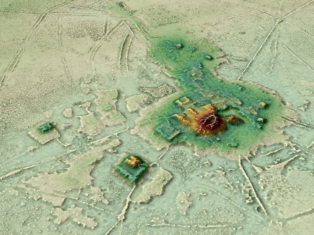
Photo: H. Prümers / DA. A 3-D animation put together using data from lidar shows the urban center of Cotoca, a lost city in the Amazon.
Today’s story is about a section of the Amazon that, thanks to new aerial studies, is starting to reveal long-hidden secrets.
Brian Handwerk reports at the Smithsonian that mapping technology has “cut through the canopy to detect sprawling urban structures in Bolivia that suggest sophisticated cultures once existed.
“The Amazon is one of the planet’s last great wildernesses, but legends have circulated for centuries that lost cities existed deep within the forests. A search for El Dorado, a supposed city of gold, lured many Spanish explorers far off the map and some of them never returned. …
“Now the plot has taken a new twist, as scientists have discovered that ancient cities really did exist in the Amazon. And while urban ruins remain extremely difficult to find in thick, remote forests, a key technology has helped change the game.
“Perched in a helicopter some 650 feet up, scientists used light-based remote sensing technology (lidar) to digitally deforest the canopy and identify the ancient ruins of a vast urban settlement around Llanos de Mojos in the Bolivian Amazon that was abandoned some 600 years ago. The new images reveal, in detail, a stronghold of the socially complex Casarabe Culture (500-1400 C.E.) with urban centers boasting monumental platform and pyramid architecture. Raised causeways connected a constellation of suburban-like settlements, which stretched for miles across a landscape that was shaped by a massive water control and distribution system with reservoirs and canals.
“The site, described [last month] in Nature, is the most striking discovery to suggest that the Amazon’s rainforest ‘wilderness’ was actually heavily populated. … Co-author Heiko Prümers, of the German Archaeological Institute, [says that] ‘a lot of people didn’t want to see that there were archaeological sites here that merit exploration.’ …
“Michael Heckenberger, an anthropologist at the University of Florida, wasn’t involved in the research but has been studying urbanism in the pre-Columbian Amazon for nearly two decades. He notes that elements of the settlement at Llanos de Mojos like moats and causeways, and a modified landscape of parklands, working forests and fish farms, have been seen elsewhere in the ancient Amazon.
“But the new research unveils something quite new. Previous examples of urbanism in the Amazon include the Upper Xingu region of the Brazilian Amazon where Heckenberger works with the Kuikuro Nation. Such settlements might be described as groups of villages networked together. They aren’t technically urban, some experts have argued, because they lack clearly defined larger centers, with monumental architecture like platform mounds and U-shaped temples.
“But those urban centers can be found at Llanos de Mojos. ‘This is in my mind the clearest case of a fully urbanized Amazonian landscape,’ Heckenberger notes. ‘It’s a marvelous piece of work.
‘It shows really remarkable range of things that humans did in the past to work with their landscapes and work with larger and larger populations.’
“Previous hands-on archaeological work and other remote-sensing efforts had revealed hundreds of isolated sites across more than 1,700 square miles of the Llano de Mojos region, including settlements inhabited year-round by the Casarabe, who hunted, fished and farmed staple crops like maize. Some 600 miles of causeways and canals had also been identified. But the logistical challenges of mapping them in a remote tropical forest hampered efforts to connect the dots and see if, or how, they were related to one another. …
“From an aircraft, a lidar system fires down a grid of infrared beams, hundreds of thousands per second, and when each beam strikes something on the Earth’s surface it bounces back with a measure of distance. This produces an enormous cloud of data points, which can be fed into computer software that creates high resolution images in which scientists can digitally deforest the Amazon. By scrubbing away trees the maps reveal the Earth’s surface and the archaeological features on it. In this case, the images clearly showed 26 unique sites, including 11 that were previously unknown. …
“Difficult as they can be to locate in the forest, earthworks clearly built by humans, designs known as geoglyphs, have been found in several other Amazon locales. In 2018, scientists using satellite images reported that large areas of Amazon forest in Brazil’s Mato Grosso state, once thought to have been sparsely inhabited at best, were dotted with villages and oddly-shaped earthwork geoglyphs. Even here, away from large rivers, many hundreds of villages could have housed up to a million people between 1250 and 1500 C.E. in an area that represents only about 7 percent of the Amazon basin. However if larger urban centers anchored these populated sites, they haven’t yet been identified. …
“The aerial view with trees stripped away revealed two centers, each anchored by a large network of regional settlements connected by numerous causeways. Those passageways radiate out from the centers like spokes on a wheel, and stretch for several miles. These connect sub-urban settlements, ranging from small settlements closer to the centers to more distant and even smaller sites that may have been used as temporary campsites. Similarly, canals also stretch from the main centers and connect to rivers and Laguna San José, which apparently delivered water to Cotoca.
“ ‘Basically they remolded the landscape in terms of their cosmology, which is mind blowing,’ says Chris Fisher, a Colorado State University Archaeologist not involved in the study who specializes in Mesoamerica. ‘The only problem is that this architecture was made from mud brick. So while at the time it was as fantastic looking as anything in the Maya region, the Maya monuments have endured because they had limestone while these just weren’t as durable.’ …
“Such discoveries of settlements were the result of very hard work. Despite the large and sophisticated populations that once thrived here, lasting evidence of urbanism has proven difficult to find in the remote and thickly forested Amazon. But lidar technology seems set to rapidly boost the pace of future discoveries.
“ ‘Lidar has been transformative for archaeology and this work is a great example of that,’ says Chris Fisher. ‘These researchers were able to see patterning that’s just not visible from the ground, and that pattern clearly showed two very large settlements, embedded within a settlement system, with a level of social complexity that really hasn’t been demonstrated very well in the Amazon,’ he says. ‘It’s absolutely amazing.’
“While it appears that the Amazon once teemed with human activity, many ancient sites have remained almost undisturbed for some 500 years, something Prümers cites as a big advantage. ‘The region has very low population density, and that means that we are finding the relics of pre-Spanish cultures over there almost untouched,’ he says.
“But the Amazon is changing rapidly. Forests are being eliminated to promote farming, ranching, energy production and the roads and dams that support such efforts. Many of those undisturbed areas, with their hidden records of past cultures, won’t remain so for long. Fisher advocates for large scale lidar scanning of the Amazon, and far beyond, through an Earth Archive project aimed at capturing what remains of the past before it’s lost to the future.
“ ‘We’re running out of time because we’re losing the Amazon,’ he says. ‘And we’re going to lose things that we never knew were there. To me that’s a real tragedy.’ ”
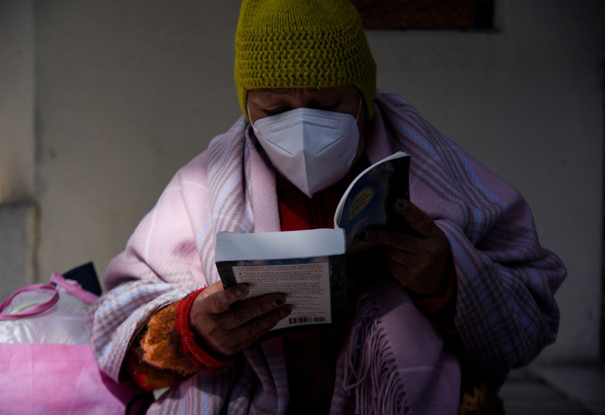
Photo: Reuters. An inmate reads the Bible in prison, where she and fellow inmates have access to a small library as part of a La Paz, Bolivia, program to spread literacy and offer the chance to get out of jail earlier.
Sharing stories like today’s, I can see why someone could accuse me of being a Pollyanna. But it’s not that I think people convicted of crimes will be completely transformed if shown a little kindness. It’s more that I see no harm in testing how small kindnesses might add up, especially for people who may have experienced few kindnesses.
In 2017, Philip Reeves at National Public Radio conducted an interview in a Brazil prison about a program that Bolivia is now testing.
“Brazil’s prisons are dangerous places,” Reeves, noted, “blighted by overcrowding and drug gangs. But literacy is offering a way to shorten some inmates’ sentences: Read books, reduce your time behind bars. …
“REEVES: About 30 men are sitting behind desks in a classroom. They’re writing with pens and paper. The teacher is standing up front issuing instructions. … We could be in any school anywhere but for a couple of details. One, a wall of iron bars separates the teacher from her class. Two, the paper each man’s writing could win him a little bit of his life back. … These are inmates in a giant penitentiary in southern Brazil called the Casa de Custodia de Piraquara. …
“MARILDA DE PAULA SOARES: (Through interpreter) I am an educator. I really believe people can change.
“REEVES: Marilda de Paula Soares is the class teacher. Her students are participating in a project pioneered by the southern Brazilian state of Parana. Prisoners get four days lopped off their sentences for each book they read. To get those days of freedom, they must write a short paper about the book. They’re doing that now. Soares says each prisoner’s paper must explain …
“SOARES: (Through interpreter) … what’s caught their eye, a specific character, the language, the theme …
“REEVES: … in sufficient detail to ensure that cheating is … impossible. Douglas Seixas, an inmate here, says it’s true. You really can’t skip the reading. …
“SEIXAS: Because we need to read a book to understand. If you not read the book, no, no way.
“REEVES: Only certain books qualify under the reading program, including foreign and Brazilian classics and kids’ books for prisoners learning to read. Books with very violent themes are banned. … There’s a maximum of 12 books a year. That adds up to a month and a half remission. Admilson Rodrigues is doing 10 years for drug trafficking but is steadily whittling down his sentence by reading. … Rodrigues said he loved Gone With The Wind and also Les Miserables. Les Miserables seems particularly popular here. Rodrigues believes that’s because it’s about an ex-con who’s trying to create a new life on the outside. …
“REEVES: Is this project window dressing by Brazilian officials? Are they trying to put a gloss on a dysfunctional penal system where inmates sometimes wait years before being tried? It’s hard to know. Yet, prisoners here do seem to be benefiting. Edson Reinehr says he’s on his fourth book, which is about the adventures of Mowgli the wolf boy.
“EDSON REINEHR: Helps a lot because to keep the mind — occupied mind inside the cell instead of thinking about other bad things.
“REEVES: Staff here say the project’s about much more than just helping prisoners pass the time and get a little remission. Teacher Agda Ultchak says it’s about fundamentally changing lives.
“AGDA ULTCHAK: (Through interpreter) We hope to create a new perspective on life for them. This is about acquiring knowledge and culture and being able to join another universe.”
Meanwhile, at Reuters, Monica Machicao reports on a version of the program that was launched recently in Bolivia.
“The state program ‘Books Behind Bars’ offers detainees a chance get out of jail days or weeks in advance of their release date.
Bolivia does not have a life sentence or death penalty, but pre-trial detention can last for many years due to a slow judicial system.
“The program has been launched in 47 prisons that do not have resources to pay for education, reintegration or social assistance programs for prisoners, the Andean country’s Ombudsman’s Office says.
“So far, 865 inmates are sifting through prose, improving their reading and writing skills. One of them is Jaqueline, who has already read eight books in a year and has passed four reading tests.
” ‘It is really hard for people like us who have no income and who do not have family outside,’ she said. ‘There are people here, for example, who are just learning how to read and write.’ …
“With a daily salary of 8 bolivianos ($1.18), incarcerated Bolivians are forced to work to be able to eat and pay the high court costs to be released. The country’s prisons and jails have long suffered from overcrowded and unsanitary conditions, with some detainees staging protests over the lack of health care, according to Human Rights Watch. …
“Said Mildred, an inmate at the Obrajes women’s prison in the highland city of La Paz, ‘When I read, I am in contact with the whole universe. The walls and bars disappear.’ “
More on Brazil’s program at NPR, here, and on Bolivia’s at Reuters, here.
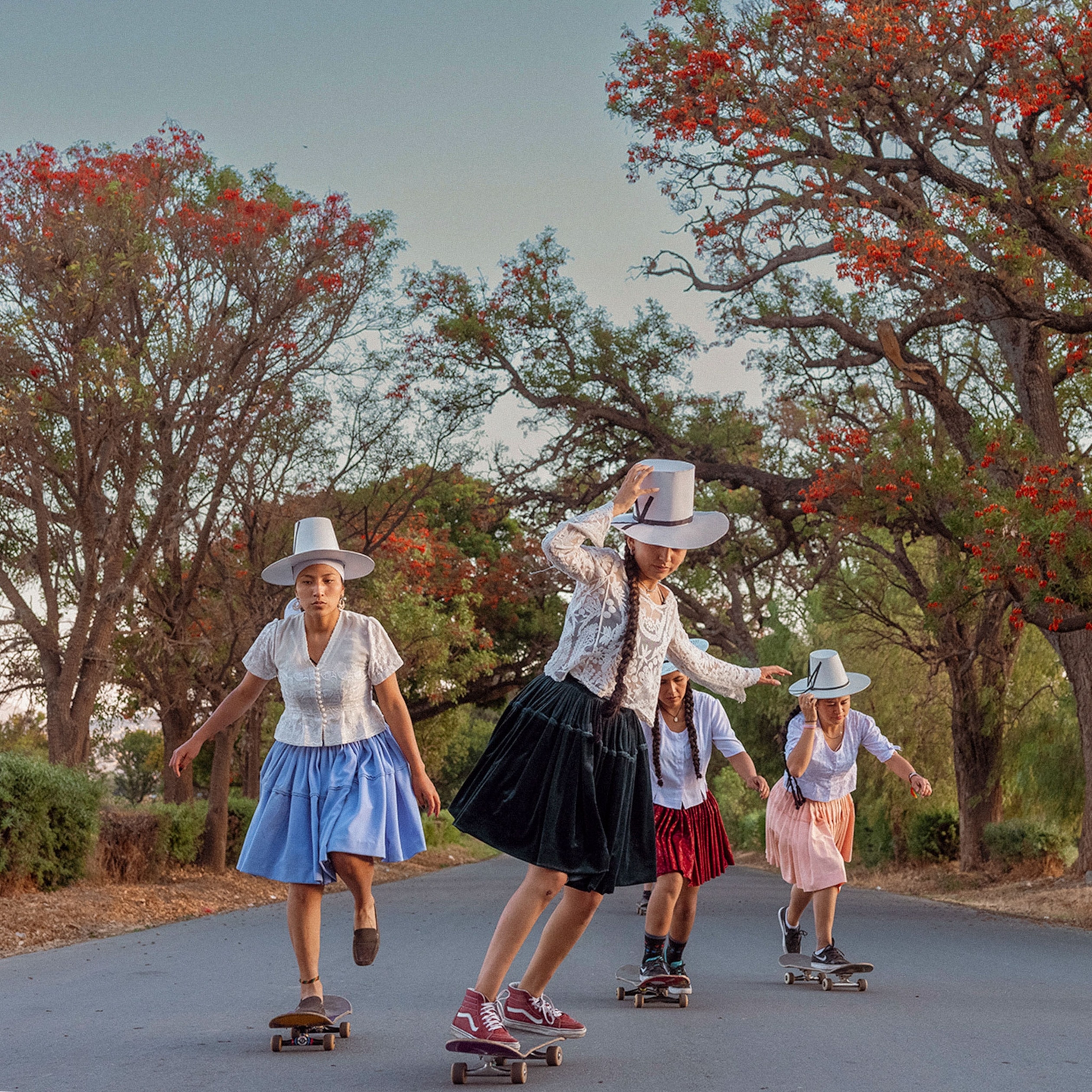
Photo: Luisa Dörr. ImillaSkate athletes practice skateboarding on a downhill road near Cochabamba, Bolivia. They use indigenous attire as a statement against discrimination.
We loved the movie Skate Kitchen about female skateboarders in New York. You may have seen my post about it here. Learning how outsiders find their people, their tribe, was a revelation.
My Cousin Claire knows I love stories like that. I think my whole extended family does. Maybe it’s in our DNA. Claire sent me today’s story about female skateboarders in Bolivia and the reasons they are using their sport to stick up for indigenous people.
Paula Ramón writes at National Geographic, “The colorful polleras are a symbol of identity in the Bolivian countryside. But these voluminous, traditional skirts worn by Indigenous Aymara and Quechua women have also been the object of discrimination, some seeing the appearance at odds with modern identity. Now a group of women athletes has brought them back to the city — donning them during skateboarding competitions — to celebrate the cultural heritage of the cholitas.
” ‘The pollerasare very valuable to me,’ says Deysi Tacuri López, 27, a member of ImillaSkate, founded in 2018 in Cochabamba, Bolivia’s third largest city. ‘I wear them with pride.’
“Tacuri sees in the polleras not only a cultural expression but also a form of empowerment. … More than half of Bolivia’s population is of Indigenous descent.
“Tacuri and fellow members at ImillaSkate also among those with Indigenous ancestors. Some of their relatives still wear polleras.
“ ‘They are my mother’s and my aunts’ clothing, and I see them as strong women. Here in Bolivia, many women in pollerasare the head of their families,’ she said in a telephone interview. ‘For me, mujeres de polleras [pollera wearers] can do anything.’
“Tacuri and her teammates spend long hours practicing moves at Ollantay Park, one of two places in the city with ramps and other structures designed for the sport. …
“ImillaSkate was founded by Daniela Santiváñez, 26, and two friends. She learned to skate as a child thanks to her brother, though it was ‘rare to see girls on skateboards.’ …
“Without women role models to follow in the sport in Cochabamba — and growing tired of listening to her mom’s complaints about her bruises from falls — Santiváñez stopped practicing when she was a teenager. She took up skateboarding again after college, where she got a degree in graphic design. By then, Dani, as her friends call her, discovered she was not the only woman with a passion for the sport.
” ‘One day I was having a conversation with the girls about why all the boys get together to skate — why don’t girls do that?’ recalls Santiváñez. …
“Over the past three years, ImillaSkate has grown to nine skaters. Being an active member means making time to practice every week in order to be able to participate in competitions, and also sharing the same principles of acceptance of diverse groups and traditions. Although the collective is based in Cochabamba, the group has generated a wider audience on social media beyond Bolivia, with more than 5,000 followers on Instagram. They also maintain a Facebook page with more than 7,000 followers, and a YouTube channel where some of their videos get thousands of views.
“Santiváñez clarifies that they wear the skirts only for performances, not necessarily as their street clothing. ‘We do it as a demonstration, as a cry for inclusion,’ she says. … ‘Skateboarding is inclusive, it brings all kinds of people together. …
‘It’s a community, and we’ve taken advantage of this to make the world a kinder place.’
“Tacuri says they first challenged themselves to embrace their own roots. ‘We ourselves have decided to get to know our culture and our identity. We have decided to revalue our clothing and encourage new generations.’ …
“The polleras’ origins date back to the Spanish conquest in the 16th century. Orginally imposed by colonial rulers as a way to easily identify the native population and also have the attire conform to what was being worn in Spain by the poorer people, the skirts eventually were adapted as part of traditional Andean attire, most commonly associated with cholas — Indigenous women from the highlands. Just as their ancestors gave the skirts their own identity by mixing them with patterned blouses, local jewelry, and hats, the skateboarding imillas are making their own modifications to the garment — and trying to remove a stigma.
” ‘The pollera is associated with the countryside, with ignorant people without resources. We want people to understand that there is nothing wrong with wearing a pollera.’ …
“The group didn’t even know where to get the elaborate skirts, so they turned to their grandmothers for help.
“Not all of them jumped on board immediately, concerned they would be stigmatized. Even as the descendant of a mujer de pollera, Luisa Zurita struggled with getting her family to understand the premise behind the wardrobe. Only after she was invited to participate in a local television program for a skateboarding performance did her grandmother give Zurita her blessing — and her favorite pollera.”
More at National Geographic, here. As you would expect of National Geographic, the photos are terrific.
Image: Casto Vocal Virtual reconstruction of northernmost section of pre-Incan temple in Bolivia.
Here’s why a general education may equip the workforce of the future better than job-specific training: you never know what skills will be needed. In this example, a new breed of adaptable archaeologist is expanding the use of 3-D technology to reimagine lost worlds.
George Dvorsky writes at Gizmodo, “The 1,500-year-old Pumapunku temple in western Bolivia is considered a crowning achievement of Andean architecture, yet no one knows what the original structure actually looked like. Until now.
“Using historical data, 3D-printed pieces, and architectural software, archaeologist Alexei Vranich from UC Berkeley has created a virtual reconstruction of Pumapunku — an ancient Tiwanaku temple now in ruins. Archaeologists have studied the site for over 150 years, but it wasn’t immediately obvious how all the broken and scattered pieces belonged together. The surprisingly simple approach devised by Vranich is finally providing a glimpse into the structure’s original appearance. Excitingly, the same method could be used to virtually reconstruct similar ruins. The details of this achievement were published [last December] in Heritage Science.
“First, some background on the structure. Pumapunku, which means ‘door of the puma,’ was a temple designed and built by the pre-Incan Tiwanaku culture, who lived and thrived in what is now western Bolivia from 500 AD to 1,000 AD. …
“Pumapunku displayed a level of craftsmanship that was largely unparalleled in the pre-Columbian New World, and it’s often considered the architectural peak of Andean lithic technology prior to the arrival of the Europeans. …
“Unfortunately, the ruins of Tiwanaku, and the Pumapunku temple in particular, have been ransacked repeatedly over the past half-millenium. Archaeologists have virtually no idea what the structure actually looked like. None of the blocks that once comprised the original structure are currently located in their original place, and many of them are badly damaged or decayed. …
“To overcome these difficulties and limitations, Vranich and his colleagues integrated historical archaeological data with modern computer software and 3D-printer technology to reconstruct the ancient temple, and by doing so, devised an entirely new approach to reconstructing and visualizing ancient ruins that would otherwise be impossible to build.
“The team created miniature 3D-printed models, at 4 percent actual size, of the temple’s 140 known pieces, which were based on measurements compiled by archaeologists over the past 150 years and Vranich’s own on-site observations of the ruins. … The researchers could have performed this work exclusively in the virtual realm, but they had better luck with tangible, physical pieces they could freely move around.
“ ‘It was much easier to use the 3D-printed models,’ Vranich told Gizmodo. ‘You can quickly manipulate them in your hand and try position after position. It is much slower and less intuitive on the computer.’ …
“Satisfied with their Lego-like configurations, the researchers keyed their creations into an architectural modeling program, culminating in a single hypothetical model of the temple complex. This wasn’t terribly difficult, as the construction methods used by the Tiwanaku people, and how they formed their incredibly geometric stones, are well documented, explained Vranich. But the exercise yielded some new findings.
“ ‘What we found out is that it appears they were making prototypes for each type of stone type, and then would have copied one after the other. It’s almost like it was a pre-Columbian version of Ikea.’ …
“Another interesting finding was that the gateways scattered around the site were lined up in a way to create a mirror effect. That is, ‘one big gateway, then another smaller one in line, then another,’ he said. ‘It would create an effect as if you were looking into infinity in the confines of a single room.’ ”
In Bolivia, an indigenous woman who would have been disenfranchised before the presidency of Evo Morales has become a popular wrestler. And she loves what she does.
Asa Merritt connects with Angela La Folklorista in La Paz to report her story at WBUR’s Only a Game.
“She calls herself, ‘Una mujer de la pollera.’ Woman of the skirt. That’s another way of saying ‘I’m a cholita.’ Cholitas are indigenous women of Bolivia, usually ethnically Quechuan or Ayamaran. You can recognize cholitas by their ankle-length puffy skirts and their tiny bowler hats, which seem like they’ll fall off any minute. …
“Until recently, cholitas were second-class citizens, boxed out from higher education and often stuck cleaning homes,” generally relegated to the kitchen.
“Where Angela works is nothing like a kitchen.
” ‘In the ring,’ Angela says in Spanish, ‘I have a technical fighter style. I’m not rough. I’m on the nice side. There are bad cholitas, as you would call them, but my style is technical.’
“Angela is a cholita luchadora — a Bolivian pro-wrestler. She fights in a league similar to Lucha Libre in Mexico or the WWE in the United States. It’s the kind of wrestling with heroes and villains, entrance songs. Angela gives me two ringside tickets for the upcoming bout in El Alto – La Paz’s sister city. She’s the headliner. …
“Angela doesn’t fight other women. She fights the men. There’s some weird sexist stuff happening, but by the end of the match Angela is always the winner. …
“ ‘I’m very happy and content to have another night of fighting,’ she says in Spanish, ‘another night of art, adrenaline and strength, another night that I’m in the center of the ring, happy, doing what I like most.’ She’s covered in sweat.
“ ‘Mi madre es luchadora,’ Angela’s middle-school aged daughter Theresa says.
“ ‘It’s a pleasure for me that she’s a wrestler,’ Theresa says in Spanish, ‘I’m very proud of her, I’m her number one fan.’
“Theresa describes the cholitas luchadoras as one of the Seven Wonders of the World. But she doesn’t want her mom’s job. It’s too dangerous for her. And unlike the cholitas who came before her, Theresa can choose her own dream.”
Azzurra Cox at the Atlantic‘s City Lab website wrote recently about design students and a nonprofit theater group that “created a ‘park-in-a-cart’ to serve the fast-growing city of El Alto, Bolivia.
“One bright July afternoon in El Alto, Bolivia, a playground paraded across a busy intersection.
“In the country’s second-largest city—and, at approximately 13,500 feet, the highest major urban settlement in the world—desfiles are a frequent occurrence, even a way of life. …
“But this parade was different. Dodging a stream of minibuses, a few individuals wearing carnivalesque costumes tugged two colorful metal carts—one resembling an astroturf bee, the other an elephant—to the center of a nearby plaza.
“Working in the harsh sunlight, they set about disassembling the carts. The shell of the bee became a series of green mounds, while the elephant trunk revealed itself as a slide.
“In a matter of minutes a playground was born, and the sounds of children playing rippled across the plaza. …
“In this dense city, driven by commerce at all scales, streets, sidewalks, and communal spaces are often transformed into informal markets, where vendors and minibuses compete for real estate. While this competition brings vitality, it requires novel methods of occupying urban space for play.
“The pop-up playground aims to do just that. Over three summers, the International Design Clinic (IDC), a ‘guerrilla design’ collective, has collaborated with Teatro Trono to design and build a pair of mutable, movable playspaces …
“Toward the end of that July afternoon, the park collapsed its way back into the carts. As one mother convinced her five-year-old to take her last turn down the slide, she asked one of the designers where she could find the playground next. Megan Hoffman, who studied anthropology at Temple University, recalls a grandmother who offered the group a sleeve of crackers to express her gratitude.
“ ‘That day,’ Hoffman says, ‘our pop-up playground was a space of joy.’ ”
The Associated Press had a story not long ago about some energetic Bolivians competing at handball.
“A group of Bolivian grandmothers and great-grandmothers have a pretty nontraditional way of easing the aches and pains of old age. These Aymara women get together every Wednesday in the city of El Alto and play handball.
“The ‘awichas,’ as grandmothers are known in the Aymara language, don sports jerseys over their traditional skirts and look forward to meeting and exercising with friends every week. …
“Team handball is an Olympic sport; two teams pass a ball using their hands to throw the ball into the opposite team’s goal.
“The handball team is part of a program where about 10,000 older people are practicing sports and playing Andean music; they also get free medical care.”
See some great great quotes and photos at NBC News, here.
Photo: Juan Karita/AP
In this Feb. 4, 2105 photo, 72-year-old Aurea Murillo prepares to make a pass during a handball match among elderly Aymara indigenous women in El Alto, Bolivia.