
A new fad: using the mapping function on your phone to create art.
At the New York Times, Claire Fahy has a report on a hobby generating the kind of puzzled glances that Pokémon enthusiasts wandering through traffic used to elicit.
“In 1665,” she begins, “Johannes Vermeer dabbed the last drop of paint onto a canvas in his Dutch studio, completing his masterpiece ‘Girl With a Pearl Earring.’
“On an April day 357 years later, Janine Strong slowed her bike to stop, paused her fitness app, and watched as the snaking line of her cycling route drew the shape of Vermeer’s masterpiece over the streets of Brooklyn.
“Ms. Strong creates what has come to be known as ‘GPS art’ — a practice that uses the Global Positioning System mapping capabilities of modern phone apps like Strava to create digital drawings using an athlete’s route across the landscape.
“Instead of biking on a straight path or in circles around a park, Ms. Strong plans her rides in the shapes of birthday cakes, stars, birds, lions — and the occasional Vermeer.
“The hobby has grown with the widespread availability of satellite tracking for use by ordinary people, in fitness apps like Nike Run Club or MapMyRide. It is particularly popular on Strava and often referred to as ‘Strava art.’
“Strava art has existed since that app’s release in 2009, but it experienced a surge in use during the pandemic. According to Michael Joseph, a senior communications manager at the company, more than three billion activities have been uploaded to Strava since the beginning of 2020.
“To complete her digital vision of ‘Girl With a Pearl Earring,’ Ms. Strong biked almost 50 miles around southern Brooklyn, carefully checking Strava to make sure each turn, circle, and straightaway was achieving the iconic earring and head covering of Vermeer’s original.
‘I always have a big smile on my face when it works out and I upload it and it’s done,’ she said. ‘It’s a very satisfying feeling.’ …
“In 2003, the New York Times Magazine ‘Year in Ideas‘ issue told of how Jeremy Wood and Hugh Pryor used Garmin GPS devices that looked like walkie-talkies to trace routes resembling butterflies and fish on walks through the English countryside.
” ‘It’s not just walking; you’ve got to be looking at this device,’ Mr. Pryor said in a recent interview. ‘People always wonder what you’re doing.’
“Mr. Wood said he got the idea for GPS art while he was using a GPS tracker on a flight and the plane flew in a holding pattern above Heathrow Airport. He was captivated by the pattern appearing on his Garmin.
“ ‘It formed this most beautiful oval shape, and it was better than I could draw by hand,’ Mr. Wood said. ‘That’s when I made a connection: You could use one’s movements to make marks in space.’
“Mr. Pryor, a classmate of Mr. Wood’s, had to develop software to get the GPS points off the Garmin and onto a computer, turning the data into drawings. In the years since, technology has advanced enough to create visual maps in real time using a phone or smart watch. …
“The practice has spread from the fields of Oxfordshire in England to the sand dunes of Rio Grande do Norte in Brazil. Gustavo Lyra has run around Rio Grande in the image of John Lennon’s face and spent almost nine hours running a route for his daughter’s fifth birthday. It was an image of Elsa from Disney’s Frozen. …
“Gene Lu, who lives in New Jersey, started creating GPS art when he became a fan of the Game of Thrones TV series in 2013. He ran the shape of the family crests from the program. …
“Lenny Maughan, who refers to himself as a ‘human Etch A Sketch,’ also started out making map art tied to pop culture. Leonard Nimoy — Mr. Spock in the original Star Trek — had just died in 2015, and Mr. Maughan decided to pay him tribute. … ‘I thought, OK, I’m going to do the Vulcan salute.’
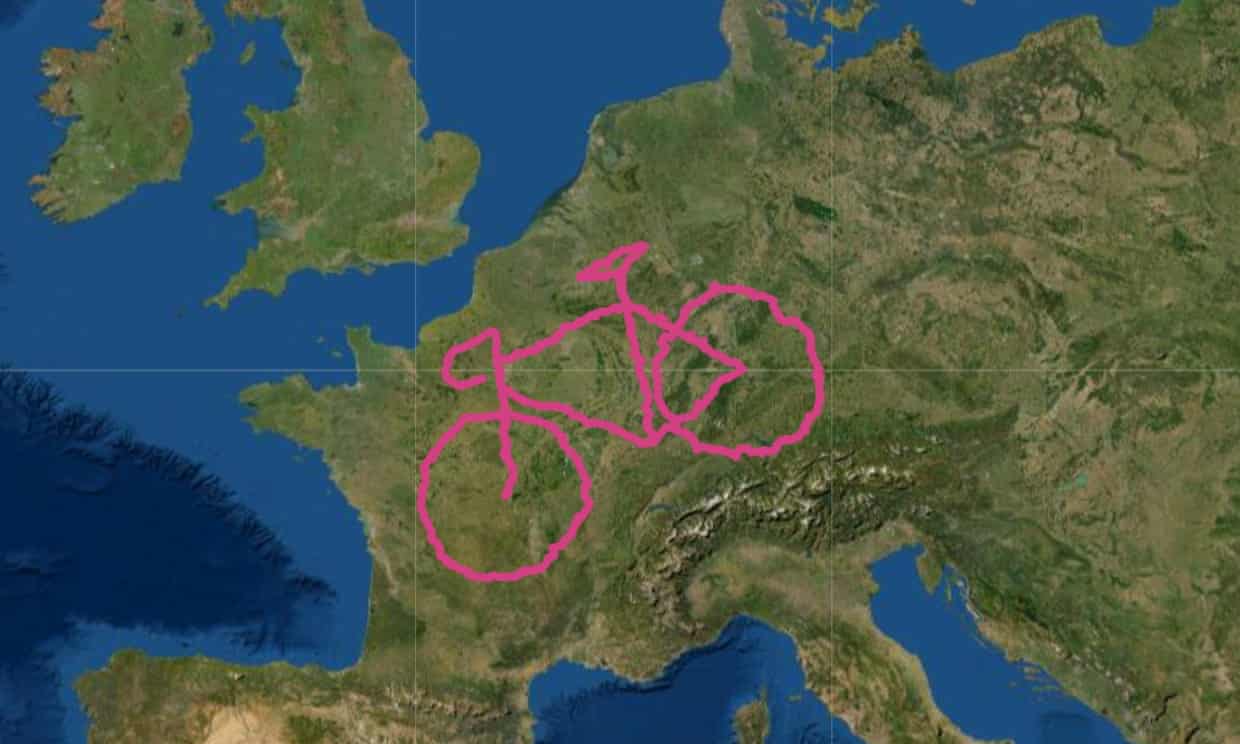
“The art form even has its own Guinness World Records categories. The Guardian profiled a couple who completed a 4,500-mile bike ride across Europe (while blogging the journey) that resulted in a 600-mile-wide GPS drawing of a bicycle — the largest such drawing on record, according to the Guardian. …
“For Mr. Lu, the unexpected is part of the beauty.
“ ‘The crazy thing is that you sort of don’t know where the map takes you; you just go with it,’ Mr. Lu said. ‘I always end up with what I’m looking for.’ “
More at the Times, here.
Photo: Daniel Rayneau-Kirkhope/Arianna Casiraghi.
The virtual bicycle drawn by Daniel Rayneau-Kirkhope and Arianna Casiraghi is 600 miles across and covers seven countries. See the article at the Guardian.


Fun!
>
LikeLike
Would you ever try it?
LikeLike
Fun! But phew what a lot of work.
LikeLike
So interesting to think of all the challenging activities that seem like too much work to most of us and like fun to a few. Like climbing Mt Everest, say, or writing a fantasy series!
LikeLiked by 1 person
😉
LikeLike
Sounds like a good hobby, as long as everyone looks before crossing the street, rather than at their phone.
LikeLike
That was the issue with the Pokémon virtual reality craze. It seems to have petered out.
LikeLiked by 1 person