Feeds:
Posts
Comments

Posts Tagged ‘excavation’

Photo: Alessandra Benini.
The ruins of Aenaria were buried in the sea for nearly 2,000 years, preserved underneath volcanic sediments.

Today’s story is about finding Aenaria, a Roman port that disappeared under the sea after a volcano erupted. Eva Sandoval at the BBC begins by describing a tour you can take there if you are interested in archaeology.

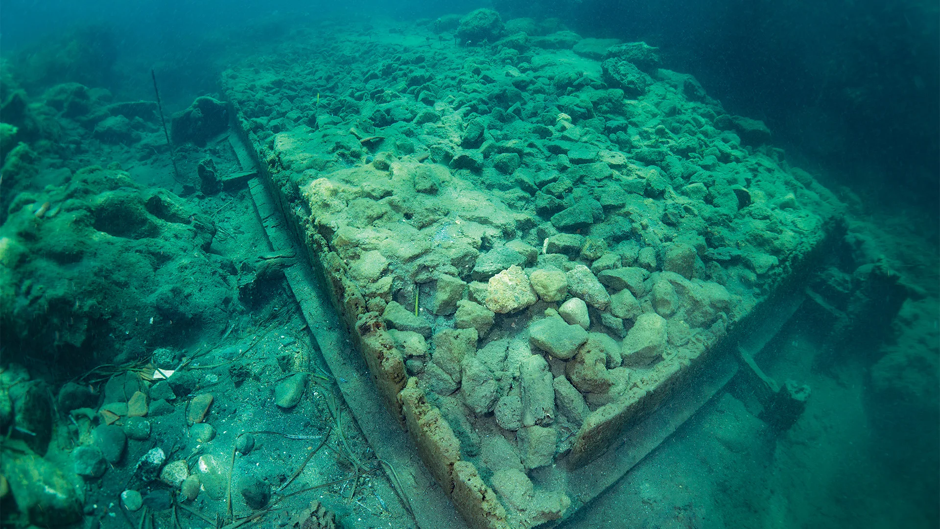
“As our tour sets sail, the vast Bay of Cartaromana opens up before us. Jagged cliffs shoot up from the waves; sunbathers sprawl on the inlet bridge leading to the 2,500-year-old Aragonese Castle. … After just 10 minutes at sea, we reach a network of buoys marking the ruins below. I press my hands against the vessel’s transparent bottom. Through the turquoise-blue water, between waving fields of seagrass and small striped fish, I glimpse a pile of rocks. Then the seagrass parts and I see that the rocks are arranged into a long rectangular form, its sides encased in wooden planks. This is an ancient city’s quay; buried in the cool dark for centuries and perfectly preserved. …

“I am on the Italian island of Ischia, where sometime around AD180, the Cretaio volcano erupted, and the ensuing shockwaves sank the Roman port city of Aenaria beneath the sea.

“At least, that’s what archaeologists think happened. … There are no records of the explosion, and very little written about the settlement itself. For nearly 2,000 years, there was no physical trace of it either. …

“The first hints of its existence were in 1972, when two scuba divers found Roman-era pottery shards and two lead ingots off Ischia’s eastern shore. The find intrigued archaeologists, but the ensuing investigation, helmed by local priest Don Pietro Monti and archaeologist Giorgio Buchner, yielded nothing. … The case went cold for nearly 40 years.

“Then, in 2011, passionate local sailors reopened the excavation, this time digging into the sea floor. Soon, they were able to confirm that 2meters beneath the bay’s volcanic seabed lay the ruins of a massive Roman-era quay. …

“As far as anyone had ever known, Ischia’s DNA was Greek. The island was renowned as the site of the first Greek colony in the Italian peninsula, established around 750BC in the north of the island. …

“When the Romans seized Pithecusae sometime around 322BC, they renamed the island Aenaria – a name that appears in ancient texts from Pliny the Elder to Strabo, often in relation to military events. But unlike the Greeks, who left behind a necropolis, kilns and troves of pottery, the Romans left only a few modest tombs, engravings and scattered opus reticulatum. …

” ‘The name was documented,’ echoes local resident Giulio Lauro. ‘But no one could find the place.’ Archaeologists had been looking for Roman Ischia on dry land, but it was buried below the sea.

“Lauro is the founder of the Marina di Sant’Anna; the cultural branch of the Ischia Barche sea-tourism cooperative. Along with various affiliated cultural groups – comprised of Ischian seafarers, history enthusiasts and archaeologists – they have self-funded the excavations for the past 15 years.

“Lauro is quick to tell me that he’s no scientist. ‘But I love the sea,’ he said. ‘In 2010, I got the idea to look again.’ …

“There were challenges, recalls Lauro: ‘Getting authorizations, training people, sourcing funds. We started from zero. We were lucky to believe in it. And then to actually find it.’ …

” ‘It was believed that the Romans never built a city on Ischia,’ says [Dr Alessandra Benini, the project’s lead archaeologist]. ‘It was the opposite.’ …

“Each summer, Benini and her team excavate the sea floor. Progress is painstaking due to a perennial shortage of funds. … During the site’s active months, curious visitors can take glass-bottomed boat tours, as well as snorkelling and scuba excursions to get even closer to the ruins. ‘You can see the underwater archaeologists at work, the equipment they use and everything involved,’ says Benini. …

“I ask Benini what she hopes to find this summer.

” ‘My dream is to find the foundations of the residential city,’ she says. ‘If we’ve found the port, then we know there was a city.’  

“The team hopes to introduce Lidar, Georadar and sub-bottom profiler instruments into the digs, but Benini points out, ‘That’s expensive. We need more investors.’ “

Lots more at the BBC, here. No paywall.

Read Full Post »

Photo: Jesse Casana.
Jonathan Alperstein, a researcher, excavates land on an unexpectedly large ancient agricultural site in Michigan.

The other day, my neighbor surprised me with a bunch of aerial photos of my New Shoreham place that were taken by her nephew’s drone. As drones are used more and more in warfare, I sure like thinking about the harmless and often useful things drones do.

In today’s example, a mystery revealed by drone led to a long-term collaboration between Menominee tribal members and non-Indigenous archaeologists in Michigan.

Nell Greenfieldboyce reports at National Public Radio (NPR), “Archeologists studying a forested area in northern Michigan say they’ve uncovered what is likely the largest intact remains of an ancient Native American agricultural site in the eastern half of the United States.

“The researchers used a drone equipped with a laser instrument to fly over more than 300 acres, taking advantage of a brief period of time after the winter snow had melted away but before the trees had put out their leaves.

“This allowed the drone to precisely map subtle features on the surface of the exposed ground, revealing parallel rows of earthen mounds. This is what’s left of raised gardening beds that were used to grow crops like corn, beans, and squash by the ancestors of the Menominee Indian Tribe of Wisconsin, in the centuries before European colonizers arrived.

“The mounds appeared to continue on beyond the surveyed area, the researchers say, showing agriculture at a surprisingly vast scale in a place that wasn’t a major population center.

” ‘We haven’t even been able to locate any significant settlement sites in this region. There’s a couple of tiny little villages,’ says Jesse Casana, a professor of anthropology at Dartmouth College and one of the authors of a new report in Science. ‘So it’s really shocking in this case to see this level of investment in an agricultural system that would require really enormous amounts of human labor to make happen.’

“It’s especially odd given the relatively poor growing conditions that far north, especially during a period of colder temperatures known as the Little Ice Age, as well as the presence of wild rice right nearby, says Madeleine McLeester, a Dartmouth anthropologist who led the research team. …

” ‘This astonishing paper shows how much we’ve underestimated the geographic range, productivity, and sustainability of intensive Indigenous agriculture across North America,’ says Gayle Fritz, an anthropologist with Washington University in St. Louis.

” ‘The study is outstanding in many ways, one being the long-term collaboration between Menominee tribal members and non-Indigenous archaeologists,’ she says — with the other being the combination of new technologies plus ‘old-fashioned, ground-based excavation and survey.’

“While some people may envision historical Native Americans as mostly hunter-gatherers or nomads, ‘that is very incorrect,’ says Casana. ‘By the time colonists arrived, what they were encountering were a lot of pretty sedentary communities all over North America who were practicing various forms of farming,’ he says. …

“The site mapped in this new study is part of Anaem Omot, which means the ‘Dog’s Belly’ in Menominee. It’s an area along the Menominee River on the border between Michigan and Wisconsin, and is of great cultural and historical significance to the Menominee tribe.

“The region contains burial mounds and dance rings. It’s also known to have agricultural ridges, ranging from 4 to 12 inches in height, because previous work back in the 1990’s had mapped some of them.

” ‘These features are really difficult to see on the ground, even when you’re walking around, and they’re difficult to map,’ says McLeester.

“That difficulty, plus concerns about proposed mining activities in the area, is why the research team — which included the tribe’s historic preservation director, David Grignon — wanted to see if new technology could reveal more acres covered with the earthen agricultural rows.

“McLeester says they thought they’d find some more rows, but also expected that others would have eroded away since the last mapping effort. …

“But the drone surveys revealed that the field system was ten times bigger than what had been previously seen. ‘Just the scale, I would say, was unexpected,’ she says. …

“Says Casana, ‘One of the interesting things about this study is that it kind of shows us a preserved window of what was probably a much more extensive agricultural landscape.’ …

Susan Kooiman of Southern Illinois University, an expert on the precontact Indigenous peoples of Eastern North America, says … ‘To find intact, ancient indigenous agricultural fields in any state, at any level, is very rare. …

” ‘The amount of work, and just how far these fields extend, is beyond anything that I think people suspected was going on this far north in eastern North America,’ she says. … ‘The question now is, what are they doing with all this stuff they were growing?’ “

More at NPR, here. (NPR is struggling since the massive federal cut. Help them out here if you can. No amount too small.)

Read Full Post »

Photo: J. Przedwojewska-Szymańska / PASI.
The head of the male figurine is decorated with tattoos or scarification. Made between 410 and 380 B.C.

Here’s a story to tickle the frustrated archaeologist in you. I say “frustrated” because I’m not aware of any actual archaeologists who follow this blog, but many of us find the mysteries of of the field fascinating.

Sonja Anderson wrote recently at the Smithsonian about the excavation in El Salvador of “puppets that resemble modern toy dolls” with movable parts. They look like humans, but creepier.

“Researchers have discovered a trove of ancient clay puppets at an archaeological site in El Salvador, ” Anderson reports. “The five carved figurines are about 2,400 years old, and they may help shed new light on an ancient Mesoamerican society.

Jan Szymański and Gabriela Prejs, two archaeologists from the University of Warsaw, discovered the artifacts atop a ruined pyramid at the site of San Isidro. As they write in a new study published in the journal Antiquity, the items are known as Bolinas figurines: rare puppet-like artifacts that have been found in other ancient Central American sites, such as the early Maya site Tak’alik Ab’aj in Guatemala.

“All of the recently discovered Bolinas figurines have open mouths. The two smallest puppets measure around four inches and seven inches, while the other three stand at about a foot tall. These larger figurines have detachable heads and small holes in their necks and craniums. As the researchers write, this allows for ‘a string to be passed through the neck and tied on the top of the head.’ …

“Compared with neighboring countries, El Salvador’s pre-Columbian history is poorly understood, according to a statement from Antiquity. Excavations are challenging due to the country’s high population density, and volcanic eruptions over thousands of years have damaged and buried archaeological sites.

“ ‘Very little is known about the identities and ethnolinguistic affiliations of the creators of ancient settlements that predate the arrival of Europeans in the early 16th century,’ Szymański says in the statement. ‘This gets worse the further back in time we look.’

“The San Isidro site is a complex of mostly clay structures built by an unknown group, and it remains largely unexcavated. The researchers found the Bolinas figurines while digging at the top of the site’s largest pyramidal structure. Through carbon dating, they’ve concluded the five figurines were made between 410 and 380 B.C.E. [Before Current Era].

“ ‘This finding is only the second such a group found in situ, and the first to feature a male figure,’ Szymański says in the statement. The male puppet sports what appear to be facial tattoos, and the other four are female.

“The researchers think that these versatile Bolinas figurines could have been used during ‘rituals that would involve recreation of some actual events or mythical events,’ Szymański tells IFL Science’s Benjamin Taub.

“ ‘In Mesoamerican thought, still visible today, to recreate something was to actually create it,’ he adds. ‘So if a ruler decided to commission a sculpture of himself, he was effectively cloning himself, allowing himself to look over his people even when he was away.’ …

“Figurines like these have been found in Guatemala and elsewhere in El Salvador, and jade pendants unearthed nearby resemble similar artifacts discovered in present-day Nicaragua, Panama and Costa Rica, per the statement. As such, the ancient inhabitants of San Isidro may have been connected to distant peoples.

“ ‘This discovery contradicts the prevailing notion about El Salvador’s cultural backwardness or isolation in ancient times,’ Szymański adds. ‘It reveals the existence of vibrant and far-reaching communities capable of exchanging ideas with remarkably distant places.’ ”

Reading this story, I kept thinking about a clay figure from a completely different culture, the golem. Wikipedia says the golem “is an animated anthropomorphic being in Jewish folklore, which is created entirely from inanimate matter, usually clay or mud. … In modern popular culture, the word has become generalized, and any crude anthropomorphic creature devised by a sorcerer.”

There must be something in human nature that needs to invent these creatures.

More at the Smithsonian, here. No firewall.

Read Full Post »

Photo: BBC.
A PhD student found a lost city by accident in eastern Mexico, in Campeche.

Talk about happy accidents! I’m sure we have all experienced a few, whether in cooking or driving around. And we often hear of happy accidents in science. Today, we learn about an alert PHD student who found an ancient civilization without precisely looking for one.

Georgina Rannard writes at the BBC, ” ‘I was on something like page 16 of Google search and found a laser survey done by a Mexican organization for environmental monitoring,’ explains Luke Auld-Thomas, a PhD student at Tulane university in the US.

“It was a Lidar survey, a remote sensing technique which fires thousands of laser pulses from a plane and maps objects below using the time the signal takes to return.

“But when Mr Auld-Thomas processed the data with methods used by archaeologists, he saw what others had missed — a huge ancient city which may have been home to 30,000-50,000 people at its peak from 750 to 850 AD. … Mr Auld-Thomas and his colleagues named the city Valeriana after a nearby lagoon.

“The find helps change an idea in Western thinking that the Tropics was where ‘civilizations went to die,’ says Professor Marcello Canuto, a co-author in the research. Instead, this part of the world was home to rich and complex cultures, he explains. …

It is ‘hidden in plain sight,’ the archaeologists say, as it is just 15 minutes hike from a major road near Xpujil, where mostly Maya people now live.

“There are no known pictures of the lost city because ‘no one has ever been there,’ the researchers say, although local people may have suspected there were ruins under the mounds of earth.

“The city [had] two major centers with large buildings around 2km (1.2 miles) apart, linked by dense houses and causeways. It has two plazas with temple pyramids, where Maya people would have worshipped, hidden treasures like jade masks and buried their dead. It also had a court where people would have played an ancient ball game. There was also evidence of a reservoir, indicating that people used the landscape to support a large population. …

“Professor Elizabeth Graham from University College London, who was not involved in the research, says it supports claims that Maya lived in complex cities or towns, not in isolated villages. …

“The research suggests that when Maya civilizations collapsed from 800 AD onwards, it was partly because they were so densely populated and could not survive climate problems.

” ‘It’s suggesting that the landscape was just completely full of people at the onset of drought conditions and it didn’t have a lot of flexibility left. And so maybe the entire system basically unravelled as people moved farther away,’ says Mr Auld-Thomas.

“Warfare and the conquest of the region by Spanish invaders in the 16th century also contributed to eradication of Maya city states.

“Lidar technology has revolutionized how archaeologists survey areas covered in vegetation, like the Tropics, opening up a world of lost civilizations, explains Prof Canuto. …

” ‘I’ve got to go to Valeriana at some point. It’s so close to the road, how could you not? But I can’t say we will do a project there,’ says Mr Auld-Thomas. ‘One of the downsides of discovering lots of new Maya cities in the era of Lidar is that there are more of them than we can ever hope to study,’ he adds.

“The research is published in the academic journal Antiquity.

More at the BBC, here. Seems to me the discovery was hardly an accident. Anyone with the patience to look at page 16 of a Google search deserves a bit more credit.

Read Full Post »

Photo: Eva K. via Wikimedia.
Herrerasaurus skeleton replica at a special exhibition of the Naturmuseum Senckenberg in Frankfurt am Main, the largest museum of natural history in Germany.

As we take in the horrendous flooding of two major hurricanes in the US this month, it’s hard to imagine that heavy rains and floods ever do anything beneficial. But last May in Brazil they added to human knowledge of dinosaurs, and that could be useful.

Eléonore Hughes wrote at the Associated Press, “A team of Brazilian scientists has discovered a fossilized skeleton of what they believe is one of the world’s oldest dinosaurs after heavy rains in the southern state of Rio Grande do Sul accelerated the natural process of erosion.

“The fossil found next to a reservoir in the municipality of Sao Joao do Polesine is [the oldest yet] according to paleontologist Rodrigo Temp Müller, who led the team from the Federal University of Santa Maria that found the bones in May. The claims have not been verified by other scientists or published in a scientific journal [as of this writing].

“The researcher believes the dinosaur lived during the Triassic period, when all continents were part of a single land mass called Pangaea. Dinosaurs are thought to have first evolved at that time.

“The apex predator discovered in Rio Grande do Sul belongs to the group known as Herrerasauridae — a family of dinosaurs that used to wander across lands that now make up present-day Brazil and Argentina, according to a fact sheet about the discovery shared with the Associated Press.

“The size of the bones reveals that the dinosaur would have reached around 2.5 meters (8.2 feet) in length, according to the document. …

‘Initially it seemed like just a few isolated bones, but as we exposed the material, we were able to see that we had an almost complete skeleton,’ Müller said. …

“Researchers will now try to determine whether the fossil belongs to an already known species or a new kind. That work is expected to take several months, as the process is meticulous to ensure no damaged is caused.

“Fossils are more likely to appear after rains, as water exposes the materials by removing the sediment that covers them, in a phenomenon known as weathering.

“Rio Grande do Sul saw record amounts of rainfall earlier this year. That caused devastating floods in May that killed at least 182 people, according to a toll published by the state’s civil defense on July 8. …

“Müller said that more fossils are appearing because of the heavy rains, which has launched a race against time to rescue the materials before they are ruined.

“In the field, his team observed ‘a leg bone and a pelvis bone in the pelvic region that were already being destroyed due to the rain,’ he said.”

More at APNews, here. If you’re keen on dinosaurs, check out the paleontologist’s diary of the excavation, here.

Read Full Post »

Photo: Tony Jolliffe/ BBC.
Newly uncovered frescoes in Pompeii depict Paris (of Troy) and his surprisingly peaceful kidnapping of Helen (of Greece) — the act that triggered the Trojan War.

Art from the ancient world can make you think twice about what you know. When you picture the Greek myth in which Paris steals the most beautiful woman in the world from her husband Menelaus, do you ever imagine her going quietly? I don’t. But judging from newly uncovered frescoes, people in Pompeii did. It puts a whole different cast on the Trojan Wars.

Jonathan Amos, Rebecca Morelle, and Alison Francis report at the BBC, “Stunning artworks have been uncovered in a new excavation at Pompeii, the ancient Roman city buried in an eruption from Mount Vesuvius in AD79.

“Archaeologists say the frescos are among the finest to be found in the ruins of the ancient site. Mythical Greek figures such as Helen of Troy are depicted on the high black walls of a large banqueting hall. …

“A third of the lost city has still to be cleared of volcanic debris. The current dig, the biggest in a generation, is underlining Pompeii’s position as the world’s premier window on the people and culture of the Roman empire. …

“It was likely the walls’ stark color was chosen to hide the smoke deposits from lamps used during entertaining after sunset. ‘In the shimmering light, the paintings would have almost come to life,’ [Park director Dr Gabriel Zuchtriegel] said.

“Two set-piece frescos dominate. In one, the god Apollo is seen trying to seduce the priestess Cassandra. Her rejection of him, according to legend, resulted in her prophecies being ignored. The tragic consequence is told in the second painting, in which Prince Paris meets the beautiful Helen – a union Cassandra knows will doom them all in the resulting Trojan War.

“The black room is the latest treasure to emerge from the excavation, which started 12 months ago – an investigation [featured] in a documentary series from the BBC and Lion TV … in April. …

“Staff are having to move quickly to protect new finds, removing what they can to a storeroom. For the frescos that must stay in position, a plaster glue is injected to their rear to prevent them coming away from the walls. Masonry is being shored up with scaffolding and temporary roofing is going over the top. …

“Excavations in the late 19th Century uncovered a laundry in one corner. The latest work has now revealed a wholesale bakery next door, as well as the grand residence with its black room. The team is confident the three areas can be connected, physically via the plumbing and by particular passageways, but also in terms of their ownership. The identity of this individual is hinted at in numerous inscriptions with the initials ‘ARV.’ The letters appear on walls and even on the bakery’s millstones.

” ‘We know who ARV is: he’s Aulus Rustius Verus,’ explained park archaeologist Dr Sophie Hay. ‘We know him from other political propaganda in Pompeii. He’s a politician. He’s super-rich. We think he may be the one who owns the posh house behind the bakery and the laundry.’

“What’s clear, however, is that all the properties were undergoing renovation at the time of the eruption. Escaping workers left roof tiles neatly stacked; their pots of lime mortar are still filled, waiting to be used; their trowels and pickaxes remain, although the wooden handles have long since rotted away.

“Dr Lia Trapani catalogues everything from the dig. She reaches for one of the thousand or more boxes of artifacts in her storeroom and pulls out a squat, turquoise cone. ‘It’s the lead weight from a plumb line.’ Just like today’s builders, the Roman workers would have used it to align vertical surfaces.

“She holds the cone between her fingers: ‘If you look closely you can see a little piece of Roman string is still attached.’

“Dr Alessandro Russo has been the other co-lead archaeologist on the dig. He wants to show us a ceiling fresco recovered from one room. Smashed during the eruption, its recovered pieces have been laid out, jigsaw-style, on a large table.

“He’s sprayed the chunks of plaster with a mist of water, which makes the detail and vivid colours jump out. You can see landscapes with Egyptian characters; foods and flowers; and some imposing theatrical masks.

” ‘This is my favorite discovery in this excavation because it is complex and rare. It is high-quality for a high-status individual,’ he explained.”

At the BBC, here, read that there’s a dark side to what they’re finding. No paywall.

Read Full Post »

Photo: Michigan State University Archives via the Smithsonian.
Michigan State University’s first observatory, circa 1888. 

Sometimes it’s just luck that starts someone on a rewarding career — or generates a lifetime of memories. Today’s story is about the trajectory of budding archaeologists.

Daniel Wu writes at the Washington Post, “Morgan Manuszak had to travel thousands of miles from her East Lansing, Mich., campus in 2022 to get some much-needed work experience. The Michigan State University senior, who studies archaeology as part of a minor in anthropology, said she was able to do archaeological fieldwork for the first time only in Isthmia, Greece, where the university hosts a field school.

“Not every budding archaeologist at Michigan State is so fortunate, students and researchers said. Opportunities for students to complete archaeological fieldwork are competitive and often require expensive overseas travel. Many students were also unable to access such trips during the pandemic, when travel was restricted.

“But soon, a new archaeological site will be waiting for the university’s undergraduates just a short walk from their dorms.

“Students working with Michigan State’s Campus Archaeology Program this summer unearthed part of the cobblestone foundation of a 142-year-old observatory in a clearing near a student residence hall, the university announced [in August]. The site of the building — Michigan State’s first observatory for astronomy, dating back to 1881 — will become a dig site next summer for the university’s undergraduates and local residents to practice archaeological techniques right on campus.

“The unlikely discovery happened this summer when construction workers attempted to install hammock poles near a student residence hall on the north end of campus, said Stacey Camp, director of the Campus Archaeology Program. They contacted the program after hitting a hard surface while trying to drive the poles into the ground.

“Researchers consulted school records and noticed that the unassuming site — a lawn shaded by leafy trees near picnic benches and a basketball court — was near the location of a century-old facility built during a key period of change for the university. Michigan State, originally an agricultural college, was slowly branching out into other fields when a professor built the observatory in 1881. …

“The observatory housed a telescope and some of the university’s early astronomy classes and was probably demolished in the 1920s, said Ben Akey, a PhD student and campus archaeologist at Michigan State.

“Akey and a team of students, including Manuszak, conducted an initial survey at the location in June, digging a grid of small holes to try to find remnants of the observatory. They dug for weeks without luck in the area where the construction crew had been working until, on the last scheduled day of searching, a shovel finally struck a small stretch of cobblestone and mortar.

“ ‘It’s a weird common occurrence in archaeology,’ Akey said. ‘Just as you’re about to move on from a site, you end up finding something that sticks you there for another few weeks.’

“Further excavation confirmed that the rock border was the foundation of the old observatory, to the excitement of Akey, Manuszak and the rest of the team. …

“ ‘It was really, really fulfilling,’ Manuszak said. …

“The Campus Archaeology Project has conducted additional research on the site since June, including a scan using ground-penetrating radar, but the bulk of the work is being saved for the university’s undergraduates.

“Some of those students have been starved for an opportunity like this, Akey and Manuszak said. The Campus Archaeology Project has conducted digs and partial excavations at other locations on campus, but the observatory will be one of the university’s oldest excavation sites. That makes a difference in a competitive field where job opportunities hinge on hands-on experience, Akey said. …

“ ‘You can sit in a classroom and learn the steps of how you’re going to lay out your grid and how you need to take note of your stratigraphy as you’re digging down for your excavation unit,’ Manuszak said. ‘But you don’t really get a feel for it until you’re doing it.’ “

More about getting hands-on experience at the Post, here. Also at the Smithsonian, where there is no paywall.

Read Full Post »

Photo: National Park Service.
Archeological excavation at an integrated community founded by a former slave in Illinois.

One thing that’s interesting about today’s story is that political differences have been set aside in the restoration of an abandoned town founded by a former slave.

Mark Guarino reports at the Washington Post, “As a child, Gerald McWorter often listened to his father tell stories about growing up on a farm in New Philadelphia, Ill. But it wasn’t until a family reunion in 2005 that he fully understood the significance of his lineage: Everyone he met that day was in some way affected by the story of his great-great-grandfather, a formerly enslaved man from Kentucky who in 1836 became the first Black person in the United States to plat and register a town.

“During Frank McWorter’s time, New Philadelphia thrived as a community where Black and White families worked together as equals long before the Civil War was fought to preserve — or destroy — that possibility.

“The revelations have emerged through three decades of archaeological digs, advocacy by local community members, oral histories and family artifacts, letters and research. The momentum was enough to convince Gerald McWorter, 78, that he and other relatives ‘had an obligation’ to ‘become stewards of a story that is bigger than us.’

“Also convinced was Rep. Darin LaHood (R-Ill.), who introduced a bill that would designate the site of New Philadelphia a part of the National Park Service. …

“Frank McWorter was born into slavery in 1777 and grew up on a Kentucky plantation. His White enslaver, George McWhorter, was also his father. Frank was an entrepreneur of sorts whose father allowed him to earn wages outside his hours of slavery in a cave where he foraged and sold materials used for gunpowder.

By 1817, Frank had saved enough money to buy freedom for his wife, Lucy, who was pregnant with their fifth child. Two years later, he was able to buy his own freedom.

“Emancipating 15 other family members would follow, a process that lasted through 1857 — three years after the death of Frank, who came to be known as Free Frank. …

“ ‘It’s often hard for people to get out of their heads that it would take 40 years to buy your family back from slavery. It’s a really heroic story that captured the imagination,’ said Gerald McWorter, a professor emeritus at the University of Illinois at Urbana-Champaign, where he taught African American studies.

“The first person in the McWorter family to actively document Frank’s life was Gerald’s aunt, Thelma McWorter Kirkpatrick Wheaton, who collected family documents, letters and photos as well as interviewed older descendants. Her daughter used that material to write her doctoral dissertation about Frank McWorter, and the University of Kentucky Press published it as a book in 1983.

“Frank McWorter’s dream included buying his own land, and he eventually purchased 80 acres, sight unseen, in Pike County, Ill., along the Missouri border. It was thick prairie then, and the McWorters arrived in 1831 to clear it for growing crops and constructing a town. Descendants of McWorter remained in the area until the late 1990s.

“New Philadelphia existed for half a century. Named after the eastern metropolis that symbolized brotherly love for all races, it was a prosperous frontier town that had a post office, a school, a store, a blacksmith shop and two shoemakers, presumably to supply footwear for runaway enslaved people who passed through on their way to Canada. The town was home to as many as 29 households, and neighboring farmsteads used its services.

“But what distinguished the community was where it was located: just 20 miles from Hannibal, Mo., a bustling river town that served as a major site for auctions of enslaved people. Just over the Mississippi River, African Americans were human chattel and subject to horrific violence, but in New Philadelphia, they freely owned guns, earned good livings and worked the land with their White neighbors. …

“The renewed interest in New Philadelphia began in 1996 after a community group formed to enshrine McWorter’s story on a sign at a rest stop along a state highway next to the cemetery where he is buried. Group founder Phil Bradshaw, a farmer and longtime Republican who is White, said that early on, he would receive ‘nasty notes and nasty comments’ from townspeople about the advocacy. Eventually, those subsided. …

“The community group, the New Philadelphia Association, bought more than 30 acres that Frank McWorter had owned and allowed archaeologists from the University of Illinois and the University of Maryland to dig over several summers to unearth remnants of the town. Although no original buildings remain, the area has walking trails with smartphone-enabled kiosks that tell McWorter’s story. …

“For Gerald McWorter, the integrated town his great-great-grandfather built gives him hope.

“ ‘If New Philadelphia was possible, maybe [racial harmony in] America is possible,’ he said.”

More at the Post, here.

Read Full Post »

Photo: Adrian Dennis/AFP/Getty.
As construction for a tunnel under Stonehenge begins, archaeological surprises are turning up.

Do you ever wonder about the layers of civilization buried deep beneath your feet? John Hanson Mitchell wondered about my region’s layers back in a 1980s book, here. He got himself into a kind of trancelike state in which he believed he could sense the presence of indigenous tribes living their lives beside what is now Interstate 495.

More recently, as Steven Morris reports at the Guardian, “Bronze age graves, neolithic pottery and the vestiges of a mysterious C-shaped enclosure that might have been a prehistoric industrial area are [being] unearthed by archaeologists who have carried out preliminary work on the site of the proposed new road tunnel at Stonehenge.

“One of the most intriguing discoveries is a unique shale object that could have been part of a staff or club found in a 4,000-year-old grave. Nearby is the resting spot of a baby buried with a small, plain beaker. Ditches that flank the C-shaped enclosure contain burnt flint, suggesting a process such as metal or leatherworking was carried out there thousands of years ago.

“Just south of the site of the Stonehenge visitor centre, archaeologists came upon neolithic grooved ware pottery possibly left there by the people who built the stone circle or visited it.

“ ‘We’ve found a lot – evidence about the people who lived in this landscape over millennia, traces of people’s everyday lives and deaths, intimate things,’ said Matt Leivers, A303 Stonehenge consultant archaeologist at Wessex Archaeology. …

“The plan to drop the A303, which passes close to the stones, into a two-mile tunnel is hugely controversial, with many experts having said that carrying out such intrusive construction work would cause disastrous harm to one of the world’s most precious ancient landscapes and lead to the loss of hundreds of thousands of artefacts. A legal challenge was launched against the £1.7bn plan late last year.

“Highways England and Wessex Archaeology, which is leading the exploration of the tunnel corridor, said they were working on the project systematically and sensitively. …

“Close to the western end, two burials of Beaker people, who arrived in Britain in about 2,500BC, were found. One was an adult, buried in a crouched position with a pot or beaker. Also in the grave was a copper awl or fragment of a pin or needle and a small shale cylindrical object, of a type that is not believed to have been found before.

“ ‘It is an oddity,’ said Leivers. More detailed work will be carried out to find out what it is, but one theory is that it could be the tip of a ceremonial wooden staff or mace. Also found in the same area was a pit dating to the age of the Beaker people containing the tiny ear bones of a child and a very simple pot – a sign that this too was a grave. Usually Beaker pots are ornate but this one is plain, probably to reflect the age of the person who died.

“A little farther south, the C-shaped enclosure was found. ‘It is a strange pattern of ditches,’ said Leivers. ‘It’s difficult to say what it was, but we know how old it is because we found a near-complete bronze age pot in one of the ditches.’ …

“Another find was a group of objects dating to the late neolithic period – when the stone circle was built – including grooved ware pottery, a flint and red deer antlers. …

“Highways England said the amount of survey work that had been carried out was unprecedented because of the significance of the site. David Bullock, A303 project manager for Highways England, said: ‘There has been a huge amount of investigations so that this route can be threaded through so as to disturb as little as possible.’ ”

What mysteries will your everyday items pose for archaeologists of the future? What will more advanced people with no need for mouth guards or braces, say, make of gizmos like that?

More at the Guardian, here.

Read Full Post »

Photo: Kevin McGill
A view of the Terracotta Army in the mausoleum of Qin Shi Huang, the first emperor of China. In normal times, several million people visit the Xi’an, Shaanxi province, site each year.

I save links about interesting happenings to share later on the blog, but when coronavirus hit, some of the happenings in my pipeline seemed out of date. Archaeological finds are different. Anytime’s a good time to read about the excavation of terracotta warriors in China.

As you may know, the Mausoleum of the First Qin Emperor in China is a designated Unesco World Heritage site. The online Unesco description says (with prescience), “No doubt thousands of statues still remain to be unearthed at this archaeological site, which was not discovered until 1974. Qin (d. 210 B.C.), the first unifier of China, is buried, surrounded by the famous terracotta warriors, at the centre of a complex designed to mirror the urban plan of the capital, Xianyan. The small figures are all different; with their horses, chariots and weapons, they are masterpieces of realism and also of great historical interest.”

In January this year, Taylor Dafoe reported at Artnet that more statues had indeed been discovered. “The Terracotta Army,” he writes, “just got a little more formidable.

“More than 200 additional funerary sculptures have been uncovered near the tomb of China’s first emperor, Qin Shi Huang, in Xi’an, the capital of China’s Shaanxi Province. The relics join the 8,000 already unearthed soldiers that constitute the Terracotta Army, created 2,200 years ago to protect the emperor in the afterlife.

“The discovery, first announced by the country’s state-run news agency, came during a decade-long excavation of the first of four pits at the mausoleum. … Archaeologists uncovered roughly 200 new warriors, 12 clay horses, and two chariots, as well as a number of bronze weapons, over the past 10 years.

“According to Shen Maosheng, the archeologist who led the dig, the new findings provide researchers with a clearer picture of how the ancient Chinese military operated. For instance, Maosheng notes that most of the newly uncovered figures are depicted either holding poles or bows — a clue that reveals the soldiers’ battlefield roles and responsibilities.

One of the world’s most treasured historical artifacts, the army was first discovered by a group of local farmers trying to dig a well roughly a mile east of Emperor Qin’s tomb in 1974. They stumbled upon a vault that held thousands of human-sized military figures, each unique in appearance, all lined up in battle formation. …

“Researchers believe it took 700,000 laborers as much as 30 to 40 years to complete the army and its tombs, and that there are still likely more vaults and warriors to be discovered.” More.

Have any readers visited the mausoleum? I was in China once, when my husband was working there, but for the 10-day visit, I stayed in Shanghai and environs. Xi’an would have been too far, and besides it was Spring Festival (or Lunar New Year) at the time, and the whole country was on the road. If you have seen the terracotta warriors, I would love to know your personal reactions.

Read Full Post »

What could be more likely to generate Deep Thoughts than finding 800,000-year-old footprints on the beach? The footprint Robinson Crusoe found may have had more immediate application to his daily life, but this could also stir the imagination.

In case you missed the story, here is  Sudeshna Chowdhury’s version at the Christian Science Monitor.

“The earliest known humans in northern Europe have left evidence of their existence on an English beach, in the form of footprints.

“A team of scientists from the British Museum, Britain’s Natural History Museum, and Queen Mary University of London have discovered a series of 800,000-year-old footprints left by early humans in the ancient estuary muds at the Happisburgh site, an excavation site known for preservation of sediments containing ancient flora and fauna, in Britain’s Norfolk Coast.

“Scientists spotted at least 12 clear footprints, Nick Ashton, a curator at the British Museum, told the Monitor.

” ‘At first we weren’t sure what we were seeing,’ says Dr. Ashton, ‘but as we removed any remaining beach sand and sponged off the seawater, it was clear that the hollows resembled prints, perhaps human footprints, and that we needed to record the surface as quickly as possible before the sea eroded it away.’ ” More here.

I think these footprints call for a poem. Send me one? Even a haiku would be lovely.

Update 2/12/14
We who still know fear
,
Thousands of years on, would keep
Your print from the tide.

Photo:  Martin Bates
Area A at Happisburgh with detail of footprint surface. Scientists discovered a series of 800,000-year-old footprints left by early humans in Norfolk Coast, UK


Read Full Post »