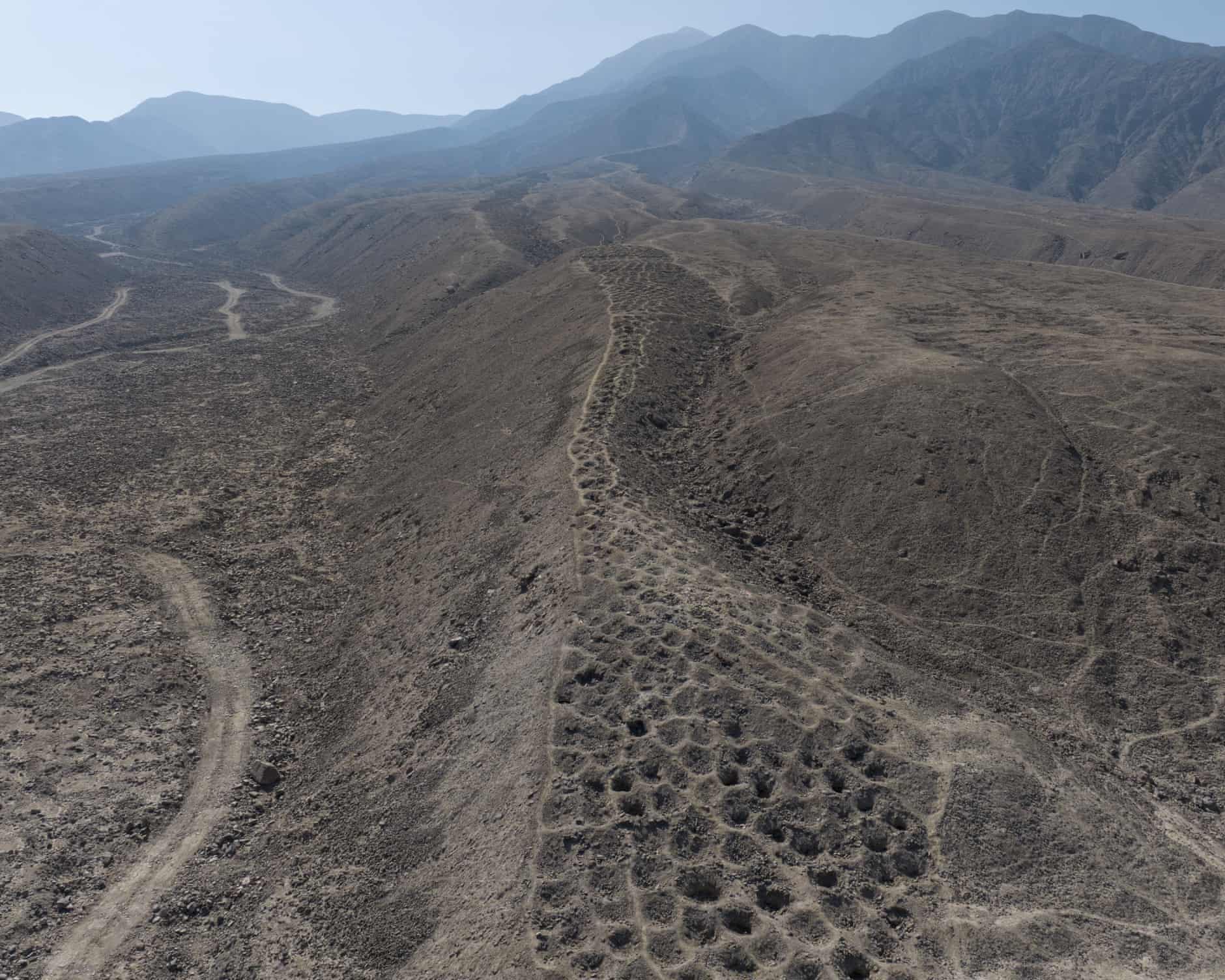
Photo: C. Stanish/University of Sydney. Band of Holes, known as Monte Sierpe in Peru, may have been an accounting and storage system.
Sometimes the mysteries on Planet Earth can be solved just by looking at the facts in a new way. Today’s article is on probing a geographical problem, but I can’t help wondering, What if we tried tackling other intransigent problems by just looking at the challenges differently?
Richard Luscombe reports at the Guardian, “A Florida archaeologist’s decades-long persistence has helped solve one of Peru’s most puzzling geographical conundrums: the origin and purpose of the so-called Band of Holes in the country’s mountainous Pisco Valley.
“Charles Stanish, professor of archaeology at the University of South Florida, and an expert on Andean culture, spent years studying the more than 5,200 curious hillside shallow pits known to local residents as Monte Sierpe — serpent mountain.
“He surmised during numerous field trips since the 1980s that the holes were man-made indentations created during the pre-Inca period for a rudimentary market place, then adapted by Incan civilization into a sophisticated kind of accounting and storage system, likely for agriculture.
“Rival theories abounded — from the sensible to the bizarre. [One] aired on the Ancient Aliens television program and exploited by an enterprising travel company was that they were crafted by extraterrestrial beings, perhaps to cover up the crash of their spacecraft.
“Now Stanish, in partnership with Dr Jacob Bongers of the University of Sydney, his former graduate student at the University of California, Los Angeles, believes he has found the smoking gun. On their most recent expedition they used advanced drone technology to conduct the first comprehensive aerial mapping of the site, producing high-resolution images revealing ‘striking patterns’ in how the holes were organized.
“The rows of holes, each between 3ft and 6.5ft wide, appeared segmented and mathematically structured, they said, a layout mirroring khipus, knotted-string devices the Inca used for counting and record keeping.
“ ‘Monte Sierpe is extremely difficult to map from the surface,’ Stanish said. ‘Even from the mountain above you can’t see its full pattern because of the permanent haze in the area. And because there were few artifacts, archaeologists couldn’t date or interpret it accurately.’
“Even more conclusive, Stanish said, were the results of microbotanical analysis of sediment samples taken from inside the holes. Fossilized seeds revealed traces of crops such as maize and wild plants traditionally used for weaving and packaging goods.
“ ‘We proved that the seeds didn’t fly in, they weren’t airborne, they had to be put there by humans,’ he said. ‘We didn’t get any, with one exception way down below, colonial-era seeds, and we got one carbon-dated to slightly pre-Inca. … And the coolest stuff was we found the reeds, the traditional reeds and the willows that the Inca and the Quechua peoples use to carry commodities, even up to the present day.’ …
“Stanish said future work will focus on further analysis of the recovered seed samples, while Bongers plans to lead an upcoming expedition for more excavation. …
“He said he hoped that authorities in Peru would recognize the historical significance of the holes, and move to protect them.
“ ‘I’m not worried about tourists, about foreigners coming,’ he said. ‘I’m worried about landowners getting the land and then irrigating it. People have to make a living. [But] this is a precious site, for the Indigenous peoples and for their pride, and it’s important to recognize that.’ “
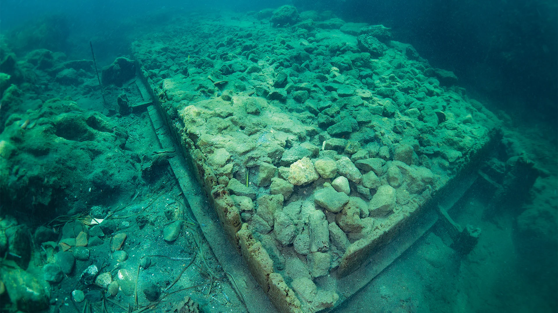
Photo: Alessandra Benini. The ruins of Aenaria were buried in the sea for nearly 2,000 years, preserved underneath volcanic sediments.
Today’s story is about finding Aenaria, a Roman port that disappeared under the sea after a volcano erupted. Eva Sandoval at the BBC begins by describing a tour you can take there if you are interested in archaeology.
“As our tour sets sail, the vast Bay of Cartaromana opens up before us. Jagged cliffs shoot up from the waves; sunbathers sprawl on the inlet bridge leading to the 2,500-year-old Aragonese Castle. … After just 10 minutes at sea, we reach a network of buoys marking the ruins below. I press my hands against the vessel’s transparent bottom. Through the turquoise-blue water, between waving fields of seagrass and small striped fish, I glimpse a pile of rocks. Then the seagrass parts and I see that the rocks are arranged into a long rectangular form, its sides encased in wooden planks. This is an ancient city’s quay; buried in the cool dark for centuries and perfectly preserved. …
“I am on the Italian island of Ischia, where sometime around AD180, the Cretaio volcano erupted, and the ensuing shockwaves sank the Roman port city of Aenaria beneath the sea.
“At least, that’s what archaeologists think happened. … There are no records of the explosion, and very little written about the settlement itself. For nearly 2,000 years, there was no physical trace of it either. …
“The first hints of its existence were in 1972, when two scuba divers found Roman-era pottery shards and two lead ingots off Ischia’s eastern shore. The find intrigued archaeologists, but the ensuing investigation, helmed by local priest Don Pietro Monti and archaeologist Giorgio Buchner, yielded nothing. … The case went cold for nearly 40 years.
“Then, in 2011, passionate local sailors reopened the excavation, this time digging into the sea floor. Soon, they were able to confirm that 2meters beneath the bay’s volcanic seabed lay the ruins of a massive Roman-era quay. …
“As far as anyone had ever known, Ischia’s DNA was Greek. The island was renowned as the site of the first Greek colony in the Italian peninsula, established around 750BC in the north of the island. …
“When the Romans seized Pithecusae sometime around 322BC, they renamed the island Aenaria – a name that appears in ancient texts from Pliny the Elder to Strabo, often in relation to military events. But unlike the Greeks, who left behind a necropolis, kilns and troves of pottery, the Romans left only a few modest tombs, engravings and scattered opus reticulatum. …
” ‘The name was documented,’ echoes local resident Giulio Lauro. ‘But no one could find the place.’ Archaeologists had been looking for Roman Ischia on dry land, but it was buried below the sea.
“Lauro is the founder of the Marina di Sant’Anna; the cultural branch of the Ischia Barche sea-tourism cooperative. Along with various affiliated cultural groups – comprised of Ischian seafarers, history enthusiasts and archaeologists – they have self-funded the excavations for the past 15 years.
“Lauro is quick to tell me that he’s no scientist. ‘But I love the sea,’ he said. ‘In 2010, I got the idea to look again.’ …
“There were challenges, recalls Lauro: ‘Getting authorizations, training people, sourcing funds. We started from zero. We were lucky to believe in it. And then to actually find it.’ …
” ‘It was believed that the Romans never built a city on Ischia,’ says [Dr Alessandra Benini, the project’s lead archaeologist]. ‘It was the opposite.’ …
“Each summer, Benini and her team excavate the sea floor. Progress is painstaking due to a perennial shortage of funds. … During the site’s active months, curious visitors can take glass-bottomed boat tours, as well as snorkelling and scuba excursions to get even closer to the ruins. ‘You can see the underwater archaeologists at work, the equipment they use and everything involved,’ says Benini. …
“I ask Benini what she hopes to find this summer.
” ‘My dream is to find the foundations of the residential city,’ she says. ‘If we’ve found the port, then we know there was a city.’
“The team hopes to introduce Lidar, Georadar and sub-bottom profiler instruments into the digs, but Benini points out, ‘That’s expensive. We need more investors.’ “
Photo: Jesse Casana. Jonathan Alperstein, a researcher, excavates land on an unexpectedly large ancient agricultural site in Michigan.
The other day, my neighbor surprised me with a bunch of aerial photos of my New Shoreham place that were taken by her nephew’s drone. As drones are used more and more in warfare, I sure like thinking about the harmless and often useful things drones do.
In today’s example, a mystery revealed by drone led to a long-term collaboration between Menominee tribal members and non-Indigenous archaeologists in Michigan.
Nell Greenfieldboyce reports at National Public Radio (NPR), “Archeologists studying a forested area in northern Michigan say they’ve uncovered what is likely the largest intact remains of an ancient Native American agricultural site in the eastern half of the United States.
“The researchers used a drone equipped with a laser instrument to fly over more than 300 acres, taking advantage of a brief period of time after the winter snow had melted away but before the trees had put out their leaves.
“This allowed the drone to precisely map subtle features on the surface of the exposed ground, revealing parallel rows of earthen mounds. This is what’s left of raised gardening beds that were used to grow crops like corn, beans, and squash by the ancestors of the Menominee Indian Tribe of Wisconsin, in the centuries before European colonizers arrived.
“The mounds appeared to continue on beyond the surveyed area, the researchers say, showing agriculture at a surprisingly vast scale in a place that wasn’t a major population center.
” ‘We haven’t even been able to locate any significant settlement sites in this region. There’s a couple of tiny little villages,’ says Jesse Casana, a professor of anthropology at Dartmouth College and one of the authors of a new report in Science. ‘So it’s really shocking in this case to see this level of investment in an agricultural system that would require really enormous amounts of human labor to make happen.’
“It’s especially odd given the relatively poor growing conditions that far north, especially during a period of colder temperatures known as the Little Ice Age, as well as the presence of wild rice right nearby, says Madeleine McLeester, a Dartmouth anthropologist who led the research team. …
” ‘This astonishing paper shows how much we’ve underestimated the geographic range, productivity, and sustainability of intensive Indigenous agriculture across North America,’ says Gayle Fritz, an anthropologist with Washington University in St. Louis.
” ‘The study is outstanding in many ways, one being the long-term collaboration between Menominee tribal members and non-Indigenous archaeologists,’ she says — with the other being the combination of new technologies plus ‘old-fashioned, ground-based excavation and survey.’
“While some people may envision historical Native Americans as mostly hunter-gatherers or nomads, ‘that is very incorrect,’ says Casana. ‘By the time colonists arrived, what they were encountering were a lot of pretty sedentary communities all over North America who were practicing various forms of farming,’ he says. …
“The site mapped in this new study is part of Anaem Omot, which means the ‘Dog’s Belly’ in Menominee. It’s an area along the Menominee River on the border between Michigan and Wisconsin, and is of great cultural and historical significance to the Menominee tribe.
“The region contains burial mounds and dance rings. It’s also known to have agricultural ridges, ranging from 4 to 12 inches in height, because previous work back in the 1990’s had mapped some of them.
” ‘These features are really difficult to see on the ground, even when you’re walking around, and they’re difficult to map,’ says McLeester.
“That difficulty, plus concerns about proposed mining activities in the area, is why the research team — which included the tribe’s historic preservation director, David Grignon — wanted to see if new technology could reveal more acres covered with the earthen agricultural rows.
“McLeester says they thought they’d find some more rows, but also expected that others would have eroded away since the last mapping effort. …
“But the drone surveys revealed that the field system was ten times bigger than what had been previously seen. ‘Just the scale, I would say, was unexpected,’ she says. …
“Says Casana, ‘One of the interesting things about this study is that it kind of shows us a preserved window of what was probably a much more extensive agricultural landscape.’ …
“Susan Kooiman of Southern Illinois University, an expert on the precontact Indigenous peoples of Eastern North America, says … ‘To find intact, ancient indigenous agricultural fields in any state, at any level, is very rare. …
” ‘The amount of work, and just how far these fields extend, is beyond anything that I think people suspected was going on this far north in eastern North America,’ she says. … ‘The question now is, what are they doing with all this stuff they were growing?’ “
More at NPR, here. (NPR is struggling since the massive federal cut. Help them out here if you can. No amount too small.)
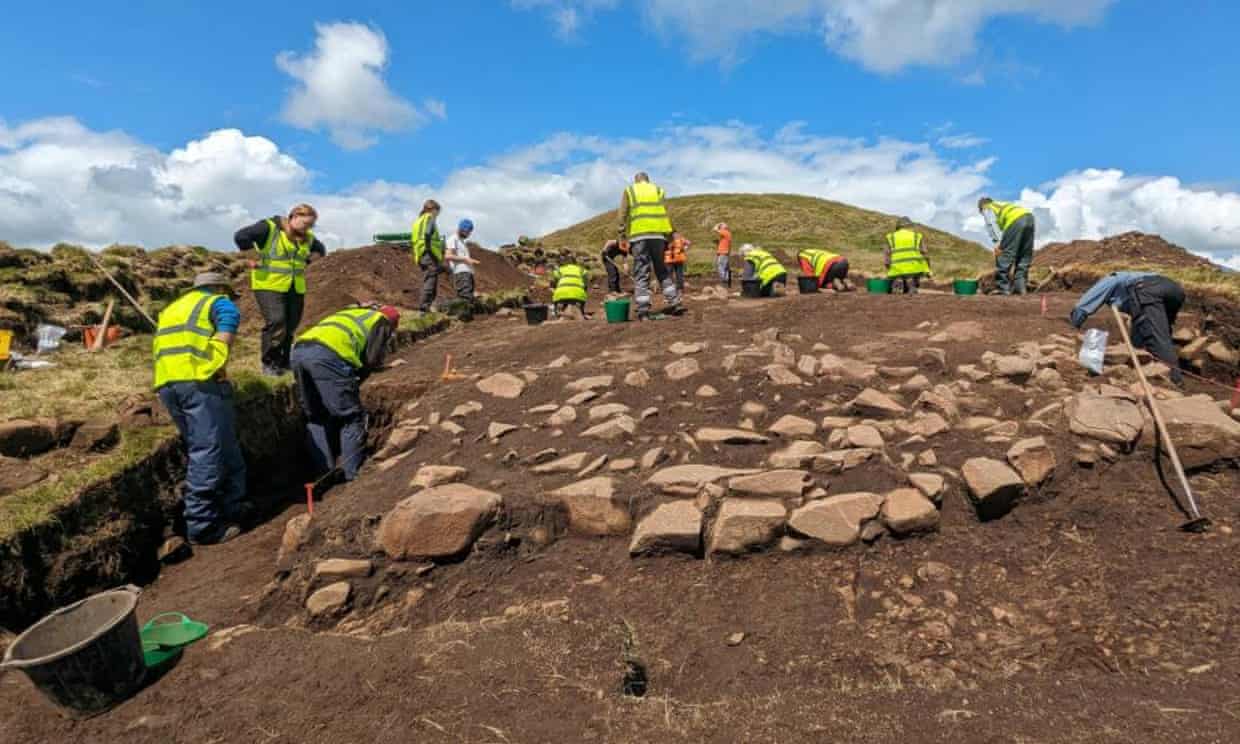
Photo: Gordon Noble, University of Aberdeen. The community archaeological dig at the East Lomond hillfort site.
Did you ever want to be an archaeologist? I think there was a period in childhood that it interested me, encouraged by gifts of picture books about the discovery of Knossos in Crete. But then I moved off in other directions.
Perhaps you had that experience, too, always wondering what it would have been like. Today there are opportunities to get a taste of that world as a volunteer.
Libby Brooks writes at the Guardian about the thrill of being a citizen archaeologist in Scotland.
“They were moving forward in a line across the 10 sq metre [~108 square foot] trench, volunteer excavators elbow to elbow with academics, and Joe Fitzpatrick was at the far edge.
“He was digging around the hearth of a building, about 60cm (2ft) below surface level, when he hit the earth twice with his mattock and out it popped – a rare bronze spear butt, a metal fitting placed over the end of a wooden shaft to counterbalance the spear head. Covered in Pictish inscriptions, it had remained buried for more than one and a half millennia, and was one of the most groundbreaking archaeological discoveries of 2024 in Scotland.
‘The hair stands up on the back of your neck and you tingle,’ says Fitzpatrick, of the moment he realized the significance of the find. ‘It is special.’
“Fitzpatrick, who has always had a passion for history, got involved with the regular community dig at the site of the East Lomond hillfort, beside the village of Falkland in Fife, as a retirement activity.
“He was working next to Prof Gordon Noble, the head of archaeology at the University of Aberdeen, who was leading the dig: ‘We just looked at each other,’ Fitzpatrick recalls. ‘Two men with their jaws hanging open, dumbfounded.’
“He helped unearth the artifact in July, during excavations organized by the Falkland Stewardship Trust and the University of Aberdeen, which bring together members of the public and students to help uncover settlement remains dating from around the second or third century AD to around AD700.
“He is one of a growing legion of citizen archaeologists, eager volunteers who are sustaining projects across the country even as volunteering more generally is in decline.
“Fitzpatrick says: ‘A lot of people who retire are more aware of keeping active and outdoors, but we also have young people working out what to do after their studies, and the media has broadened archaeology’s appeal with programs like ‘Time Team’ and ‘Digging for Britain’ – it’s not just Oxford dons doing it.’
“An ‘exceptionally rare’ find like the spear butt boosts team morale … says Noble. ‘Community involvement has really ramped up in the past 10 years,’ he says. ‘There’s the excitement of uncovering the past on your doorstep. These volunteers come from all walks of life.’ …
“Although Volunteer Scotland has warned that last year’s Scottish Household Survey results ‘point to a crisis in volunteering,’ for those participating in culture and heritage the numbers remain constant, compared with a drop of four percentage points elsewhere.
“Jeff Sanders, the head of outreach for the Society of Antiquaries of Scotland, says the cost of living crisis has affected individuals and their ability to participate, but also organizations and their capacity to put things on for volunteers. …
“As well as funding challenges, Sanders says there is a push to diversify volunteering – volunteers are often retirees with more disposable income. Sanders also works on the Make Your Mark campaign, which worked with the Scottish Refugee Council over the summer to co-design archaeology taster sessions to attract people who wouldn’t ordinarily get involved in volunteering.
“This ‘continuing upward trend’ in community involvement has prompted Emily Johnston to chart the citizen archaeologist phenomenon as part of her doctoral research at the University of Edinburgh. She has launched a database of community archaeology activities across Scotland, Outreach in Scottish Archaeology (OScA). …
“Says Johnston, ‘A lot of volunteers have been really interested in archaeology from a young age. It’s about creating a tie to your past and gives people a sense of identity.’ “
I love the idea of “taster sessions” for volunteers — in any field. I imagine more people would take on gigs if they knew there was no embarrassment about dropping out. They would keep trying things until they found the right opportunity for them. I tried volunteering with many ESL [English as a Second Language] organizations until I found the right fit.
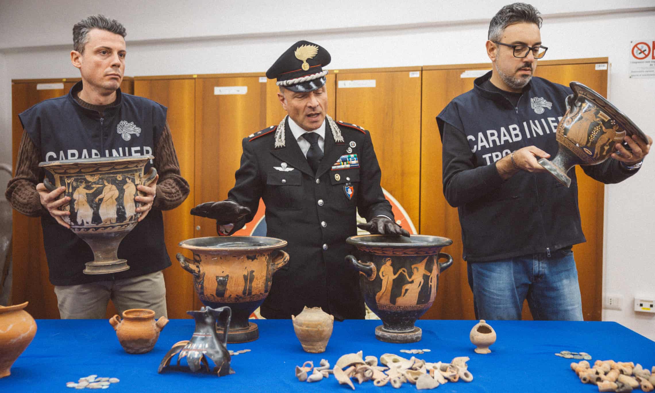
Photo: Roberto Salomone/The Guardian. Italy’s Carabinieri cultural heritage protection squad at work. The force recently uncovered a clandestine dig in the middle of Naples.
Every morning on the social network Mastodon, German archaeologist Nina Willburger (@ninawillburger) posts a beautiful, or at least curious, artifact from a dig. The history of archaeology suggests that not all of them were unearthed in legal ways, but they are in museums.
Nowadays there are strict laws around digging. Which is why Italy needs its cultural heritage protection squad.
At the Guardian, Angela Giuffrida wrote about the team’s latest success.
“Looking towards the semicircular apse with a frescoed image of a partially identifiable Christ on a throne staring back at them, the archaeologists crouching in the small space deep beneath a residential building in Naples were left speechless. They were amid the remains of an 11th-century church.
“The archaeologists, however, could not take the credit: the historic jewel, which had just been seized by police, was dug up by tombaroli, or tomb-raiders, illicit gangs who for decades have been plundering Italian cultural sites, in turn fueling the global market for stolen art and antiquities.
“Investigators believe the group’s leader was a local entrepreneur, currently under investigation, who owns two apartments in the building above. His cellar was turned into a well-organized excavation site, from where the tomb-raiders dug a warren of tunnels leading them about 8 metres [~26 feet] down into ancient Naples, where they unearthed medieval art. …
“But impressive though their workmanship was – they even installed concrete pillars to prevent the structure from collapsing – officers from the Naples unit of Italy’s Carabinieri cultural heritage protection squad unmasked the gang and confiscated the church after a covert investigation.
“The force also recovered 10,000 fragments of Roman and medieval pottery from the alleged gangmasters’ homes and 453 intact artifacts, including vases, terracotta lamps and coins. …
“The gangs commonly work by marking out clandestine excavation spots close to known archaeological sites, which in the Campania region surrounding Naples can include Pompeii, Herculaneum, Paestum or areas where there were Roman settlements. So uncovering a clandestine dig in the middle of the city took the specialist squad by surprise.
“ ‘When you think of Pompeii, for example, you know a dig can lead to a wealthy domus where prestigious objects can be found,’ says Massimo Esposito, the chief of the squad’s unit in Naples. ‘But it’s rare to find one in the heart of Naples.’
“The group’s alleged leader is believed to have had an inkling that there might be something beneath his home when construction works nearby on the city’s metro were interrupted and the site cordoned off after a small part of the remains of another, albeit less historically interesting, church emerged.
“The group worked for several months, carrying out their noisiest activity during the day, but not loud enough to attract complaints from the building’s residents. Little did the gang know that their comings and goings were being observed by Esposito’s team, with the squad staking out the building and wiretapping its alleged leader’s phone. Suspicions were especially aroused after seeing him carrying boxes filled with materials. …
“The Carabinieri’s cultural heritage protection squad was established in 1969 with the task of protecting Italy’s priceless cultural assets. Since then, more than 3m stolen artworks and relics have been retrieved, including those that ended up on display in some of the world’s biggest museums, such as the Getty in Los Angeles.
“Art and relics thieves in Campania especially thrived in the 1980s, taking advantage of a devastating earthquake at the beginning of that decade to ransack churches of paintings. The long-lost La Desposizione, a 2-metre high masterpiece painted by Angelo Solimena in 1664 depicting the crucifixion, was recently returned to Campania only after it was spotted on display in a museum in the Marche region. …
“Esposito met the Guardian in his unit’s office located in Castel Sant’Elmo, a medieval fortress overlooking Naples. He was surrounded by relics … including a wine amphora and a house-shaped sarcophagus believed to have contained the remains of a child, and various other funerary objects dating back to the fourth century AD. The artifacts are usually kept there pending the conclusion of judicial cases, before being either returned to their origin or entrusted to museums. …
“Data in recent years indicates a gradual decrease in crimes against cultural heritage. Laws for crimes against cultural heritage have been tightened, and work intensified to return stolen assets from abroad. … Use of social media, especially over the past decade, has also made it easier for the squad to identify thieves. A trove of funerary treasures, believed to have belonged to Etruscan princesses and illegally excavated from an underground tomb in Umbria, was retrieved in November after police came across a photo of the bungling thieves posing on Facebook as they attempted to sell it online.
“ ‘Despite the risk, there is sometimes this egotistical element: they want to boast about the beautiful items they’ve found,’ says Esposito.”
Check out the treasures at the Guardian, here. No paywall. Donations are important to the Guardian‘s journalism.
Photo: North Carolina office of state archaeology. A rice gate, seen here in 1986. At Eagles Island, North Carolina, in the late 1700s, the enslaved Gullah Geechee people began creating ingenious rice fields.
If the people described in this archaeological report used brilliant rice-growing techniques while enslaved, imagine what they might have done if they had been free! But, alas, slavery destroys lives of the enslaved and their descendants for generations, as Pat Conroy documented in The Water is Wide, his memoir about teaching.
In an in-depth article at the Guardian, Adria R Walker writes about recent archaeological discoveries concerning the Gullah Geechee people of the American South.
“As a former deputy state underwater archaeologist, Mark Wilde-Ramsing can’t help but look down. While rowing around North Carolina’s Eagles Island, at the tip of the Gullah Geechee corridor, he noticed signs of human-made structures, visible at low tide. Though he’d retired, he was still active in the field and knew his former agency hadn’t recorded the structures – which meant he had come across something previously undocumented. …
“Wilde-Ramsing knew the area had once been full of rice fields. His neighbor, Joni ‘Osku’ Backstrom, was an assistant professor in the department of environmental sciences at the University of North Carolina-Wilmington whose specialty was shallow-water sonar, and he had the skills and technology to explore the area. Using a sonar device, the duo detected 45 wooden structures in the river, and the remote sensing tool allowed Backstrom and Wilde-Ramsing to acoustically map the canal beds. …
“Spanning 2,000 acres (809 hectares) of the northern end of Eagles Island, the 45 irrigation devices were developed by enslaved people, who would later come to be known as the Gullah Geechee. The devices were used to control water flow for the rice fields in conjunction with earthen dams and levees, Wilde-Ramsing said.
Their existence provides further evidence of the engineering and technological skills that Gullah Geechee people used for rice cultivation, beginning in the late 1700s at the latest.
“Backstrom and Wilde-Ramsing documented their findings in a study published earlier [in 2024]. ‘The use of the island for this endeavor prior to the Civil War, in large part rested on the shoulders of transplanted and enslaved Africans and their descendant Gullah Geechee tradition,’ the study reads.
“The team’s discoveries, which came after two years of research in and around Eagles Island, have helped further shed light on the ingenious, skilled work of the Gullah Geechee people. Though Gullah Geechee people have been studied for centuries, Backstrom and Wilde-Ramsing’s research is the first to focus on their irrigation systems. The research couldn’t come soon enough: Eagles Island is environmentally vulnerable, both because of climate change and ongoing development. The duo registered their sites with the state, making development more difficult as a means to ensure the protection of cultural artifacts.
“ ‘The whole area was originally swamp. It was cleared mostly in the post-colonial, early 1800s period for tidal rice cultivation because that area was freshwater,’ Wilde-Ramsing said. ‘They were able to actually use, regulate, introduce the water and drain it with the tides.’ …
“The work the Gullah Geechee people did would have been exhaustive. Wilde-Ramsing says it required removing the cypress forests, then building dams and levees. Growing rice necessitated the use of water, so they created long wooden boxes, or ‘trunks,’ with gates on either side, that allowed them to let the water in by opening the gates. …
“The enslaved populations throughout the Gullah Geechee corridor – which spans the coasts of North Carolina to upper Florida – were isolated in such a way that they developed and maintained a culture different from that of most plantations.
“ ‘[They were] from coastal regions of west Africa, an area that had similar environs to those along the southern Atlantic seaboard centering on Georgia and the Carolinas, where rice agriculture was a mainstay of the economy,’ the study reads. …
” ‘I didn’t quite realize the role that rice played. It rivaled cotton during the 1840s and 50s,’ Backstrom said. ‘It was all over Europe and the US and it was all run by African Americans. A lot of it was developed based on their skills. I’m just happy that it’s coming to light and they’re getting their – I won’t say new – but recognition that this was an amazing thing, amazing work.’
“Even though Wilde-Ramsing and Backstrom’s discovery likely won’t permanently stop either development or climate change, not least because the island is owned by multiple private entities, the existence of historic, cultural artifacts can ensure that the Gullah Geechee structures are at least documented instead of simply being razed and forgotten.
“The researchers have been in communication with East Carolina University’s maritime program, and the school plans to send a contingent to the site to study some of the characteristic types. People from the school will be able to work on noting the various structures, trying to figure out how they operated and taking samples. Backstrom said that they’ve also been in contact with researchers at George Mason University in Fairfax county, Virginia, including a professor who had ancestors [from the area].
“In terms of further discovery, a mix of approaches best suits the complicated terrain. ‘We’re thinking about using drone imagery,’ Backstrom said. ‘We have some preliminary drone footage, which gives us access to these areas at dead low tide, areas that we had a lot of difficulty with, even with a very small vessel.’ The area is remote, full of tight nooks and crannies. It’s ‘particularly challenging because of the tides and the timing,’ he said. The different combinations of drone imagery and sonar mean the researchers aren’t limited by turbidity in the water.
“Backstrom hopes to go to west Africa, specifically to Senegal or the Senegambia region, where many Gullah Geechee people were from, to learn about the history of rice farming, including the roles women and children played. Children, for instance, tasted the water to ensure too much saltwater wasn’t being let in, and women helped in the actual cultivation of the rice, using skills from their home countries that were passed down throughout generations.”
More at the Guardian, here. No firewall. Donations help save reliable news.
Photo: Mark Viales/Al Jazeera. Luis May Ku, 49, poses with his hands painted in Maya blue outside his home in Dzan, Yucatan, Mexico, on September 9, 2024.
Today’s article is about how the preparation of an ancient paint color was lost to history — and about how a contemporary Mayan’s persistence brought it back.
Mark Viales has the story at Al Jazeera.
“Surrounded by dense jungle and beneath intertwining canopies of towering trees, Luis May Ku, 49, trudges ahead through shoulder-height bushes searching for a rare plant. The oppressive 40-degree Celsius (104 Fahrenheit) heat dulls the senses, and the air, thick with humidity, clings to our skin, causing beads of sweat to form and trickle down.
“After scouring the thickets, May, an Indigenous Maya ceramicist, stumbles upon a shrub similar in shape and texture to others around him, but insists this one is special. He touches the soft, sprawling leaves and tells me it is wild ch’oj (‘indigo plant’ in Mayan, anil in Spanish) – or Indigofera suffruticosa – which is a key ingredient to create the revered Maya blue pigment.
“ ‘It took years before I found it – indigo – and most people from Yucatan believed it to be extinct on the peninsula,’ May says with a pensive look, lifting his sombrero made from interwoven huano palm leaves to wipe his brow with the back of his hand. …
“ ‘The Yucatan Peninsula is going through its worst drought in decades,’ he says. ‘Let’s rest, and I’ll tell you how I recreated Maya blue.’ …
“The bright azure color can still be seen among the ruins at the world-famous archaeological site of Chichen Itza in Yucatan on murals more than 800 years old.
“Only a handful of blue pigments, such as lapis lazuli or Egyptian blue, were created by ancient civilizations. Still, these were predominantly dyes or minerals, while Maya blue required a chemical combination of organic and inorganic substances. Before synthetic versions of blue pigment arrived during the Industrial Revolution, the color was exceedingly rare and often more expensive than gold in Europe. The semiprecious lapis lazuli stone originated in the mountains of Afghanistan and was only accessible to the wealthy. Yet, in the New World, blue pigment was plentiful and thrived.
“When the Spanish arrived in the 15th century, they exploited Maya blue, along with all the treasures they stole from Mesoamerican civilizations. The Spanish controlled the prized colorant until the late 17th to early 18th centuries when synthetic substitutes began to arrive. Common knowledge of Maya blue then disappeared until its rediscovery in the 20th century.
“In 1931, American archaeologist H.E. Merwin first found ‘a new pigment’ on murals within the Temple of The Warriors at Chichen Itza. It was given the name ‘Maya blue’ a few years later (1942) by American archaeologists R.J. Gettens and G.L. Stout. Research paused during World War II, and it was not until the 1950s that powder diffraction analysis revealed the Maya blue pigment had been made by mixing clay, palygorskite (a rare fibrous clay) and indigo. In 1993, Mexican historian and chemist Constantino Reyes-Valerio published a recipe to recreate the color using palygorskite, montmorillonite (a soft clay) and indigo leaves.
“Modern-day scientists value the mysterious paint because its unique resilience to the elements has kept it in near-perfect condition on pre-Columbian murals, artifacts and codices, even a millennium later. …
“It took scientists a long time to understand the formula, and studies are continuing. …
“May was born in Dzan, a village of 6,000 people in the western part of Yucatan about 100 kilometres (62 miles) south of the state capital city, Merida. Most of the peninsula is flat and pocketed with cenotes formed in the aftermath of the cataclysmic meteor that wiped out the dinosaurs. Yet in the municipality of Ticul, which includes Dzan, the land rises somewhat, giving way to the Puuc (‘hills’ in Maya) region, which has been inhabited since around the 7th century BC.
“Several important pre-Columbian Maya cities dot the area, such as the World Heritage Site of Uxmal, an ancient Mayan city with beautiful Puuc-style architecture. The buildings in the ruins have smooth, vertical walls with features such as columns, elaborate friezes, decorated masks and curved snakes, mostly representing the rain god, Chaak, and the feathered serpent deity, Kukulkan, respectively.
“The region remains famous today because of its high-quality pottery and clay sculptures, especially the town of Ticul, nicknamed ‘The Pearl of the South’ [3.1 miles] from Dzan. The area is also a source of palygorskite – found in caves – which some potters use to grind and mix with other clays to make pottery more durable. Here, May cut his teeth in ceramics as a student among some of the most renowned artisans in Mexico and eventually began his journey to recreate Maya blue.
“ ‘I dreamt of working as my ancestors did with clay and natural pigments,’ he says, tapping a finger on his temple. He reminds me that, like most people in his village, his mother tongue is Maya, and emphasizes that he is proud to work like his forefathers in creating Maya blue.
“May was 17 years old when he started sculpting wood while studying Maya Culture at the Autonomous University of Yucatan, taking inspiration from Maya architecture around his region. One of his passions was capturing faces with distinct Maya features. About 20 years later, he followed in the footsteps of ceramicists from Ticul and began sculpting with clay and learned from other ceramicists about adorning pottery with organic pigments such as red and white.
“However, he was also fascinated to learn that they also used synthetic pigments – like blue. On a visit to the Maya ruins in Bonampak, Chiapas, he was captivated by murals painted with a beautiful turquoise colour. May discovered that the sky-blue pigment was held sacred by his ancestors and used during rituals. After questioning his colleagues further, he learned that the knowledge needed to create this color in its traditional form had been lost in Yucatan, leading him towards a path of rediscovery of ancient techniques. …
“On January 9, 2023, May announced on social media that researchers in Italy and Mexico had validated his formula. It was the first time the world had seen Maya blue made with traditional methods in Yucatan for almost two centuries.
“David Buti, a researcher at the Institute of Heritage Science of the National Research Council in Perugia, Italy, and Rodolfo Palomino Merino, a professor of physics and mathematics at the Autonomous University of Puebla, Mexico, sent him PDFs with scientific breakdowns of their analyses. Merino’s work came through first in August 2022, with a 95 percent probability that May’s formula was genuine. In 2023, Buti’s analysis verified that it was 100 percent Maya blue. Both academic institutions confirmed that his samples, which contained palygorskite, calcium carbonate and indigo, caused an ‘intercalation between the indigo molecules’ – a chemical reaction – resulting in an authentic Maya blue.
“ ‘I was ecstatic,’ May says. ‘My ancestors used Maya blue exclusively in ceremonial practices, and even then, it was in limited supply. It was the color of the gods, and only the elite were permitted to use it.’
“ ‘As a child, my father and grandfather taught me that consistent hard work pays off. Never giving up and trying your best, even if you do not succeed, are typical Mayan values.’ “
For Valentine’s Day this year I thought I would post about the love people have for pets. The article I found at Yale University’s human relations website is a little research-y, but it shows just how far back in history humans have felt that kind of love.
“The human love of pets is a powerful and global phenomenon. For many pet owners, their furry (or scaly) domestic companions transcend any simple categorization of non-human animal. Indeed, research shows that it is a growing global trend for pet owners to consider their animals to be full members of their families; to dote upon them as they would children or romantic partners, both emotionally and financially; and to thereby develop strong bonds of dependency, love, and support.
“Gray and Young (2011) conducted a broad cross-cultural study of human–pet dynamics around the world utilizing … a stratified random sample of 60 culturally, linguistically, and geographically diverse societies represented in eHRAF [Human Relations Area Files] World Cultures. Their study revealed that ‘dogs, birds, and cats were the most common pets, followed by horses, other hoofed mammals such as water buffalo, rodents, nonhuman primates, and pigs.’ … Attitudes and sentiments towards the domesticated animals vary, with many societies attaching spiritual meaning to their birds, cats, or dogs. …
“The emotional connection between pets and their owners is worthy of cross-cultural attention. For example, it has been discovered that dogs are able to read emotional cues from the faces of their owners and to respond accordingly. Other recent studies have shown that people tend to have more compassion for animals who are suffering than for adult humans in similar circumstances, treating the hurt dogs akin to helpless infants who need protection. Based on global data, researchers in this telling social experiment concluded that, by and large, subjects ‘did not view their dogs as animals, but rather as “fur babies” or family members alongside human children.’
“As to the origins of human-pet relationships, anthropologists suggest that our propensity for keeping pets, as well as our finely honed empathy for their emotional state, stems from the process of animal domestication in early human history, beginning with dogs and continuing to horses, sheep, goats, and others:
” ‘In each case, humans had to learn to put themselves in the minds of these creatures in order to get them to do our bidding. In this way our senses of empathy and understanding, both with animals and with members of own species, were enhanced. Our special relationship with animals is revealed today through our desire to have pets (McKie 2011).’ …
“Evidence of ancient burials from eHRAF Archaeology supports recognition of a longstanding bond between humans and animals far back into prehistory. For example, in ancient Egypt (5000-2000 BCE), Rice finds that, ‘amongst the graves at Helwan are examples of the burials of dogs and donkeys; as these do not seem to be the subject of cult or religious observance, it may be that they were family pets, since the Egyptians always kept animals about them, as members of their households’ (1990: 131). Similarly, on the other side of the world, the purposeful interment of animals in prehistoric settlements is known throughout the American Southwest and northern Mexico. According to Woosley and McIntyre, at the Wind Mountain site in New Mexico dating back to 2000-600 BP, the animals buried included dogs, bears, turkey, golden eagles, hawks, mourning doves, and scarlet macaws (1996: 281).
“Edmund Leach’s seminal work, Animal Categories and Verbal Abuse (1964), presents the human relationship to animals in terms of social distance. Attitudes towards different animals reflect our familiarity with them, so that the most familiar or ‘closest’ to ourselves are subject to ritual provisions or prohibitions because they are considered ‘taboo.’ They are also most worthy of human-like care and devotion. This is why people generally avoid eating the animals that they might also keep in their homes as pets. …
“The dynamic of intimacy in the human relationship to animals recurs in the ethnographic literature. The closeness of human-animal relationships is evident around the world with instances of beloved species being cared for as fondly and tenderly as human babies.”
Check out more at Yale’s Human Relations Area Files, here. No paywall.
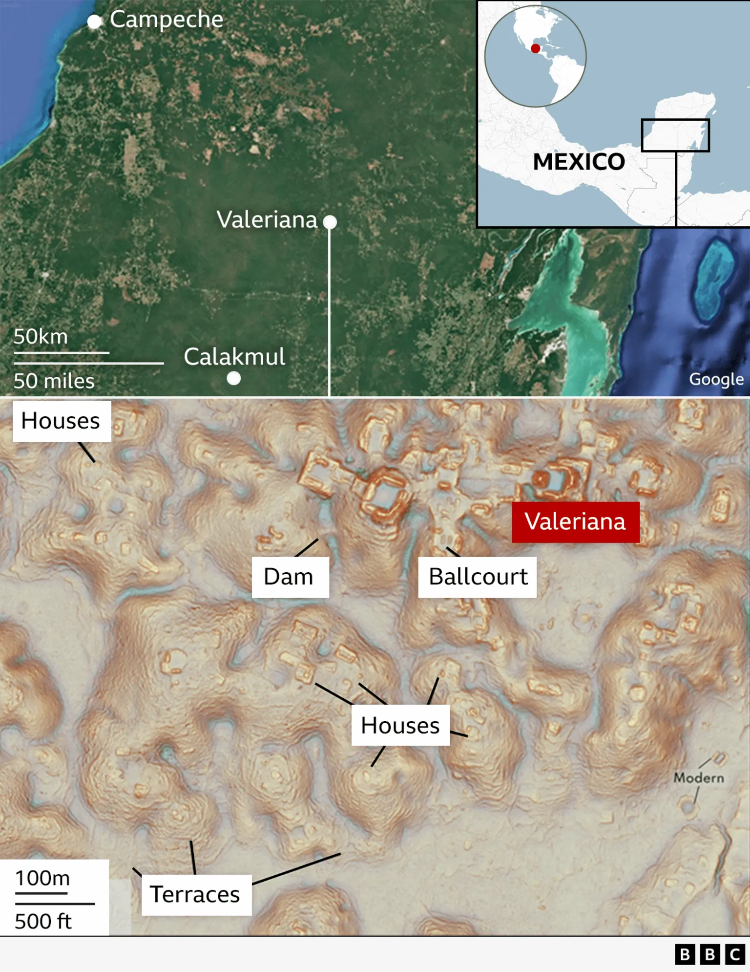
Photo: BBC. A PhD student found a lost city by accident in eastern Mexico, in Campeche.
Talk about happy accidents! I’m sure we have all experienced a few, whether in cooking or driving around. And we often hear of happy accidents in science. Today, we learn about an alert PHD student who found an ancient civilization without precisely looking for one.
Georgina Rannard writes at the BBC, ” ‘I was on something like page 16 of Google search and found a laser survey done by a Mexican organization for environmental monitoring,’ explains Luke Auld-Thomas, a PhD student at Tulane university in the US.
“It was a Lidar survey, a remote sensing technique which fires thousands of laser pulses from a plane and maps objects below using the time the signal takes to return.
“But when Mr Auld-Thomas processed the data with methods used by archaeologists, he saw what others had missed — a huge ancient city which may have been home to 30,000-50,000 people at its peak from 750 to 850 AD. … Mr Auld-Thomas and his colleagues named the city Valeriana after a nearby lagoon.
“The find helps change an idea in Western thinking that the Tropics was where ‘civilizations went to die,’ says Professor Marcello Canuto, a co-author in the research. Instead, this part of the world was home to rich and complex cultures, he explains. …
“It is ‘hidden in plain sight,’ the archaeologists say, as it is just 15 minutes hike from a major road near Xpujil, where mostly Maya people now live.
“There are no known pictures of the lost city because ‘no one has ever been there,’ the researchers say, although local people may have suspected there were ruins under the mounds of earth.
“The city [had] two major centers with large buildings around 2km (1.2 miles) apart, linked by dense houses and causeways. It has two plazas with temple pyramids, where Maya people would have worshipped, hidden treasures like jade masks and buried their dead. It also had a court where people would have played an ancient ball game. There was also evidence of a reservoir, indicating that people used the landscape to support a large population. …
“Professor Elizabeth Graham from University College London, who was not involved in the research, says it supports claims that Maya lived in complex cities or towns, not in isolated villages. …
“The research suggests that when Maya civilizations collapsed from 800 AD onwards, it was partly because they were so densely populated and could not survive climate problems.
” ‘It’s suggesting that the landscape was just completely full of people at the onset of drought conditions and it didn’t have a lot of flexibility left. And so maybe the entire system basically unravelled as people moved farther away,’ says Mr Auld-Thomas.
“Warfare and the conquest of the region by Spanish invaders in the 16th century also contributed to eradication of Maya city states.
“Lidar technology has revolutionized how archaeologists survey areas covered in vegetation, like the Tropics, opening up a world of lost civilizations, explains Prof Canuto. …
” ‘I’ve got to go to Valeriana at some point. It’s so close to the road, how could you not? But I can’t say we will do a project there,’ says Mr Auld-Thomas. ‘One of the downsides of discovering lots of new Maya cities in the era of Lidar is that there are more of them than we can ever hope to study,’ he adds.
More at the BBC, here. Seems to me the discovery was hardly an accident. Anyone with the patience to look at page 16 of a Google search deserves a bit more credit.
Photo: Michael Frachetti. Using a drone equipped with LiDAR (light detection and ranging equipment), archaeologists have mapped two abandoned cities in the mountains of Uzbekistan. The location of the larger city, known as Tugunbulak, is pictured above.
Over the years, I’ve read quite a few novels from other lands and cultures, including one unsettling story about nomads in Africa and another called The Railway, by Uzbek writer Hamid Ismailov. Possibly something died in translation, because I remember little of either book. Wikipedia reminds me that The Railway is about a small town on the Silk Road as seen through the eyes of its inhabitants.
Although the books did not come across as great literature, the cultures continue to draw one who hears so little about them from the American media unless it’s radio show The World. The Monitor andReuters also seek out such stories.
Will Dunham of Reuters reports, “In the mountains of Uzbekistan, archaeologists aided by laser-based remote-sensing technology have identified two lost cities that thrived along the fabled Silk Road trade route from the 6th to 11th centuries AD — the bigger one a center for the metal industry and the other reflecting early Islamic influence.
“The fortified highland cities, located three miles apart at around 6,560-7,220 feet above sea level, are among the largest known from the mountainous sections of the Silk Road, the sprawling web of overland trade routes linking Europe and the Middle East to East Asia.
” ‘These cities were completely unknown. We are now working through historical sources to find possible undiscovered places that match our findings,’ said archaeologist Michael Frachetti of Washington University in Saint Louis, lead author of the study published in the journal Nature.
“The bigger of the two, called Tugunbulak, covered about 300 acres, with a population perhaps in the tens of thousands, the researchers said. It was one of the largest cities of its time in its region of Central Asia, rivaling even the famed trade hub Samarkand situated about 70 miles away. It existed from around 550 to 1000 AD. …
“The other city, Tashbulak, was only a tenth the size of its neighbor, with a population perhaps in the thousands, the researchers said, lasting from around 730-750 to 1030-1050 AD.
“Founded in early medieval times in what is now southeastern Uzbekistan, the cities were eventually abandoned and forgotten until archaeologists came across the first evidence of them while scouring a rugged mountain area, with deep ravines, steep ridge lines and forests. They deployed drone-based lidar remote scanning to map the scale and layout of the sites. …
“It revealed evidence of numerous structures, plazas, fortifications, roads, habitations and other urban features.
“Preliminary excavation at one of Tugunbulak’s fortified buildings — girded by thick earthen walls — yielded the remains of kilns and furnaces, indicating it was a factory where metalsmiths may have turned rich local deposits of iron ore into steel.
“The researchers are working to confirm steel was made there by chemically analyzing slag — a byproduct of iron and steel production — found at the site. The region in the 9th and 10th centuries was known for steel production. …
” ‘Tugunbulak in particular complicates much of the historical understanding of the early medieval political economy of the Silk Routes, placing both political power and industrial production far outside the regional “breadbaskets” such as Samarkand,’ Frachetti said.
“Tashbulak lacked the industrial scale of Tugunbulak but boasted an interesting cultural feature — a large cemetery that reflects the early spread of Islam in the region. Its 400 graves — for men, women and children — include some of the oldest Muslim burials documented in the region.
” ‘The cemetery is mismatched to the small size of the town. There’s definitely something ideologically oriented around Tashbulak that has people being buried there,’ Frachetti said.
“Islam arose on the Arabian Peninsula in the 7th century and rapidly spread in the successive centuries. The Silk Road enabled economic, cultural, religious and political exchanges between East and West, as the caravans that traversed its pathways toted not only a panoply of products but also people and ideas. It linked cosmopolitan Chinese cities such as Xi’an to destinations including the Byzantine capital Constantinople and the sophisticated Islamic metropolis Baghdad. More at Reuters, here.
I must say, this research sounds like fun to me. You discover a city no one knows anything about except its location on the Silk Road, and then you go back and read all the ancient documents you can on the Silk Road — the history, the legends — and look for a likely match.
Photo: Mount Vernon Ladies’ Association. Bottles that were filled with cherries and other fruit were found buried in the basement of Mount Vernon.
Back in the day, little American children had early exposure to fake news in the form of a story about George Washington, invented by his biographer Mason Locke Weems. We were told to believe that even as a boy, Washington was scrupulously honest and that when accused of cutting down a cherry tree, he confessed his guilt with the words “I cannot tell a lie.”
Today’s more scientific take on our first president reveals a remote but fact-based connection with cherry trees.
Michael E. Ruane reports at the Washington Post, “The furniture in the bedroom where George Washington died will go into storage. So will his silver oil lamps, his French marble and bronze mantel clock, and most of the other contents of his elegant 290-year-old Mount Vernon mansion on the Potomac River.
“[The] bulk of Washington’s famous home is due to close for several months as it undergoes the next phase of its largest-scale rehabilitation in over 150 years.
“The $30 million project is the most complicated preservation effort since the house was saved from decay in 1860 by the private, nonprofit Mount Vernon Ladies’ Association of the Union, which still owns it, said Douglas Bradburn, president of George Washington’s Mount Vernon. …
“Other parts of the house, along with the extensive grounds, Washington’s tomb, the quarters for enslaved people [yes, he owned slaves and freeing them on his death does not make up for that] and other outbuildings will remain open, Bradburn said in a recent interview. …
“The historic structure had become loosened from its foundation over time, and the work will resecure it, Bradburn said. There also will be restoration work done in the basement and on flooring, among other things. …
“Earlier repair projects have been piecemeal. [They’ve been] ‘dealing with problems as they come,’ he said. This is a chance for a more complete approach.
“The project made headlines in the spring when archaeologists digging in the basement found six storage pits containing more than two dozen bottles filled with cherries and other fruit that had been buried about 250 years ago. …
“The rehabilitation project began last year after officials realized that over time the big oak ‘sills’ that connected the mansion to the foundation had been devoured by termites and the house was no longer being held firmly in place.
“ ‘Essentially, the mansion was sitting on termite shields, or just sitting directly on brick,’ Bradburn said. ‘Lateral winds could knock it off its foundation.’ … The new sills are being made with oak from trees grown at Mount Vernon and from salvaged 18th-century oak acquired in Ohio, said Amy McAuley, Mount Vernon’s restoration manager. …
“Mount Vernon is about 20 miles south of Washington. The original house was a modest structure built for Washington’s father in 1734.
“George Washington inherited it in 1761 and expanded it dramatically over the decades — most of the work being done by people enslaved at Mount Vernon, officials said. By the time of Washington’s death in 1799, more than 300 were enslaved across the plantation there.
“Washington [was] was often away from Mount Vernon but loved the site and died there on Dec. 14, 1799.
“But by the 1850s, the mansion was in poor condition. … John Augustine Washington tried unsuccessfully to sell the mansion to the federal government and the state of Virginia.
“In 1853, Ann Pamela Cunningham, a well-to-do woman from South Carolina who was shocked by accounts of the dilapidated state of the home, founded the Mount Vernon Ladies’ Association of the Union to save it, according to the website.
“At the time, tensions that would eventually lead to the Civil War were already on the rise. But the association had members from the South and the North, Bradburn said.
“ ‘That “of the Union” part was like, “If we save the house of Washington, maybe we can save the Union,” ‘ he said.”
PS. Hannah got me wondering about how the fruit could get out of those narrow mouths on the bottles. Here’s a different photo from CNN. The cherries were small!
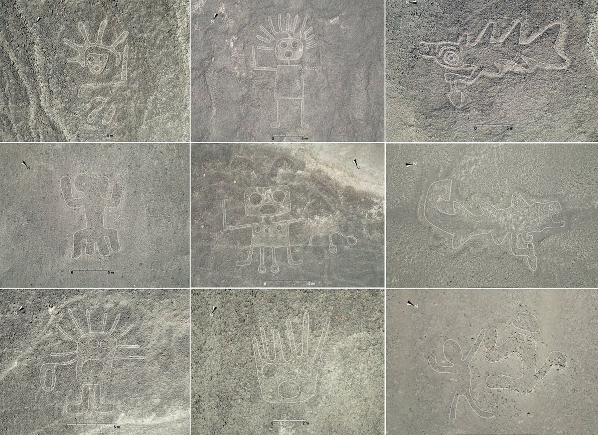
Photo: Instituto Universitario Yamagata de Nazca. Some of the new geoglyphs found in Nazca. With their lines eroded by the passage of time, AI has achieved in months what used to take decades.
Let’s have kind word for scary old artificial intelligence and how it has, for example, helped to uncover 303 new geoglyphs in the Nazca desert. (By which I don’t mean to say AI doesn’t have serious potential dangers.)
In an El País archaeological article from Peru, Miguel Ángel Criado reports, “With the help of an artificial intelligence (AI) system, a group of archaeologists has uncovered in just a few months almost as many geoglyphs in the Nazca Desert (Peru) as those found in all of the last century. The large number of new figures has allowed the researchers to differentiate between two main types, and to offer an explanation of the possible reasons or functions that led their creators to draw them on the ground more than 2,000 years ago.
“The Nazca desert, with an area of about 1,900 square miles and an average altitude of 500 meters above sea level, has very special climatic conditions. It hardly ever rains, the hot air blocks the wind and the dry land has prevented the development of agriculture or livestock. Combined, all this has allowed a series of lines and figures, formed by stacking and aligning pebbles and stones, to be preserved for centuries.
“The first layer of soil is made up of a blanket of small reddish stones that, when lifted, reveal a second yellowish layer. This difference in color is the basis of the geoglyphs and is what was used to create them by the ancient Nazca civilization. Some are straight lines stretching several miles. Others are geometric shapes or rectilinear figures, also huge in size.
“The other major category includes the so-called relief-type geoglyphs, which are smaller. In the 1930s, Peruvian aviators discovered the first ones, and by the end of the century more than a hundred had been identified, such as the hummingbird, the frog and the whale. Since 2004, supported by high-resolution satellite images, Japanese archaeologists have discovered 318 more, almost all of them high-profile geoglyphs. The same team, led by Masato Sakai, a scientist from Yamagata University (Japan), has discovered 303 new geoglyphs in a single campaign, supported by artificial intelligence. …
“ ‘The Nazca Pampa is a vast area covering more than 400 square kilometres and no exhaustive study has been carried out,’ the Japanese scientist recalls. Only the northern part, where the large linear geoglyphs are concentrated, ‘has been studied relatively intensively.’ … But scattered throughout the rest of the desert are many relief-type figures that are smaller and that the passage of time has made more difficult to detect.
“Convinced that there were many more, Sakai and his team contacted IBM’s artificial intelligence division. … They had high-resolution images obtained from airplanes or satellites of all of Nazca, but with a resolution of up to a few centimeters per pixel, the human eye would have needed years, if not decades, to analyze all the data. They left that job to the AI system. Although it was not easy to train its artificial vision … with so few previous images and so different from each other, the machine proposed 1,309 candidates. The figure came from a previous selection also made by the AI with 36 images for each candidate. With this selection, the researchers carried out a field expedition between September 2022 and February 2023. The result, as reported in the scientific journal PNAS, is 303 new geoglyphs added to this cultural heritage of humanity. All are relief-type geoglyphs.
“The newly discovered shapes bring the total number found in Nazca to 50 line-type and 683 relief-type geoglyphs, some geometric and others forming figures. The large amount has allowed the authors of this work to detect patterns and differences. Almost all of the former (the monkey, the condor, the cactus…) represent wild animals or plants. However, among the latter, almost 82% show human elements or elements modified by humans. ‘[There] are scenes of human sacrifice,’ says Sakai. …
“The accumulation of data that has made this work possible brings to light a double connection. On the one hand, these relief-type forms are found a few meters from one of the many paths that cross the desert … paths created by the passage of people until a path is created. According to the authors of the study, these creations were made to be seen by travelers.
“On the other hand, the large linear figures appear very close, also meters away, from one of the many straight lines that cut through the pampas. Here, according to Sakai, the symbolic value rules: ‘The line-type geoglyphs are drawn at the start and end points of the pilgrimage route to the Cahuachi ceremonial center. They were ceremonial spaces with shapes of animals and other figures. Meanwhile, the relief-type geoglyphs can be observed when walking along the paths.’
“Cahuachi was the seat of spiritual power of the Nazca culture between from around 100 BC to 500 AD and, for the authors, the large forms could be ceremonial stops on the pilgrimage to or from there.
“These explanations do not necessarily rule out, according to the authors, other possible functions that have been attributed to the Nazca lines and figures, such as being calendars, astronomical maps or even systems for capturing the little water that fell.”
Things do get fuzzy when we start to interpret ancient signs. Read more at El Pais, here. No firewall.
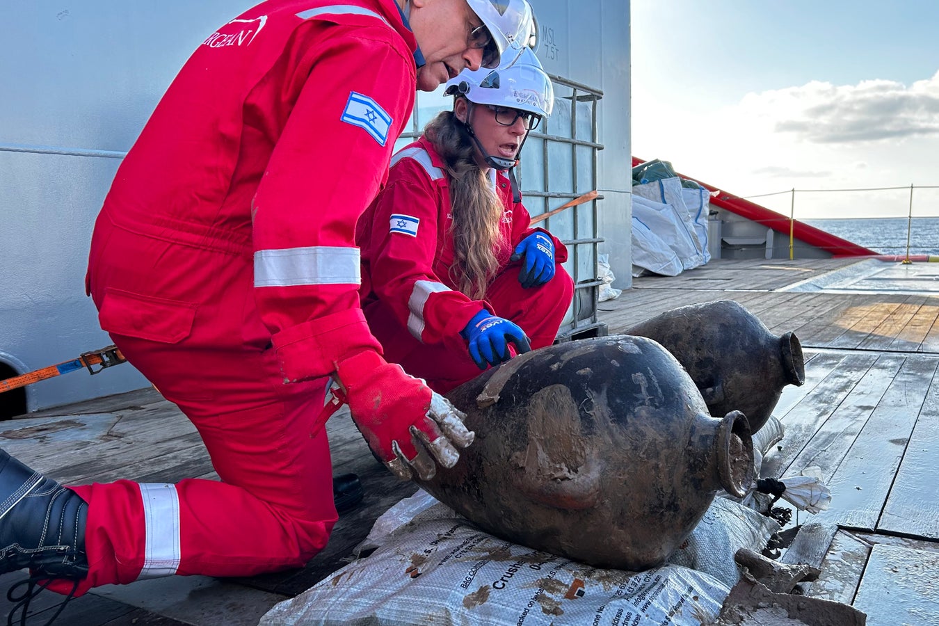
Photo: Ilan Ben Zion. IAA archaeologist Jacob Sharvit (left) and Energean environmental lead Karnit Bahartan examine Canaanite storage jars retrieved from the seafloor of the Mediterranean on May 30, 2024.They are from the Bronze Age (which ran about 3300 to 1200 BC, according to Wikipedia).
Judging from past comments here, we all like archaeology stories, especially those that explore the mysteries of shipwrecks. It must be something about realizing that nothing is ever completely lost.
At Scientific American, Ilan Ben Zion reports on the recent discovery of a Bronze Age shipwreck in the Mediterranean.
“Golden sunlight fell on the two amphorae, still caked in brown ooze, as they breached the Mediterranean’s waves. Their ascent from the seafloor, more than a mile down and 60 miles from land, had taken three hours. It was the first daylight they had seen in at least 3,200 years, and they came from the only Bronze Age shipwreck discovered in deep waters.
“Archaeologists retrieved these Canaanite storage jars, just two from a cargo of dozens located far off northern Israel’s coast in May.
” ‘It’s the only ship from this period that was found in the deep sea,’ one of the final frontiers of archaeology, says Jacob Sharvit, director of marine archaeology at the Israel Antiquities Authority. Only a handful of other Late Bronze Age ships have been discovered — all of them in shallow coastal waters of the Mediterranean Sea, including in the Aegean Sea.
“Sharvit helped spearhead a complex archaeological operation far offshore, along with the Israel Antiquities Authority (IAA) and offshore gas firm Energean to retrieve the jars from the seafloor.
“In the Bronze Age people shipped these storage jars across the Levant starting around 2000 B.C.E., when maritime trade in the Mediterranean exploded.
“ ‘They’re always either pointy or rounded at the bottom,’ so they rock with ship’s motion but don’t tip over and break, says Shelley Wachsmann, a nautical archaeology expert at Texas A&M University, who was not involved in the research.
“These workaday ceramics evolved so consistently over the centuries that they can be reliably dated with an examination of their shape and design. Based on the recently discovered jars’ neck, the pronounced angle of their shoulders and their pointed base, these amphorae are estimated to date to between 1400 and 1200 B.C.E., the IAA said in a recent press release.
“At that time, the ship and its crew sailed a world of prolific international trade, diplomacy and relative stability in the eastern Mediterranean, which was dominated by the Egyptian and Hittite empires. Merchant ships carrying olive oil, wine, ores, timber, precious stones and numerous other goods plied the seas between Greece, Cyprus, Anatolia, the Levant and Egypt.
” ‘This is the time that the Mediterranean is globalized,’ says Eric Cline, a professor of archaeology at George Washington University. ‘You’ve got lots of commerce, lots of diplomacy and lots of interconnections’ between the Egyptian, Hittite, and Assyrian empires and the lands between them, says Cline, whose newly published book, After 1177 B.C.: The Survival of Civilizations, explores the aftermath of the collapse of this Late Bronze Age international order.
In our own era of globalization, this disintegration draws particular interest among scholars looking for clues into how stable civilizations foundered in the past.
“The first signs of the shipwreck surfaced in 2023, during an environmental survey that Energean conducted ahead of its development of a new undersea natural gas field. The survey’s sonar scans were meant to locate and protect deep-sea ecological hotspots from undersea construction, says Karnit Bahartan, Energean’s environmental lead.
“Subsea surveys of the nearby Leviathan gas field conducted in 2016 by Noble Energy (now part of Chevron) reportedly turned up at least nine deep-sea archaeological sites, including a Late Bronze Age shipwreck. But details of the finds were never disclosed, and the sites were never excavated, according to a Haaretz report in 2020.
“ ‘What we were doing is looking for sensitive areas, sensitive habitats, anything that can be worth saving,’ Bahartan recalls.
“Closer examination of the sonar hits revealed that most were modern trash, Bahartan says as she flips through photographs taken by a remotely operated vehicle (ROV). The images show plastic bags, deck chairs, oil drums and a porcelain toilet, seat included. Occasionally, she says, she and her colleagues might find a solitary amphora or ceramic fragments.
“But one sonar blip turned out to be a large assemblage of jars jutting out of the seabed. ‘I didn’t know if it was something dramatic or not. I just sent it to the [Israel] Antiquities Authority,’ Bahartan says.
“Energean offered the IAA a ride onboard the Energean Star, an offshore supply and construction vessel. … Six hours out of Haifa’s port, the Energean Star hovered over the wreck’s coordinates, and a crane lowered a truck-sized, canary-yellow-and-black ROV into the sea. It took an hour to descend to the bottom. Nearing the seabed, operators released the ROV toward the site. …
“Dozens of jars, nearly identical and about half a meter long, clustered in an oblong patch roughly 46 feet long and 19 feet across. … The ROV circumnavigated the wreck, taking a high-resolution video that would be stitched into a photomosaic of the site. Sharvit picked out a couple jars from the fringes that could be extracted with minimal disturbance.
“Sharvit had hoped to find the ancient crew’s personal effects to help nail down the ship’s origin but spotted none. The IAA is running a so-called petrographic analysis of the ceramics to try to pinpoint where they came from; analyses of residue and trace elements could help identify their contents.
“Cline, who was not involved in the IAA mission or its preliminary study, says the proposed date ‘would place the wreck right in the middle of the most interconnected period of the Late Bronze Age in the Aegean and eastern Mediterranean, which is exciting.’ ”
Photo: Tony Jolliffe/ BBC. Newly uncovered frescoes in Pompeii depict Paris (of Troy) and his surprisingly peaceful kidnapping of Helen (of Greece) — the act that triggered the Trojan War.
Art from the ancient world can make you think twice about what you know. When you picture the Greek myth in which Paris steals the most beautiful woman in the world from her husband Menelaus, do you ever imagine her going quietly? I don’t. But judging from newly uncovered frescoes, people in Pompeii did. It puts a whole different cast on the Trojan Wars.
Jonathan Amos, Rebecca Morelle, and Alison Francis report at the BBC, “Stunning artworks have been uncovered in a new excavation at Pompeii, the ancient Roman city buried in an eruption from Mount Vesuvius in AD79.
“Archaeologists say the frescos are among the finest to be found in the ruins of the ancient site. Mythical Greek figures such as Helen of Troy are depicted on the high black walls of a large banqueting hall. …
“A third of the lost city has still to be cleared of volcanic debris. The current dig, the biggest in a generation, is underlining Pompeii’s position as the world’s premier window on the people and culture of the Roman empire. …
“It was likely the walls’ stark color was chosen to hide the smoke deposits from lamps used during entertaining after sunset. ‘In the shimmering light, the paintings would have almost come to life,’ [Park director Dr Gabriel Zuchtriegel] said.
“Two set-piece frescos dominate. In one, the god Apollo is seen trying to seduce the priestess Cassandra. Her rejection of him, according to legend, resulted in her prophecies being ignored. The tragic consequence is told in the second painting, in which Prince Paris meets the beautiful Helen – a union Cassandra knows will doom them all in the resulting Trojan War.
“The black room is the latest treasure to emerge from the excavation, which started 12 months ago – an investigation [featured] in a documentary series from the BBC and Lion TV … in April. …
“Staff are having to move quickly to protect new finds, removing what they can to a storeroom. For the frescos that must stay in position, a plaster glue is injected to their rear to prevent them coming away from the walls. Masonry is being shored up with scaffolding and temporary roofing is going over the top. …
“Excavations in the late 19th Century uncovered a laundry in one corner. The latest work has now revealed a wholesale bakery next door, as well as the grand residence with its black room. The team is confident the three areas can be connected, physically via the plumbing and by particular passageways, but also in terms of their ownership. The identity of this individual is hinted at in numerous inscriptions with the initials ‘ARV.’ The letters appear on walls and even on the bakery’s millstones.
” ‘We know who ARV is: he’s Aulus Rustius Verus,’ explained park archaeologist Dr Sophie Hay. ‘We know him from other political propaganda in Pompeii. He’s a politician. He’s super-rich. We think he may be the one who owns the posh house behind the bakery and the laundry.’
“What’s clear, however, is that all the properties were undergoing renovation at the time of the eruption. Escaping workers left roof tiles neatly stacked; their pots of lime mortar are still filled, waiting to be used; their trowels and pickaxes remain, although the wooden handles have long since rotted away.
“Dr Lia Trapani catalogues everything from the dig. She reaches for one of the thousand or more boxes of artifacts in her storeroom and pulls out a squat, turquoise cone. ‘It’s the lead weight from a plumb line.’ Just like today’s builders, the Roman workers would have used it to align vertical surfaces.
“She holds the cone between her fingers: ‘If you look closely you can see a little piece of Roman string is still attached.’
“Dr Alessandro Russo has been the other co-lead archaeologist on the dig. He wants to show us a ceiling fresco recovered from one room. Smashed during the eruption, its recovered pieces have been laid out, jigsaw-style, on a large table.
“He’s sprayed the chunks of plaster with a mist of water, which makes the detail and vivid colours jump out. You can see landscapes with Egyptian characters; foods and flowers; and some imposing theatrical masks.
” ‘This is my favorite discovery in this excavation because it is complex and rare. It is high-quality for a high-status individual,’ he explained.”
At the BBC, here, read that there’s a dark side to what they’re finding. No paywall.
Photo: Serhat Cetinkaya/Anadolu/Getty Images. A 8,600-year-old bread was found at the Neolithic archeological site at Cumra district in Konya, Turkey.
You never know what you’ll find once you start digging. That’s true for many kinds of knowledge — and of course, for archeological sites. Consider this site in Turkey and the world’s oldest piece of bread.
“Archaeologists in Turkey have uncovered what could be the oldest known piece of fermented bread made by humans at a site dating back to around 6,600 BC.
“The piece of bread was discovered in Turkey’s central Anatolia in the ancient stone age site of Çatalhöyük – one of the largest and best-preserved remains of an early agrarian society around 8,600 years old. Researchers suspect the early human settlement in the Turkish province of Konya flourished between 6,700 to 6,500 BC. …
“Artifacts and structures uncovered at the site over the years suggest the residents of Çatalhöyük were pioneers of early farming, known to have cultivated wheat and barley as well as herding sheep and goats.
“The Unesco World Heritage site was one of the world’s first places of urbanization, accommodating over 8,000 people in its heyday between around 10,000 BC to 2,000 BC.”
For more details, listen to an audio at Public Radio International’s The World, here.
And at PNAS, here, you can read related research on the origins of bread. Amaia Arranz-Otaegui et al describe “the earliest empirical evidence for the preparation of bread-like products by Natufian hunter-gatherers, 4,000 years before the emergence of the Neolithic agricultural way of life. The discovery of charred food remains has allowed for the reconstruction of … the early production of bread-like products. [The] results suggest the use of the wild ancestors of domesticated cereals (e.g. wild einkorn) and club-rush tubers to produce flat bread-like products.”