Photo: Archaeological Park of Pompeii. A well-preserved fresco depicting the myth of Phrixus and Helle was recently uncovered at Pompeii, a city buried in 79 CE.
Have you ever felt curious about a Greek myth? Once you start digging in, you find there’s always another story behind the story. Consider the Golden Fleece of Jason and the Argonauts‘ quest. That’s a tale stirred up anew by a discovery at Pompeii.
As Rhea Nayyar reports at Hyperallergic, “Archaeologists in Italy recently uncovered a 2,000-year-old fresco in remarkable condition on the walls of the House of Leda, a Pompeii mansion under excavation since 2018 that’s recognized for its exquisite art. Painted as if it were a framed artwork on a yellow wall, the fresco depicts the Greek mythological tale of Phrixus and Helle with vibrant pigments and crisp dimensions that have been preserved beneath volcanic ash since 79 CE, after the eruption of Mount Vesuvius.
“According to the tale, Phrixus and Helle were twin children born to the Boeotian king Athamas and a nymph named Nephele. Athamas remarried to a mortal woman named Ino who hated her step-children and devised a plan to have Phrixus sacrificed by the order of an oracle so she could secure her own son’s right to the throne. Phrixus [the boy] and Helle [the girl] escaped from Boeotia with the help of the Golden Ram that flew them across the sea, but Helle sadly fell off of its back mid-flight and drowned in the ocean. Phrixus found safety with King Aeëtes of Colchis, and later married his daughter Chalciope. The fresco depicts the frequently referenced scene of Helle drowning while reaching out for her brother’s hand as the Golden Ram prepares to soar away.
“Gabriel Zuchtriegel, the director of the Pompeii Archaeological Park [says] ‘history has repeated itself’ … Phrixus and Helle were ‘two refugees at sea.’ …
“The discovery came along during the conclusion of the Great Pompeii Project that was spearheaded by the Italian government in 2012 to further excavate, stabilize, and restore structures across the ancient city amidst research efforts, climate emergencies, and increased tourism. Earlier this month, Zuchtriegel shared in an official statement that the next phase for Pompeii was to develop it from an urban planning standpoint that engages surrounding towns and cities and promotes further educational opportunities for history and culture.”
More at Hyperallergic, here. No paywall. Subscriptions welcomed.
More on the Greek myth from Greek: “Helle, for unknown reasons, fell off the ram and drowned in the strait between Europe and Asia, which was named after her the Hellespont, meaning the sea of Helle (now Dardanelles). Phrixus survived all the way to Colchis, where King Aeëtes, the son of the sun god Helios, took him in and treated him kindly, giving Phrixus his daughter, Chalciope, in marriage. In gratitude, Phrixus sacrificed the ram to Poseidon and gave the king the Golden Fleece of the ram, which Aeëtes hung in a tree in the holy grove of Ares in his kingdom, guarded by a dragon that never slept. Phrixus and Chalciope had four sons, who later joined forces with the Argonauts.”
See what I mean about the way each myth makes you want to research another myth? I’m quite intrigued by a “dragon that never slept.” Even Smaug sleeps, for goodness’ sake!
Photo: Espen Finstad/Secrets of the Ice. Melting glaciers are revealing older and older artifacts. Archaeologists discovered the arrow above in Norway’s Jotunheimen Mountains. Made out of freshwater pearl mussel, it’s one of the best preserved findings so far.
I hesitate to say that anything about climate change has an upside, but we might as well enjoy the things that keep being revealed — at least until we reach the more important goal of controlling global warming.
At Hyperallergic, Maya Pontone reports on melting glaciers in Norway and the latest Bronze Age discoveries.
“Archaeologists trekking through the Jotunheimen Mountains in Norway’s Innlandet County,” Pontone writes, “came across a remarkable find — an intact shell arrow dating back to the Early Bronze Age. Fastened with an arrowhead made of freshwater pearl mussel, the well-preserved hunting tool dates back 3,600 years and is one of eight shell arrows that have emerged from melting ice in Norway in recent years.
“On September 13, archaeologist Espen Finstad and his research team came across the artifact while checking a site as part of a routine monitoring job they typically run at the end of the field season. While the discovery of the ancient weapon was an unprecedented surprise that day, it is just one of hundreds that the Secrets of the Ice glacial archaeology team has uncovered over the past decade due to climate change.
“ ‘The glaciers and ice patches are retreating and releasing artifacts that have been frozen in time by the ice,’ Lars Holger Pilø, co-director of the archaeology program, told Hyperallergic. …
“The archaeologists have been continuously rescuing artifacts from Innlandet’s glaciers and ice patches since the fall of 2006, when the first ‘big melt‘ hit the Jotunheimen Mountains, located northwest of Oslo. [It’s the] home of the mythological jötnar, the rock and frost giants in Norse folklore. …
“ ‘Now the artifacts are exposed and deteriorating fast, so we are in a race against time to find and rescue the artifacts,’ Pilø said.
“So far, the Secrets of the Ice research team has mapped 66 ice sites and recovered approximately 4,000 finds including hunting gear and tools, textile remnants, transportation equipment, and clothing materials. The team has also found biological specimens such as antlers, bones, and dung.
“ ‘Arrows with shell arrowheads only became known in Europe when they started melting out of the ice in Norway,’ Pilø explained about the recent discovery. …
“As global warming transforms Norway’s mountainous landscape, Finstad, Pilø and their fellow glacier archaeologists are rushing to collect the exposed artifacts, which continue to get older as the ice continues to melt.
‘Most of the ice here in Norway will be gone in this century,’ Pilø said. ‘You can say that we are melting back in time.’
“ ‘The finds are incredible, but the reason they are melting out is sad,’ Pilø said, explaining how the ice melt will lead to drastic changes in Norway’s landscape, local wildlife, agriculture, tourism, and hydro-electrical power plants dependent on glacial water.
“ ‘It will be a very different world,’ he lamented.”
Feel free to revisit my February post about amateur archaeologists in Norway — the three buddies who under cover of darkness have found hundreds of previously unknown rock-carving sites. Click here.
Photo: Michigan State University Archives via the Smithsonian. Michigan State University’s first observatory, circa 1888.
Sometimes it’s just luck that starts someone on a rewarding career — or generates a lifetime of memories. Today’s story is about the trajectory of budding archaeologists.
Daniel Wu writes at the Washington Post, “Morgan Manuszak had to travel thousands of miles from her East Lansing, Mich., campus in 2022 to get some much-needed work experience. The Michigan State University senior, who studies archaeology as part of a minor in anthropology, said she was able to do archaeological fieldwork for the first time only in Isthmia, Greece, where the university hosts a field school.
“Not every budding archaeologist at Michigan State is so fortunate, students and researchers said. Opportunities for students to complete archaeological fieldwork are competitive and often require expensive overseas travel. Many students were also unable to access such trips during the pandemic, when travel was restricted.
“But soon, a new archaeological site will be waiting for the university’s undergraduates just a short walk from their dorms.
“Students working with Michigan State’s Campus Archaeology Program this summer unearthed part of the cobblestone foundation of a 142-year-old observatory in a clearing near a student residence hall, the university announced [in August]. The site of the building — Michigan State’s first observatory for astronomy, dating back to 1881 — will become a dig site next summer for the university’s undergraduates and local residents to practice archaeological techniques right on campus.
“The unlikely discovery happened this summer when construction workers attempted to install hammock poles near a student residence hall on the north end of campus, said Stacey Camp, director of the Campus Archaeology Program. They contacted the program after hitting a hard surface while trying to drive the poles into the ground.
“Researchers consulted school records and noticed that the unassuming site — a lawn shaded by leafy trees near picnic benches and a basketball court — was near the location of a century-old facility built during a key period of change for the university. Michigan State, originally an agricultural college, was slowly branching out into other fields when a professor built the observatory in 1881. …
“The observatory housed a telescope and some of the university’s early astronomy classes and was probably demolished in the 1920s, said Ben Akey, a PhD student and campus archaeologist at Michigan State.
“Akey and a team of students, including Manuszak, conducted an initial survey at the location in June, digging a grid of small holes to try to find remnants of the observatory. They dug for weeks without luck in the area where the construction crew had been working until, on the last scheduled day of searching, a shovel finally struck a small stretch of cobblestone and mortar.
“ ‘It’s a weird common occurrence in archaeology,’ Akey said. ‘Just as you’re about to move on from a site, you end up finding something that sticks you there for another few weeks.’
“Further excavation confirmed that the rock border was the foundation of the old observatory, to the excitement of Akey, Manuszak and the rest of the team. …
“ ‘It was really, really fulfilling,’ Manuszak said. …
“The Campus Archaeology Project has conducted additional research on the site since June, including a scan using ground-penetrating radar, but the bulk of the work is being saved for the university’s undergraduates.
“Some of those students have been starved for an opportunity like this, Akey and Manuszak said. The Campus Archaeology Project has conducted digs and partial excavations at other locations on campus, but the observatory will be one of the university’s oldest excavation sites. That makes a difference in a competitive field where job opportunities hinge on hands-on experience, Akey said. …
“ ‘You can sit in a classroom and learn the steps of how you’re going to lay out your grid and how you need to take note of your stratigraphy as you’re digging down for your excavation unit,’ Manuszak said. ‘But you don’t really get a feel for it until you’re doing it.’ “
More about getting hands-on experience at the Post, here. Also at the Smithsonian, where there is no paywall.
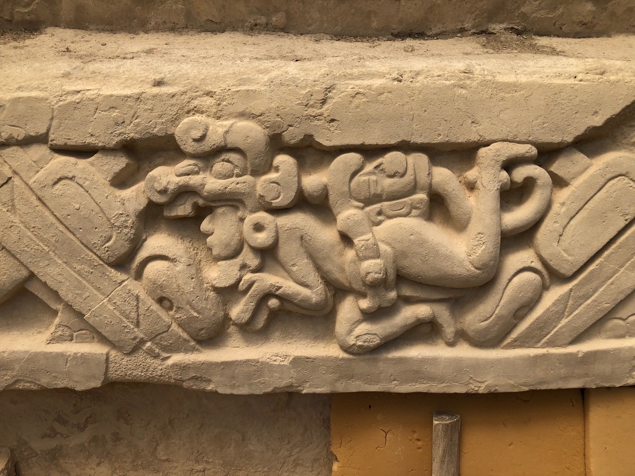
Photo: Richard Hansen. Some of the elaborate carvings researchers uncovered from the Preclassic Maya.
New tools make it possible for archaeologists to discover sites that were densely covered with vegetation. In Guatemala, as a result, almost every day leads to surprising revelations. You wouldn’t think that new insights on the Mayan culture would create controversy, but read on.
Maya Pontone reports at Hyperallergic, “Scientists have uncovered an extraordinary network of Preclassic Maya multi-tiered cities, towns, and villages that date back to 1,000 BCE in Guatemala. The findings indicate a previously unknown culturally and economically complex kingdom-state, dispelling previous beliefs of ‘sparse early human occupation in the Maya Lowlands’ and raising new anthropological questions about this ancient society, according to a research report published in the Cambridge University Press journal Ancient Mesoamerica in December.
“Using airborne light detection and ranging technology (LiDAR), the archaeologists were able to map out 964 lost settlements, which they consolidated into roughly 417 ancient towns, villages, and cities. The team also identified over 100 miles of interconnected roadway. The clusters of sites were found within the Mirador-Calakmul Karst Basin (MCKB), an area that spans northern Guatemala and southern Campeche, Mexico. Like much of the Maya Lowlands, this basin has historically been difficult for archaeologists to explore due to its dense tropical forest terrain, according to the report. New technologies such as LiDAR, however, have created more opportunities in recent years for scientists to conduct this research.
“Beginning in 2015, researchers conducted two aerial surveys using LiDAR at altitudes as high as 2,100 feet. Remote sensing technology works by bouncing pulses of light off of surfaces. The time it takes for these pulses to return to the sensor is then used to determine the distance between the receptor and the surface, allowing scientists to build a detailed map of an area’s environment.
“These analyses found ‘dense concentrations’ of sites including ceremonial and religious complexes, massive triadic constructions, at least 30 ball courts, reservoirs and terraces, defensive structures, villages, and a web of raised causeways. The labor that such constructions would have required suggest ‘a power to organize thousands of workers and specialists,’ the report reads, from lithic [stone] technicians and architects to legal enforcement and religious officials.
“One of these labor-intensive constructions identified from the LiDAR surveys includes the pyramid of Danta. Located east of the El Mirador settlement, this monumental complex stands 236 feet tall, and researchers estimate it required ‘between 6 and 10 million person-days of labor’ to erect.
“Additionally, outside of small marshes, the MCKB lacks perennial bodies of water, which forced the ancient Maya to build alternative systems for water collection and management. Researchers identified 195 artificial water reservoirs, or aguadas, as well as a series of major reservoir systems including dams and canals.
“Richard Hansen has been researching the early Maya in northern Guatemala for over 38 years. As the director of the Mirador Basin Project, he has been recognized for uncovering major ancient sites in Central America. But in recent years, critics have accused his practices of going against the wishes of local Guatemalan communities. Last month during the Los Angeles Times Festival of Books, demonstrators disrupted a talk Hansen was giving at the University of Southern California, shouting ‘This is stolen land!’ …
“Hansen has also received backlash for his work on the Mirador-Calakmul Basin Maya Security and Conservation Partnership Act, a bipartisan-backed bill introduced to the Senate in 2019. The proposed bill aimed ‘to create a sustainable tourism model’ that would give ‘low-impact, controlled access’ to the MCKB. … While Hansen argues that this bill would provide protections for the area and support local communities, critics have claimed that the act would open up the basin to large-scale tourism.
“In response, Hansen claims that all these criticisms stem from the same source — an alleged misinformation campaign orchestrated by organized crime groups in Guatemala who ‘do not want the security and conservation of that area.’ He said his research has always supported the economic and educational development of communities by hiring and training locals.”
We will have to stay tuned to see how this all shakes out.
Photo: Historic England Archive. An aerial view of the Isles of Scilly, with St Martin’s in center left and Tresco and Bryher in the background. A discovery on Bryher has led to insight into women warriors.
Today’s archaeological story is set in a British island cluster with a name that sounds like “silly.” A discovery there adds to the evidence that there have always been women who have served in male bastions.
Caroline Davies reports at the Guardian, “For decades archaeologists have puzzled over whether the stone-lined burial chamber, which was discovered in 1999 on Bryher Island, contained the remains of a man or a woman.
“Excavations revealed a sword in a copper alloy scabbard and a shield alongside the remains of the sole individual, objects commonly associated with men. But a brooch and a bronze mirror, adorned with what appears to be a sun disc motif and usually associated with women, were also found. The grave is unique in iron age western Europe for containing both mirror and sword.
“Now a scientific study led by Historic England has determined the remains are that of a woman, a discovery that could shed light on the role of female warriors during a period in which violence between communities is thought to have been a fact of life.
“Original attempts to establish sex by traditional methods, such as DNA analysis, failed because of disintegration of the bones. All that could be seen of the skeleton was a dark soil stain where the body had once lain, with only small pieces of bone and teeth. …
“Scientific advances, in particular the development of a sophisticated technique at the University of California, Davis, meant it was possible to test tooth enamel, according to research findings published in the Journal of Archaeological Science: Reports.
“Dr Glendon Parker,an adjunct associate professor in the department of environmental toxicology at UC Davis, said: ‘Tooth enamel is the hardest and most durable substance in the human body. It contains a protein with links to either the X or Y chromosome, which means it can be used to determine sex. This is useful because this protein survives well compared to DNA.
“ ‘Our analysis involved extracting traces of proteins from tiny pieces of the surviving tooth enamel. This allowed us to calculate a 96% probability that the individual was female.’
“The main form of warfare 2,000 years ago is likely to have been raids – surprise attacks – on enemy settlements. The mirror and weapons found in the grave are all associated with warfare.
“It is thought that mirrors may have be used in the iron age for signaling, communicating and coordinating attacks. They also had ritualistic functions, as a tool to communicate with the supernatural world to ensure the success of a raid or ‘cleanse’ warriors on their return.
“Dr Sarah Stark, a human skeletal biologist at Historic England, said … ‘Although we can never know completely about the symbolism of objects found in graves, the combination of a sword and a mirror suggests this woman had high status within her community and may have played a commanding role in local warfare, organizing or leading raids on rival groups. …
” ‘This could suggest that female involvement in raiding and other types of violence was more common in iron age society than we’ve previously thought, and it could have laid the foundations from which leaders like Boudicca would later emerge.’ ”
I guess all British people know who that is, but since I don’t, I went to Wikipedia.
“Boudica’s husband Prasutagus, with whom she had two daughters, ruled as a nominally independent ally of Rome. He left his kingdom jointly to his daughters and to the Roman emperor in his will. When he died, his will was ignored, and the kingdom was annexed and his property taken. … The historian Cassius Dio wrote that previous imperial donations to influential Britons were confiscated and the Roman financier and philosopher Seneca called in the loans he had forced on the reluctant Britons.
“In 60/61, Boudica led the Iceni and other British tribes in revolt. They destroyed Camulodunum (modern Colchester) … at that time a colonia for discharged Roman soldiers. Upon hearing of the revolt, the Roman governorGaius Suetonius Paulinus hurried from the island of Mona (modern Anglesey) to Londinium, the 20-year-old commercial settlement that was the rebels’ next target.
“Unable to defend the settlement, he evacuated and abandoned it. Boudica’s army defeated a detachment of the Legio IX Hispana, and burnt both Londinium and Verulamium. In all, an estimated 70,000–80,000 Romans and Britons were killed by Boudica’s followers. Suetonius, meanwhile, regrouped his forces, possibly in the West Midlands, and despite being heavily outnumbered, he decisively defeated the Britons. Boudica died, by suicide or illness, shortly afterwards. The crisis of 60/61 caused Nero to consider withdrawing all his imperial forces from Britain, but Suetonius’s victory over Boudica confirmed Roman control of the province.”
More at the Guardian, here. No firewall. Donations encouraged.
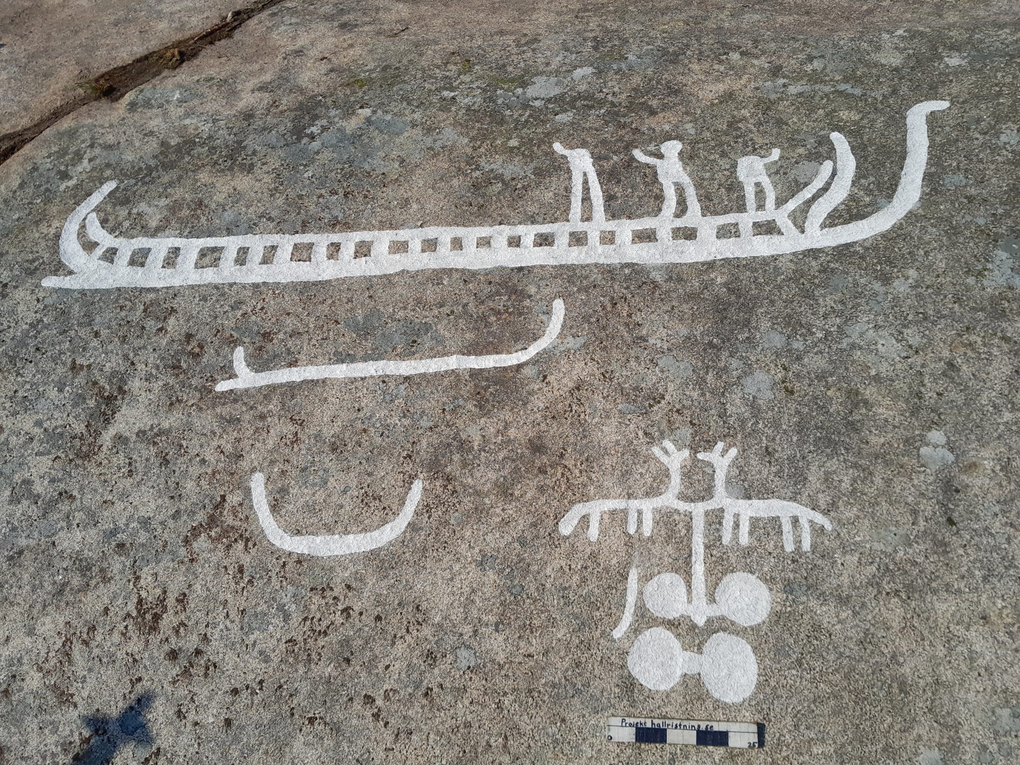
Photo: The Foundation for Documentation of Rock Carvings in Bohuslän. One of the petroglyphs recently discovered on a farm in western Sweden.
Erik is from Sweden, so he takes Suzanne and the kids there every summer for about a month, where they connect with his sister’s lively family and his mother (Stuga40 on WordPress).
My husband and I paid Stuga40 a visit back in 2017, and one of the many fun things we did with her was visit a UNESCO World Heritage Site featuring ancient petroglyphs. (See a post on that here.)
It turns out that ancient civilizations in Sweden are not done revealing their secrets. Recently, researchers found more petroglyphs, startling the farmer who lives on the land and adding to the world’s pool of knowledge.
Richard Whiddington reports at Artnet, “In early May, a group of researchers scouring the western Swedish province of Bohuslän spotted irregular markings on a moss-covered rock face. They seemed man-made and so the team carefully removed the vegetation and uncovered scores of rock carvings, around 40 in total, depicting ships, animals, and people.
“The rock carvings, or petroglyphs, date back around 2,700 years and are the latest find in Bohuslän, an area known for its rock art, most notably the Bronze Age images at Tanum, a UNESCO site. …
“The recently discovered petroglyphs were found on a steep rock face that once formed the edge of an island before sea levels gradually dropped an estimated 40 feet over the course of several hundred years. This has led researchers to speculate the artists used boats, or a form of scaffolding laid on ice, to reach the rock surface. …
“The designs were made through a laborious process of smacking stones against the granite rock that exposed an underlayer of white. This color, in addition to their size, made them highly visible from both the mainland and passing ships.
“ ‘What makes the petroglyphs completely unique is that they are located three meters above today’s ground surface,’ Foundation for Documentation of Bohuslän’s Rock Carvings wrote in a statement. ‘The motifs lie on an even line that follows the height of the sea surface from approximately 700 to 800 BCE. The motifs are also stylistically consistent with this time period.’
“The latest group of petroglyphs found includes a 13-foot-long ship, as well as carvings of people, chariots, carts, and horses. Their meaning remains unknown. Sometimes petroglyphs were used to mark out territory, though researchers believe the repeated motifs carved into rocks outside the town of Kville may suggest they were used to tell a narrative.
“Lennart Larsson, on whose farm the rock carvings were found, was pleased by the discovery. ‘I haven’t actively been looking for petroglyphs, but it’s a lot of fun,’ he told SVT, the country’s national broadcaster in interview. ‘I can sit at home on the balcony and watch the stick figures and the ships outside.’ ” More at Artnet, here.
Also, atLive Science, Martin Östholm, a project manager with the foundation, noted that he petroglyphs include depictions of ships, people and animal figures, “including four-legged creatures that may be horses. … It’s not certain why people created the carvings, he said, but they may have served to mark ownership. …
“James Dodd, a researcher at Aarhus University in Denmark and the Tanums Hällristningsmuseum’s Rock Art Research Centre Underslös in Sweden [said that] some of the motifs — including chariots, carts and animal figures — were depicted multiple times. … ‘On the basis of the repetition of the motifs, it is possible that this collection of figures forms a narrative,’ Dodd told Live Science in an email. Studies of other petroglyphs in the region have suggested that, in some cases, they may have been used in this way, but the exact meaning in this case is uncertain, he added.”
Photo: British Museum. An aerial view of the ancient city of Girsu in Tello, Iraq. The Sumerians inhabited the ancient eastern Mediterranean region of Mesopotamia.
Today we have more archaeology for people who love stories about newly discovered ancient places — particularly stories about archaeologists no one believed.
Tobi Thomas reports at the Guardian that “the archaeologist who led the discovery of a lost Sumerian temple in the ancient city of Girsu has said he was accused of ‘making it up’ and wasting funding.
“Dr Sebastien Rey led the project that discovered the 4,500-year-old palace in modern-day Iraq – thought to hold the key to more information about one of the first known civilizations.
“The Lord Palace of the Kings of the ancient Sumerian city Girsu – now located in Tello, southern Iraq – was discovered during fieldwork last year by British and Iraqi archaeologists. Alongside the ancient city, more than 200 cuneiform tablets were discovered, containing administrative records of the ancient city.
“Rey said that when he first brought up the project at international conferences no one believed him. ‘Everyone basically told me, “Oh no you’re making it up you’re wasting your time you’re wasting British Museum UK government funding.” ‘ …
“Girsu, one of the earliest known cities in the history of humankind, was built by the ancient Sumerians, who between 3,500 and 2,000 BC invented writing, built the first cities and created the first codes of law. The ancient city was first discovered 140 years ago, but the site has been the target of looting and illegal excavations. …
“Alongside the discovery of the palace and the tablets, the main temple dedicated to the Sumerian god, Ninĝirsu, was also identified. Before this pioneering fieldwork, its existence was known only from ancient inscriptions discovered alongside the first successful excavation of the ancient city.
“The project follows the Iraqi scheme first funded by the British government in response to the destruction of important heritage sites in Iraq and Syria by Islamic State. Since its establishment, more than 70 Iraqis have been trained to conduct eight seasons of fieldwork at Girsu. …
“The Sumerians inhabited the ancient eastern Mediterranean region of Mesopotamia, and were responsible for many technological advancements, including measurements of time as well as writing.
“According to Hartwig Fischer, the director of the British Museum, the site of the ancient city in southern Iraq was ‘one of the most fascinating sites I’ve ever visited. …
” ‘The collaboration between the British Museum, state board of antiquities and heritage of Iraq, and the Getty represents a vital new way of building cooperative cultural heritage projects internationally. … While our knowledge of the Sumerian world remains limited today, the work at Girsu and the discovery of the lost palace and temple hold enormous potential for our understanding of this important civilization, shedding light on the past and informing the future.’
“The ancient Sumerians may not be as well known a civilization as the ancient Egyptians or Greeks, but according to Dr Timothy Potts, the directory of the Getty Museum, Girsu is ‘probably one of the most important heritage sites in the world that very few people know about. … This innovative [Girsu Project] provides critical support for the uniquely important archaeological site of Girsu, through the training of Iraqi specialists entrusted with its development for sustainable archaeology and tourism.’
“Iraq’s culture minister, Ahmed Fakak Al-Badrani, said: ‘The British archaeological excavations in Iraq will further unveil significant ancient eras of Mesopotamia, as it is a true testimony to the strong ties between the two countries to enhance the joint cooperation.’ ” More at the Guardian, here.
The Guardian adds the “explainer” below is case your memory of the Sumerians is as fuzzy as mine.
“The Sumerians were the inhabitants of Sumer, which is the earliest known civilization in the historical region of Mesopotamia, located in modern-day southern Iraq. According to archaeological evidence, they built about a dozen city-states in the fourth millennium BC.
“Girsu, which is located in Tello, Iraq, was first discovered 140 years ago, and was significant in that it first revealed to the world the existence of the Sumerian civilization, as well as bringing to light some of the most vital monuments of Mesopotamian art and architecture.
“The Sumerians were ancient pioneers, having advanced the craft of writing, writing literature, hymns and prayers. They built the first known cities as well as creating the first known code of law. They also perfected several existing forms of technology, including the wheel, the plough and mathematics.
“The epic of Gilgamesh, considered the world’s oldest surviving piece of literature, derives from five Sumerian poems.
“They were also notably one of the first civilizations to brew beer, which was seen by the ancient people as a key to a healthy heart and liver.”
Photo: Mark Holley. Archaeologists exploring Lake Michigan’s Grand Traverse Bay uncovered a rock with a possibly prehistoric carving of a mastodon and stones arranged in a Stonehenge-like manner.
There’s always more to discover right under our feet. Or in the case of today’s report, under our boats.
In November, Archaeology World reported on some recent discoveries in Lake Michigan.
“Archaeologists found something much more fascinating than they got credit for when searching under the waters of Lake Michigan for shipwrecks: they uncovered a rock with a prehistoric carving of a mastodon, as well as a collection of stones arranged in a Stonehenge-like manner.
“In modern archaeology, the use of remote sensing techniques is common: scientists regularly survey lakes and soil for hidden objects.
“Archaeologists uncovered sunken boats and cars and even a Civil War-era pier at a depth of around 40 feet into Lake Michigan’s Grand Traverse Bay, using sonar techniques to search for shipwrecks, but among all these, they found this prehistoric surprise, which a trained eye can guess by looking at the sonar scans photos in this article.
” ‘When you see it in the water, you’re tempted to say this is absolutely real,’ said Mark Holley, a professor of underwater archaeology at Northwestern Michigan University College who made the discovery, during a news conference with photos of the boulder on display in 2007. ‘But that’s what we need the experts to come in and verify.’
“The boulder with the markings is 3.5 to 4 feet high and about 5 feet long. Photos show a surface with numerous fissures.
“Some may be natural while others appear of human origin, but those forming what could be the petroglyph stood out, Holley said.
“Viewed together, they suggest the outlines of a mastodon-like back, hump, head, trunk, tusk, triangular-shaped ear and parts of legs, he said.
“ ‘We couldn’t believe what we were looking at,’ said Greg MacMaster, president of the underwater preserve council.
“Specialists shown pictures of the boulder holding the mastodon markings have asked for more evidence before confirming the markings are an ancient petroglyph, said Holley.
“ ‘They want to actually see it,’ he said. Unfortunately, he added, ‘Experts in petroglyphs generally don’t dive, so we’re running into a little bit of a stumbling block there.’
“If found to be true, the wannabe petroglyph could be as much as 10,000 years old – coincident with the post-Ice Age presence of both humans and mastodons in the upper midwest.”
Don’t you love archaeology? I love even the “discoveries” that turn out to be untrue — like the Cardiff Giant that my family visited often in Upstate New York when I was a child. Imagine the creativity and hard work that went into pulling off a hoax like that! Of course, I prefer hoaxes that have been found out, not the ones that are still fooling people.
Photo: Evan Qu/Unsplash. Self-healing concrete at the Pantheon in Rome.
I grew up in a family that placed high value on the humanities — the arts, literature — and the people who practiced them. With the exception of our beloved Uncle Jim, who was a chemist, and Margaret Lawrence, who was a physician, we didn’t know how to admire people who didn’t fit our limited definition of “creative.”
But today, I’m bowled over by the imaginative pragmatism of people who invent solutions to real-world problems like those who reengineer gasoline engines to use electricity, for example, or who invent building materials that reduce the dangerous carbon dioxide we pump into the atmosphere.
I think even my parents would have loved that today’s scientists are finding inspiration in the ancients. After all, it was fine to admire archaeologists.
Adele Peters reports at Fast Company on research that suggests new possibilities for ancient wisdom.
“A road or bridge made from modern concrete might only last 50 years. But the massive Pantheon building in Rome, made from unreinforced concrete, has been standing for nearly two millennia. And nearby, some ancient concrete aqueducts still deliver water to the city. What made ancient Roman concrete so much more durable?
“A new study from researchers at MIT and Harvard University, along with labs in Italy and Switzerland, suggests that an ancient manufacturing technique can create self-healing concrete that naturally fills in cracks. Using a similar process now could help shrink concrete’s massive carbon footprint. ‘We’re looking to the ancient world as a source of inspiration,’ says chemist Admir Masic, an engineering professor at MIT who focuses on sustainable construction materials.
“Cement, the glue that binds concrete together, is responsible for up to 8% of global emissions when it’s made, both because of the energy it uses and the process of heating up limestone, a key ingredient in the material, which releases CO2 directly. Multiple startups are now working on alternatives: including companies that replace limestone with different rocks or add captured CO2 to the final product.
“The Roman-inspired approach is different. By making concrete last much longer, far less of it would need to be made in the first place. … The older production method also happens at a lower temperature, so it uses less energy.
“The researchers studied samples from a 2,000-year-old city wall in an Italian city. They focused on tiny white fragments of lime that aren’t found in modern concrete, but are ubiquitous in old ruins throughout the former Roman Empire. …
“In the past, some researchers thought that the fragments, called lime clasts, were the result of sloppy mixing. But it’s more likely that they were formed deliberately, and the study suggests that they are the reason the concrete lasts so long.
When tiny cracks form in the concrete, water travels to the lime clasts, which dissolve and then fill the cracks with calcium carbonate.
“The researchers attempted to duplicate the manufacturing process that created the lime clasts, and then tested the material against samples made with modern techniques. After cracking the samples and adding rainwater, they watched what happened: The old-school concrete healed itself within two weeks, while in the modern version, the cracks remained.
“Other approaches to ‘self-healing’ concrete also exist now. For example, it’s possible to embed bacteria in concrete that can fill cracks; but it’s costly to make. ‘Current self-healing concretes are very expensive because they are based on very complex chemistry, while our material is super cheap,’ Masic says. … The ancient process involves adding quicklime, a calcium oxide-based material (also known as lime), directly to other ingredients before adding water.
“A new startup is now spinning out from the research to bring the concrete to market. It may later add other features that the lab is studying, including making concrete that can absorb CO2 as it sits outside.” That would be amazing!
Speaking of “creative,” check out the varied interests of that MIT chemistry professor: “Professor Masic’s research focuses on the science-enabled engineering of sustainable construction materials for large-scale infrastructure innovation. A chemist by training, with expertise in biomineralization, he specializes in the development of multifunctional cement-based materials, ranging from self-healing concrete materials to carbon absorbing concretes and electron conducting cement-based materials.
“He is a principal investigator in the Concrete Sustainability Hub at MIT, a faculty fellow in Archaeological Materials at MIT’s Center for Materials Research in Archaeology and Ethnology (CMRAE), and the faculty director of the Refugee ACTion Hub (ReACT) at MIT. MIT ReACT aims at providing new professional content development for displaced learners around the world.”
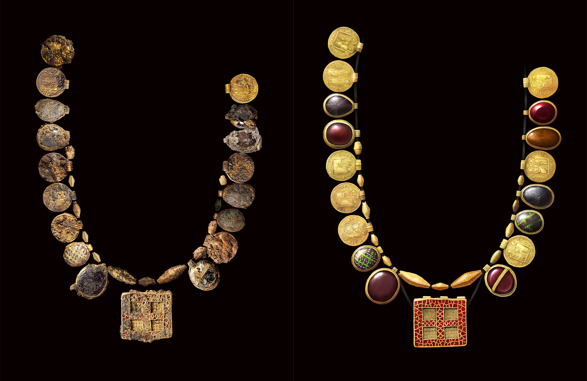
Photo: Museum of London Archaeology via Hyperallergic. A necklace found in a UK burial site probably belonged to an “elite woman“ who wanted to highlight her Christian identity, says Hyperallergic.
Archaeology reminds us that there will always be surprises to uncover no matter how much we think we know. A necklace found in a medieval burial site and considered a “once-in-a-lifetime” discovery is one recent surprise. Michael Levenson wrote about it for the New York Times.
“A 1,300-year-old gold-and-gemstone necklace that was recently discovered in an ancient grave site in England may have belonged to a woman who was an early Christian leader, according to experts involved in the discovery.
“The ancient jewelry was unearthed in Northamptonshire in April [2022] during excavations that took place ahead of a planned housing development. … The 30 pendants and beads that once formed the elaborate necklace were made from Roman coins, gold, garnets, glass and semiprecious stones. The centerpiece of the necklace, a rectangular pendant with a cross motif, was also among the artifacts that were discovered.
“ ‘When the first glints of gold started to emerge from the soil we knew this was something significant,’ Levente-Bence Balázs, a site supervisor at the Museum of London Archaeology, [said in a statement announcing the find]. …
“X-rays of soil blocks lifted from the grave also revealed an elaborately decorated cross featuring unusual depictions of human faces cast in silver, the statement said.
“While the soil is being investigated more closely, ‘this large and ornate piece suggests the woman may have been an early Christian leader,’ the statement said, adding that she might have been an abbess, royalty or both. The site also contained two decorated pots and a shallow copper dish.
“The skeleton itself has decomposed, with only tiny fragments of tooth enamel remaining. But the Museum of London Archaeology said it was almost certain that a woman was buried there because similar necklaces and lavish burial sites were almost exclusively found in female graves in the period.
Scholars said the discovery pointed to the important but often overlooked role of women in the development of early Christianity.
“ ‘The evidence does seem to point to an early female Saxon church leader, perhaps one of the first in this region,’ Helen Bond, a professor of Christian origins and head of the School of Divinity at the University of Edinburgh, in Scotland, wrote in an email. ‘We know from the gospels that women played an important role in the earliest Christian movement, acting as disciples, apostles, teachers and missionaries,’ Professor Bond wrote. ‘While their role was diminished later on at the highest levels, there were always places where women leaders continued (even sometimes as bishops).’
“Amy Brown Hughes, a historical theologian at Gordon College, who studies early Christianity, called the necklace, which has been traced to the years 630 to 670, an ‘absolutely stunning’ artifact from a volatile period when Christianity was becoming established in Anglo-Saxon England.
“Noting that women have often been left out of narratives about Christianity, Professor Hughes said the necklace provides material evidence that ‘helps to reorient our assumptions about who actually had influence and authority.’ …
“Joan E. Taylor, a professor of Christian origins and Second Temple Judaism at King’s College London, said the fact that the woman was apparently buried in a village far from a main population center ‘testifies to the troubled times in this region of Britain in the 7th century.’
“ ‘Perhaps she was on a journey, or fleeing,’ Professor Taylor wrote in an email. ‘It was a tough “Game of Thrones” world with competing royal rulers aiming for supremacy. It was also a time where Christianity was spreading, and abbesses and other high-status women could play an important role in this.’ …
“The artifacts [will] be featured in an installment of the BBC series ‘Digging for Britain.’ “
More at the Times, here. See also Hyperallergic. More photos, no firewall.
Our history with indigenous tribes is dark, and reconciliation must start with facing facts. In this endeavor, archaeology can help.
From St. Clement’s Island, Maryland, Dana Hedgpeth writes for the Washington Post on recent discoveries about a tribe’s long-ago presence.
“The small pieces of oyster shells and ceramic shards in the palm of archaeologist Julia King don’t look like much. But her team’s discoveries of roughly 1,500 pounds of shells and 200 pieces of ceramics bring new and more concrete evidence of the dominance of Native Americans who once lived at St. Clement’s Island and along the surrounding Potomac River shoreline in Southern Maryland. Native American leaders said their archaeological findings shed fresh light on their tribes’ historic presence in the state — which continues to this day but is often unknown, forgotten and ignored.
“ ‘This work is showing a reclamation of the long history of Native Americans in that area and what it means to our people,’ said Gabrielle Tayac. Tayac is a historian and member of the Piscataway Indian Nation, which considers the area its tribal homelands. ‘There’s been a willful and problematic negligence in the record about us.’
“St. Clement’s Island — an uninhabited 40-acre plot of land only accessible by boat — sits where the Potomac and Wicomico rivers meet, about half-mile off the shoreline of St. Mary’s County. There are roughly 4,500 Native Americans who are part of two state-recognized tribes — the Piscataway Conoy Tribe and the Piscataway Indian Nation — who trace their roots to the area. Piscataway means ‘the people who live where the waters meet’ in the Algonquian language.
“To many, St. Clement’s Island is best-known as the spot where roughly 150 European colonists arrived on March 25, 1634, and held the first Roman Catholic Mass in the British American colonies. …
“Few people had explored the sandy shores and grassy lands of the island until King’s research team spent several months this summer carefully digging up grass and sifting through dirt. … They found scores of Native American artifacts at the site and in collections of area residents and of a small museum on the mainland. The items included stone tools, tobacco pipes, ceramics and oyster shells, along with bits of copper, polished tubes and stone beads. All of it is evidence, said King, an archaeologist with St. Mary’s College of Maryland, of the ‘extensive exchange and network of trade’ between Piscataways and tribes from areas now known as Virginia, New York and as far away as Ohio andWest Virginia — centuries before Europeans came. …
“For Native American leaders in Southern Maryland, King’s work is a validation of their long history and continued presence in the area that’s rarely highlighted.
‘History was not written for us — or about us,’ said Francis Gray, chairman of the Piscataway Conoy Tribe. …
“Archaeological records show Native Americans were in the St. Clement’s Island area as far back as 3500 B.C., according to King. The island itself was once 400 acres, but erosion shrank it. Historians say there were an estimated 5,000 Piscataways living in the Potomac Valley area in the 1600s. …
“Rico Newman, an elder in the Choptico Band of Piscataways, said he remembers when growing up that he heard oral histories from his elders of how Piscataways followed the shad and herring runs along the nearby Wicomico River and went to St. Clement’s Island. Native Americans called it Heron Island after the bird that is fond of nesting in the area.
“ ‘There was no better place to live off the water and the land than there,’ Newman said. He recalled how his grandfather used to tell him, ‘if the heron isn’t fishing, then you weren’t fishing.’ It meant there was ‘something wrong with the fish or the water that day.’ …
“In the early 1600s, Piscataways traded with Europeans from the sister colony in Jamestown, Va. For the Piscataways, the trade meant protection for their homeland from Iroquois. English copper, beads and metal tools ‘made the newcomers useful that they need not be killed or left to starve,’ according to Piscataway leaders and historians.
“The Piscataways’ homeland changed dramatically when in March 1634, two ships — the Ark and the Dove — arrived with colonists looking to create a settlement. To celebrate their arrival, the colonists held the first Catholic Mass in the New World.
“The colonists knew of the disagreements and slayings between Native Americans and settlers at Jamestown, so they planned a different approach. The Calvert family, who founded Maryland as a colony, ‘didn’t want to pay for the costly kinds of wars experienced in Virginia,’ King said, ‘so they made the decision to forge diplomatic relationships with the Indians.’
“They went from St. Clement’s upriver to see the Piscataway tayac — the word for leader in the Algonquian language. They told Wannas, the Piscataway tayac at the time, they’d ‘come not to make war, but out of good will toward them,’ according to records at the St. Clement’s Island museum.
“Wannas, the tayac, cautiously responded to them, saying the Native Americans did not welcome the colonists, but also was not going to force them to leave. The colonists decided St. Clement’s was too small and well-established as ‘Indian country,’ so they returned and went down the river to what would become St. Mary’s City, where they bought land from the Yaocomicos and set up the first English settlement in Maryland.
“By 1650, more colonists moved to the area, and they created a reservation for the Piscataways, but eventually, King said, the Native Americans were pushed out as colonists took over. Some Piscataways went north to what’s now Frederick. Others went to Virginia. And some stayed, but they were ‘no longer considered a sovereign nation,’ King said. …
“Karen Stone, the executive director of the St. Clement’s Island museum, said a major renovation will start early next year with new exhibits that will tell Maryland’s history from the points of view of the colonists and the Piscataways. She said local Native American leaders are involved in designing the materials and exhibits for the new museum to give a more complete story and more accurate history of the Piscataways.”
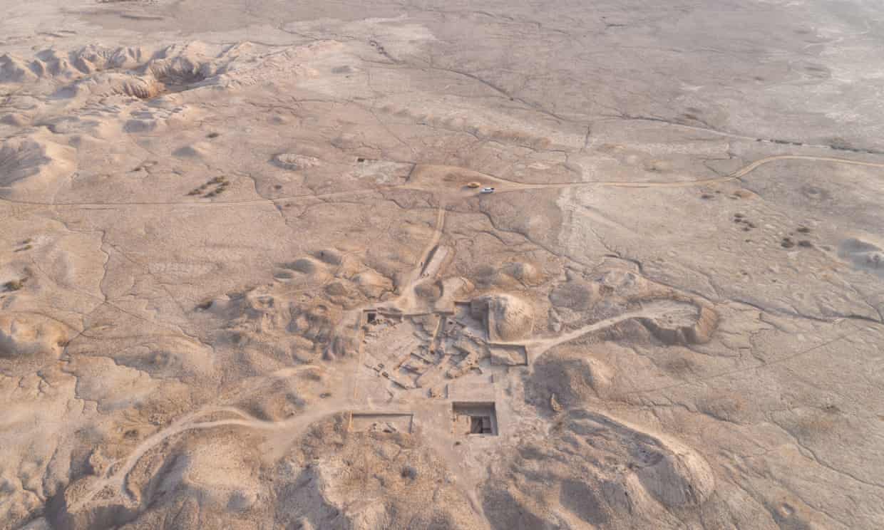
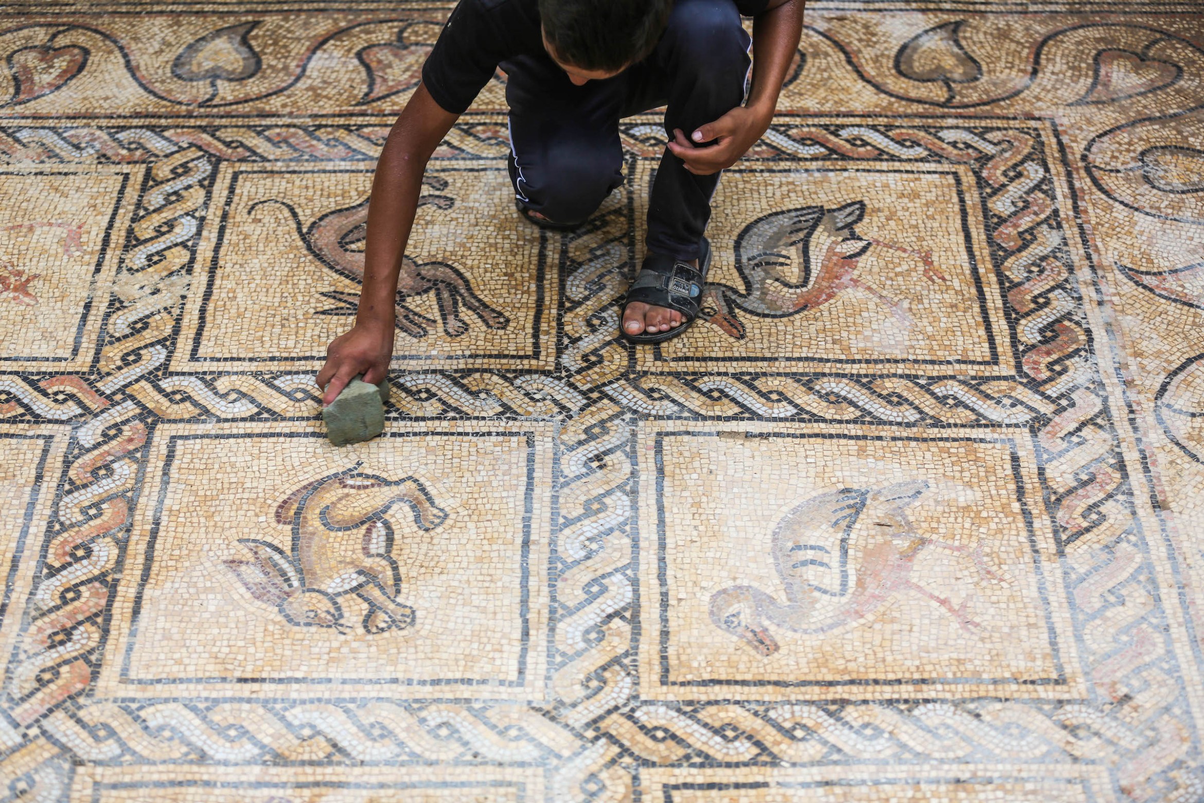
Photo: Ahmed Zakot. A Palestinian farmer unearthed a Byzantine floor mosaic beneath his olive grove.
We keep learning that beautiful discoveries can still be made, even in mundane settings. Perhaps you have discovered yellowed letters your parents wrote to each other when courting. Perhaps there was an antique bottle inside a wall when you renovated.
Such items can be exciting, but it’s hard to beat the discovery a farmer in today’s stumbled upon.
Elaine Velie reports at Hyperallergic, “Salman al-Nabahin, a farmer from Gaza’s Bureij refugee camp, was trying to plant new olive trees in his orchard but something underneath the soil was standing in his way. He investigated for three months, digging out the soil with his son until they unearthed a stunningly well-preserved Byzantine floor mosaic.
“Al-Nabahin told Reuters that he searched the internet to asses the mosaic’s origins. An archaeologist from the French Biblical and Archaeological School of Jerusalem, René Elter, later confirmed the work as a Byzantine mosaic, placing the mosaic between the fifth and seventh centuries CE. …
“ ‘Never have mosaic floors of this finesse, this precision in the graphics and richness of the colors been discovered in the Gaza Strip,’ Elter [told the Associated Press], adding that more research is needed to determine the work’s intended function.
“The Palestinian Ministry of Culture stated that investigation into the mosaic was still in its early stages and a team of national experts would partner with experts at the French Biblical and Archaeological School of Jerusalem to research the work.
“Gaza is situated on a thriving ancient trade route, and dozens of important archaeological discoveries have been uncovered there in the last few years. The recently revealed mosaic, however, sits less than a mile away from the Gaza-Israel barrier, which Elten said puts the discovery in ‘grave danger.’ …
“ ‘I see it as a treasure, dearer than a treasure,’ al-Nabahin told Reuters. ‘It isn’t personal, it belongs to every Palestinian.’ “
Sarah Kuta at the Smithsonianadds, “Now, archaeologists with the Palestinian Ministry of Tourism and Antiquities and the French Archaeology School are hard at work studying the flooring to learn more about its ‘secrets and civilization values,’ says the ministry in a press statement.
“The mosaic features 17 iconographies of birds and other animals depicted in bright colors. Archaeologists … don’t know whether the mosaic had religious or secular origins.
“The farmer has been covering the unearthed areas of the mosaic floor with tin sheets to protect them; so far, he’s dug up three separate sections, the widest measuring 6 feet by 9 feet, according to Fares Akram of the Associated Press. In total, the land covering the entire mosaic is about 5,400 square feet, and the mosaic itself measures about 250 square feet. Some parts of the mosaic appear to be damaged, likely from the roots of an old olive tree.
“ ‘These are the most beautiful mosaic floors discovered in Gaza, both in terms of the quality of the graphic representation and the complexity of the geometry,’ [Elter] tells the AP. …
“The Bureij refugee camp [is] located about half a mile from the border with Israel. Archaeologists and other experts are concerned about the mosaic’s future because of the ongoing Israeli-Palestinian conflict, as well as looting and a lack of funding for historical preservation.
“ ‘It is a spectacular find, especially as our knowledge of archaeology is sadly so spotty given circumstances there,’ Asa Eger, an archaeologist at the University of North Carolina at Greensboro, tells the Art Newspaper’s Hadani Ditmars. ‘Gaza was very important during the period of this mosaic and known for its burgeoning wine production exported across the Mediterranean.’ “
You’ll love the photos at Hyperallergic, here, and at Smithsonian, here. No firewalls.
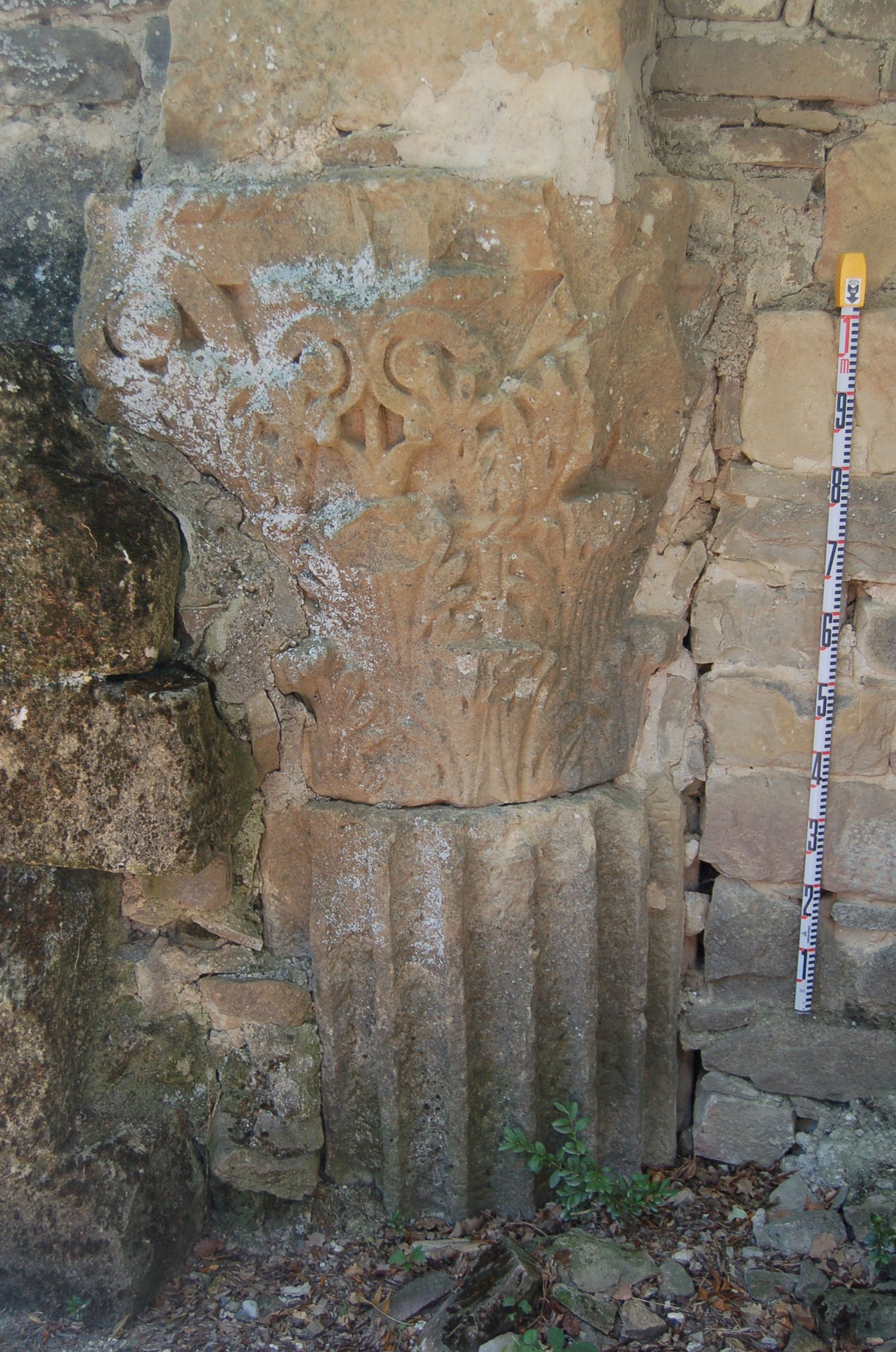
Photo: El País. A Corinthian capital and fluted drum with a shaft located in a city discovered at the foot of the Pyrenees in 2018.
Do you ever wonder what sort of report archaeologists of a future civilization would write about your town? What if they had only the location and a few crumbled buildings to go on, no contemporary testimony? That was the plight of a group of archaeologists in Spain who investigated a “new” ancient city.
Vicente G. Olaya says at El País that archaeologists were surprised that they didn’t know the name of a recently unearthed city, but there were simply no historical documents mentioning it.
“In 2018,” he says, “the City Council of Artieda — located in northeastern Spain in the province of Zaragoza, and part of the country’s Aragon region — asked the University of Zaragoza’s Archaeology Department for help in studying some ruins located around the San Pedro hermitage, known variously as El Forau de la Tuta, Campo de la Virgen, or Campo del Royo.
“Three years later, the experts have confirmed that these sites formed a large single archaeological complex, and they detected two phases of occupation on the surface of the site: one during the imperial Roman period (the 1st to 5th centuries) and another during the early-medieval Christian era (the 9th to 13th centuries). Now, the research team has published the results in a report, El Forau de la Tuta: A Hitherto Unknown Roman Imperial City on the Southern Slopes of the Pyrenees. …
“The report notes that based on important evidence from the ruins preserved in the hermitage, as well as artifacts held in various public and private collections and the findings at the site, the settlement was ‘of urban character — the city’s name is currently unknown — and it developed during the [Roman] imperial period. Later, the same site took on another iteration as a rural habitat during the Visigoth and early Andalusian periods.’
“The specialists have also found that, between the 9th and 13th centuries, another peasant habitat-type town or village was superimposed on top of the Roman settlement. They have identified the village as Artede, Arteda, Artieda or Arteda Ciuitate. The medieval enclave’s ruins include the apse area of the church, which was part of the San Pedro hermitage; numerous silos with circular openings, which were excavated from the subsoil and only perceptible by geo-radar; and an extensive cemetery consistent with Christian burial rites. …
“The El Forau de la Tuta site is located 1.5 kilometers from Artieda’s city center, on the fertile plain of the Aragón River. … It is possible that the site’s dimensions are even larger and that it extends to other — still unexplored — agricultural lands.
“The Roman settlement stood next to the road connecting three northern cities. … Currently known as Camino Real de Ruesta a Mianos (the High Road from Ruesta to Mianos), the road lasted through the Middle Ages as a stretch of the French Route, the Arles Way or the Via Tolosana (Tolouse Route), as part of the Way of St. James (Camino de Santiago). …
“Inside the hermitage, the study’s authors have identified two Corinthian capitals, three Italic Attic bases, a classical Attic base, several flat-edged fluted shaft drums, and a fragment of cornice. The huge dimensions and typology of the artifacts indicate that they came from several early [Roman Empire] public buildings. …
“The study confirms that these pieces come from at least two different monuments. Their typologies indicate that they were sculpted more than half a century apart, ‘which demonstrates a prolonged period in the process of monumentalizing the city.’
“To the west of El Forau de la Tuta, next to the San Pedro ravine, ‘an impressive set of public works made of opus caementicium (the Romans’ early version of concrete) including at least four sewer outlets, a powerful massive abutment, a foundation, and a series of quadrangular structures,’ possibly supply cisterns, is also preserved. … The presence of these works is typical of urban settlements, where water drainage was a problem that had to be addressed, especially in relation to buildings, such as bath houses, that produced a large amount of water waste. …
“Archaeologists are also currently studying a sculptural fragment that is preserved in an Artieda private collection. The artifact — which was collected near the hermitage — is an incomplete, nearly life-sized left hand that holds a patera umbilicata [an offering bowl], which would have been part of a statue representing an offering figure. …
“In the first round of excavations in 2021, the archaeologists confirmed the existence of an intersection of two roads. ‘On one of the roads, possibly one of the settlement’s main streets, we documented the ruins of a sidewalk and a surface channel for draining water, which pedestrians could circumvent by means of three steppingstones.’ …
“In one of the excavations they performed, the archaeologists found ample remains of black and white mosaics made with tesserae (small cubes of stone or glass) and fragments of rudus (a layer of material placed under the tesserae). …
“Inside this structure, under a large number of slabs that fell in the building’s collapse, archaeologists found a practically complete black-and-white tessellated pavement (with some isolated red and yellow tesserae); it was extraordinarily preserved. Decorated with iconographic motifs in white on a black background, it has shells or scallops in the four corners, while the central emblem features seahorses, ridden by little Cupids, facing each other next to three representations of marine animals, a fish in the upper part and possibly two dolphins in the lower part.
“Thus, the archaeologists are certain that everything they’ve found so far ‘corresponds to a single urban complex from between the first and second centuries, and that the city had infrastructure and public monuments, including baths, a water supply system, regular urban planning, sewers, and possibly a temple.’ ”
I can’t help thinking about the way early archaeologists (Schliemann, say, at Troy) barged in and dug at random, destroying historical records. Imagine how carefully and boringly the archaeologists in today’s story had to sift every little thing to discover the town built on top of the Roman city — and date both!
Photo:Far Western Anthropological Research Group. Archaeologists and members of the Muwekma Ohlone Tribe worked together on a project that revealed the longstanding genetic roots of some of the region’s Native peoples.
As I learn more about what our dominant culture has done to native tribes, the thing that really gets me is how recent some of the travesties have occurred — and for what stupid reasons. For example, a 1927 California official deciding they “didn’t need land.” Read on.
Jane Recker writes at the Smithsonian Magazine that “for decades, a misperception that the San Francisco Bay Area’s Muwekma Ohlone Tribe was ‘extinct’ barred its living members from receiving federal recognition.
“Soon, however, that might change. As Celina Tebor reports for USA Today, a new DNA analysis shows a genetic through line between 2,000-year-old skeletons found in California and modern-day Muwekma Ohlone people.
“ ‘The study reaffirms the Muwekma Ohlone’s deep-time ties to the area, providing evidence that disagrees with linguistic and archaeological reconstructions positing that the Ohlone are late migrants to the region,’ write the authors in the paper.
“Members of the tribe, scholars and the public are hailing the work as a chance to correct the record — and perhaps open up opportunities for the tribe to regain federal recognition. …
“The tribe’s history mirrors that of other Native Californians. After more than 10,000 years in the area, Native people were forced to submit to colonization and Christian indoctrination — first by the Spaniards, who arrived in 1776, and then, beginning in the 19th century, by settlers from the growing United States.
“As a result, the Ohlone and other Native groups lost significant numbers to disease and forced labor. Before European contact, at least 300,000 Native people who spoke 135 distinct dialects lived in what is now California, per the Library of Congress. By 1848, that number had been halved. Just 25 years later, in 1873, only 30,000 remained. Now, USA Today reports, there are just 500 members of the Muwekma Ohlone Tribe.
“The Ohlone people once lived on about 4.3 million acres in the Bay Area. But federal negligence and anthropologist A.L. Kroeber’s 1925 assessment that Native Californians were ‘extinct for all practical purposes’ caused the federal government to first strip the Muwekma Ohlone of their land, then deny them federal recognition, writes Les W. Field, a cultural anthropologist who collaborates with the Muwekma Ohlone, in the Wicazo Sa Review.
“Even though Kroeber recanted his erroneous statement in the 1950s, the lasting damage from his diagnosis meant the very much not-extinct members of the Muwekma Ohlone Tribe never regained federal recognition, according to the New York Times’ Sabrina Imbler.
“The new research could change that. It arose after the 2014 selection of a site for a San Francisco Public Utilities Commission educational facility. The area likely contained human remains, triggering a California policy that requires developers to contact the most likely descendants of people buried in Native American sites before digging or building. When officials contacted the Muwekma Ohlone Tribe, its members requested a study of two settlement areas — Síi Túupentak (Place of the Water Round House Site) and Rummey Ta Kuččuwiš Tiprectak (Place of the Stream of the Lagoon Site).
“Experts from Stanford University, the University of Illinois Urbana-Champaign, cultural resources consulting firm Far Western Anthropological Research Group and other institutions led the research. But members of the Muwekma Ohlone Tribe were involved in every aspect of the study. …
“Researchers and tribe members alike commented on the unique nature of the collaboration.
“ ‘When you’re a student doing the work, it’s not common to have this kind of direct connection to the people who are “the data” that you’re working with,’ says lead author Alissa Severson, a doctoral student at Stanford University at the time of the research, in a statement. ‘We got to have that dialogue, where we could discuss what we’re doing and what we found, and how that makes sense with their history. I felt very lucky to be working on this project.’ …
“The team analyzed the DNA of 12 individuals buried between 300 and 1,900 years ago, then compared the genomes to those of a variety of Indigenous Americans. They found ‘genetic continuity’ between all 12 individuals studied and eight modern-day Muwekma Ohlone Tribe members. …
“Tribe members hope the new evidence of the Muwekma Ohlone Tribe’s longstanding connection to the land — and their ancestors — will spur politicians to finally recognize the tribe. According to an official tribal website, Muwekma Ohlone families started the reapplication process in the early 1980s and officially petitioned the U.S. government for recognition in 1995. Despite filing a lawsuit against the Bureau of Indian Affairs, the tribe is still not recognized by the U.S. government.
“Co-author Alan Leventhal, a tribal ethnohistorian and archaeologist who works with the Muwekma Ohlone Tribe, tells USA Today he’s hopeful this new research will help cut through some of the bureaucratic red tape that’s been delaying the tribe’s petition.”
There’s more at the New York Times, where Sabrina Imbler notes, “The Muwekma can trace their ancestry through several missions in the Bay Area and resided on small settlements called rancherias until the early 1900s, Leventhal said.
“The tribe had once been federally recognized under a different name, the Verona Band of Alameda County. But it lost recognition after 1927, when a superintendent from Sacramento determined that the Muwekma and more than 100 other tribal bands did not need land, effectively terminating the tribe’s formal federal recognition, Mr. Leventhal said. ‘The tribe was never terminated by any act of Congress,’ he added. …
” ‘The cost of living is pushing us out,’ Ms. Nijmeh, the tribe’s chairwoman, said. ‘Recognition means that we will be able to have a land base and have a community village and have our people stay on our lands in their rightful place.’ “
More at the Smithsonian, here, and at the Times, here.
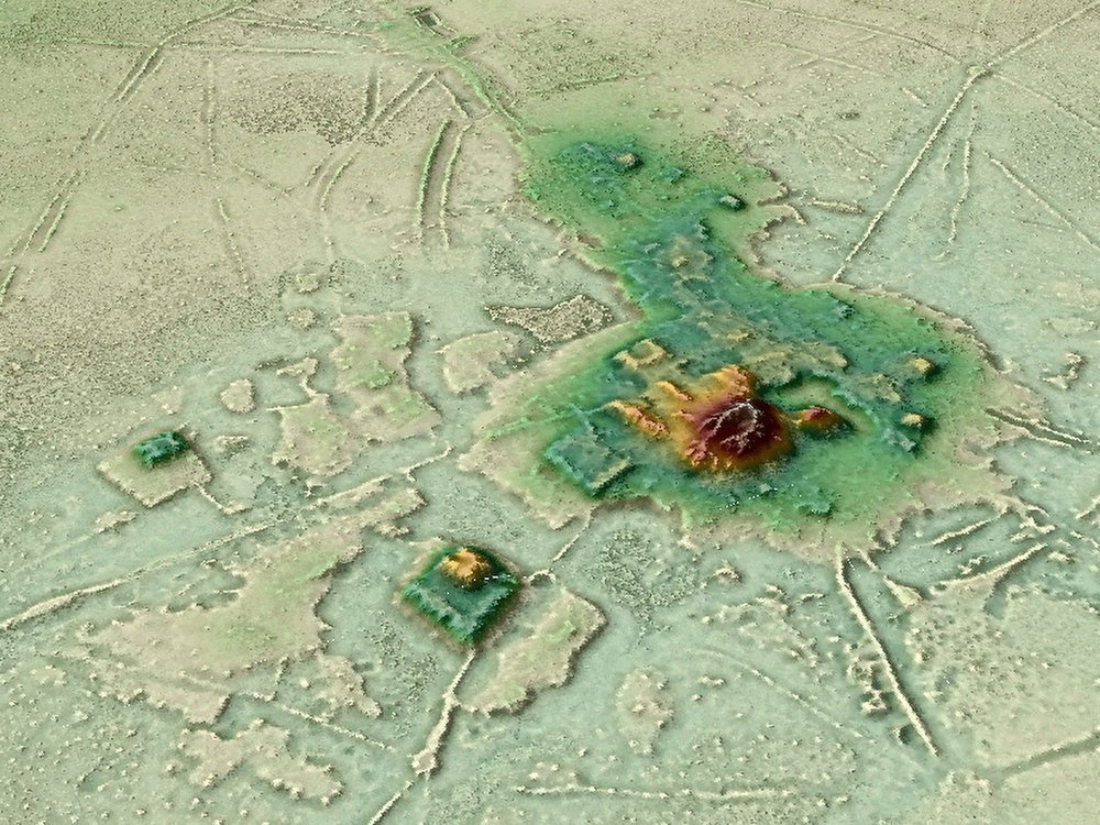
Photo: H. Prümers / DA. A 3-D animation put together using data from lidar shows the urban center of Cotoca, a lost city in the Amazon.
Today’s story is about a section of the Amazon that, thanks to new aerial studies, is starting to reveal long-hidden secrets.
Brian Handwerk reports at the Smithsonian that mapping technology has “cut through the canopy to detect sprawling urban structures in Bolivia that suggest sophisticated cultures once existed.
“The Amazon is one of the planet’s last great wildernesses, but legends have circulated for centuries that lost cities existed deep within the forests. A search for El Dorado, a supposed city of gold, lured many Spanish explorers far off the map and some of them never returned. …
“Now the plot has taken a new twist, as scientists have discovered that ancient cities really did exist in the Amazon. And while urban ruins remain extremely difficult to find in thick, remote forests, a key technology has helped change the game.
“Perched in a helicopter some 650 feet up, scientists used light-based remote sensing technology (lidar) to digitally deforest the canopy and identify the ancient ruins of a vast urban settlement around Llanos de Mojos in the Bolivian Amazon that was abandoned some 600 years ago. The new images reveal, in detail, a stronghold of the socially complex Casarabe Culture (500-1400 C.E.) with urban centers boasting monumental platform and pyramid architecture. Raised causeways connected a constellation of suburban-like settlements, which stretched for miles across a landscape that was shaped by a massive water control and distribution system with reservoirs and canals.
“The site, described [last month] in Nature, is the most striking discovery to suggest that the Amazon’s rainforest ‘wilderness’ was actually heavily populated. … Co-author Heiko Prümers, of the German Archaeological Institute, [says that] ‘a lot of people didn’t want to see that there were archaeological sites here that merit exploration.’ …
“Michael Heckenberger, an anthropologist at the University of Florida, wasn’t involved in the research but has been studying urbanism in the pre-Columbian Amazon for nearly two decades. He notes that elements of the settlement at Llanos de Mojos like moats and causeways, and a modified landscape of parklands, working forests and fish farms, have been seen elsewhere in the ancient Amazon.
“But the new research unveils something quite new. Previous examples of urbanism in the Amazon include the Upper Xingu region of the Brazilian Amazon where Heckenberger works with the Kuikuro Nation. Such settlements might be described as groups of villages networked together. They aren’t technically urban, some experts have argued, because they lack clearly defined larger centers, with monumental architecture like platform mounds and U-shaped temples.
“But those urban centers can be found at Llanos de Mojos. ‘This is in my mind the clearest case of a fully urbanized Amazonian landscape,’ Heckenberger notes. ‘It’s a marvelous piece of work.
‘It shows really remarkable range of things that humans did in the past to work with their landscapes and work with larger and larger populations.’
“Previous hands-on archaeological work and other remote-sensing efforts had revealed hundreds of isolated sites across more than 1,700 square miles of the Llano de Mojos region, including settlements inhabited year-round by the Casarabe, who hunted, fished and farmed staple crops like maize. Some 600 miles of causeways and canals had also been identified. But the logistical challenges of mapping them in a remote tropical forest hampered efforts to connect the dots and see if, or how, they were related to one another. …
“From an aircraft, a lidar system fires down a grid of infrared beams, hundreds of thousands per second, and when each beam strikes something on the Earth’s surface it bounces back with a measure of distance. This produces an enormous cloud of data points, which can be fed into computer software that creates high resolution images in which scientists can digitally deforest the Amazon. By scrubbing away trees the maps reveal the Earth’s surface and the archaeological features on it. In this case, the images clearly showed 26 unique sites, including 11 that were previously unknown. …
“Difficult as they can be to locate in the forest, earthworks clearly built by humans, designs known as geoglyphs, have been found in several other Amazon locales. In 2018, scientists using satellite images reported that large areas of Amazon forest in Brazil’s Mato Grosso state, once thought to have been sparsely inhabited at best, were dotted with villages and oddly-shaped earthwork geoglyphs. Even here, away from large rivers, many hundreds of villages could have housed up to a million people between 1250 and 1500 C.E. in an area that represents only about 7 percent of the Amazon basin. However if larger urban centers anchored these populated sites, they haven’t yet been identified. …
“The aerial view with trees stripped away revealed two centers, each anchored by a large network of regional settlements connected by numerous causeways. Those passageways radiate out from the centers like spokes on a wheel, and stretch for several miles. These connect sub-urban settlements, ranging from small settlements closer to the centers to more distant and even smaller sites that may have been used as temporary campsites. Similarly, canals also stretch from the main centers and connect to rivers and Laguna San José, which apparently delivered water to Cotoca.
“ ‘Basically they remolded the landscape in terms of their cosmology, which is mind blowing,’ says Chris Fisher, a Colorado State University Archaeologist not involved in the study who specializes in Mesoamerica. ‘The only problem is that this architecture was made from mud brick. So while at the time it was as fantastic looking as anything in the Maya region, the Maya monuments have endured because they had limestone while these just weren’t as durable.’ …
“Such discoveries of settlements were the result of very hard work. Despite the large and sophisticated populations that once thrived here, lasting evidence of urbanism has proven difficult to find in the remote and thickly forested Amazon. But lidar technology seems set to rapidly boost the pace of future discoveries.
“ ‘Lidar has been transformative for archaeology and this work is a great example of that,’ says Chris Fisher. ‘These researchers were able to see patterning that’s just not visible from the ground, and that pattern clearly showed two very large settlements, embedded within a settlement system, with a level of social complexity that really hasn’t been demonstrated very well in the Amazon,’ he says. ‘It’s absolutely amazing.’
“While it appears that the Amazon once teemed with human activity, many ancient sites have remained almost undisturbed for some 500 years, something Prümers cites as a big advantage. ‘The region has very low population density, and that means that we are finding the relics of pre-Spanish cultures over there almost untouched,’ he says.
“But the Amazon is changing rapidly. Forests are being eliminated to promote farming, ranching, energy production and the roads and dams that support such efforts. Many of those undisturbed areas, with their hidden records of past cultures, won’t remain so for long. Fisher advocates for large scale lidar scanning of the Amazon, and far beyond, through an Earth Archive project aimed at capturing what remains of the past before it’s lost to the future.
“ ‘We’re running out of time because we’re losing the Amazon,’ he says. ‘And we’re going to lose things that we never knew were there. To me that’s a real tragedy.’ ”